Roing
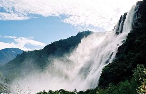
In the Indian state of Arunachal Pradesh, Roing is the sole town in the district of Lower Dibang Valley. It is the district headquarters. The dwellers of Roing hail from the tribes namely Adi-Padam and Idu-Mishmi. Three locations of the district of Lower Dibang Valley, namely Roing, Koronu and Dambuk are located in plains. Many a number of beautiful locations are present in Roing, for tourists to visit. One can enjoy the amazing variety of animals and plants, the different in the terrain, mountains with summits covered in snow, deep gorges, and rivers meandering between the hills, numerous waterfalls, lakes, historical sites and the calm, serene environment.
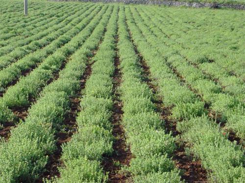
The local people cultivate agricultural crops like paddy, mustard, millet and maize. Due to the initiative of the local administration, horticulture in the region has developed and thus, at present fruits like pineapple, oranges, pears, papaya, bananas and gingers are grown.
TOURIST PLACES IN ROING
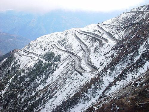
Mayudia A Unique Hill Resort: The distance between Roing and Mayudia is 56 Kms. Roing is a district headquarters. The elevation of the place is 2655 meters. Mighty hills covered with plush forests of gorgeous green trees and amazingly gorgeous terrains, encircle this place. During the months between December and March, snowfall is witnessed by this region. The wilderness of the nature can also be felt with the presence of bears, speedy wild goats, flying squirrels, huge array of birds and Mishmi Takin. In the cold climate and the gorgeous peaks, trekking could be an adventure.
Mehao Lake: The Mehao Lake is located at a distance of 14 Kms from Roing. The elevation of this place is 3000 feet above the sea level. It is a natural water body. It is believed to be one of the most breathtaking beautiful locations in the entire Arunachal Pradesh. Many a number of wild ducks come here in the lake because of the presence of the clear water. The area of the lake is 4 square kilometers. The area surrounding the lake has a wide variety of animals and plants. The sparkling clear water of the ponds gives the opportunity for an excellent boat ride. The forests also provide a nice trail for trekking activities.
The status of an Oliogotropic Lake has been given to this lake by the geologists. Oliogotropic means low in nutrients value. Hence, there is no availability of fish in the lake.
Mehao Wildlife Sanctuary: Close to Roing, this wildlife sanctuary is situated. The area of the place is 281.5 square kilometers. The elevation of the place ranges from 400 meters to 3568 meters from the mean sea level. This place has been named after the name of Mehao Lake. This place is known as a paradise of green on Earth. The terrain of the place is breathtakingly beautiful surrounded by the rough and mighty mountains and the amazing landscape. For Ornithologists, Zoologists, Botanists and Ecologists, this place is a paradise.
Sally-a lake resort: The Sally Lake is situated at a distance of 3 Kms from Roing. The lake is a natural lake. Dense forests covered with lush green trees and a serene, calm environment surrounds this lake. From the lake, an amazing picture of the valley, which is located down, can be seen. Along with the image of the valley, the view of the river Dibang meandering between mountains and spreading in different direction can be seen. The Sally Lake Tourist Lodge provides a calm and welcoming environment.
Nehru Van Udyan (Forest Park): The Nehru Van Udyan Forest Park is located on the river beds of Deopani River. It is set at a distance of a mere 1 Km from the Roing Township. Eje-Breeze Tower, a grandiose guest house offers an excellent stay here, with the guest fully enjoying the breathtaking view of the Deopani River. A well manicured garden, a nice orchid house and cactus house are present in the park. The point where the two rivers namely Eje and Eme converges, is located at a distance of few hundred meters from here.
Iphipani: The Iphi-pani ghat is located at a distance of 10 Kms from the Township of Roing. An amazing scene of the river Dibang, which is situated in the plain valley, can be obtained. Fun activities like fishing and angling can be done here.
Nijomaghat- a picnic spot: The famous Nizamghat is located at a distance of 15 kilometers from the Township of Roing. The British Government has established this place in the 19th century. The name of the place has been derived from the name of a British Political Officer namely J.F.Needham. This place is an ideal location for having an enjoyable picnic against the backdrop of the river meandering between the mighty mountains surrounded with plush green blanket of trees and vegetation. Dambuk is linked to Roing by a small ferry.
Hunli: The town of Hunli is set amidst a beautiful valley. The elevation of this place is 5000 feet above the sea level. The town is a sub-divisional head-quarter. The journey from Roing to Hunli is a breathtaking experience; one passes the Mayudia Pass, which is set at an elevation of 8800 feet, and the spectacular terrain. One can also visit a cave temple at Kunpunli, situated close to Hunli. In order to reach the cave temple, one has to for trekking of two hours. One of the catchy features of the place is the well equipped Community Information Center along with internet facilities.
Bhismaknagar: At a distance of 30 Kms from Roing, the fort of Bhismaknagar is located. The fort belongs to the 8th century, as believed. In the entire region, this location is believed to be the most ancient site of archaeological discovery. In the year 1848, initially the I. Block explored this area. Later on, in the year 1965 to 1970, it was again under excavation.
Rukmini Nati: Right in the middle of the village of Chimiri, the relics of Princess Rukmini named Rukminati is situated. It is situated at a distance of 12 Kms from Roing. The relic which is a fort dates all the way back to 14th or 15th century. The proof of the development of the then existing civilization can be obtained from the left over of the burnt and baked bricks.
Ita and Padum Pukhuri: At a distance of 14 Kms from Roing, this famous pond is situated in the village of Idlii. It is a pond built with bricks. The Padum Pakhuri is located at a distance of few hundred yards away from Itapukhuri. Hundreds and hundreds of lotus flowers bloom in this pond, during the months of October and November.
Kampona Pond: The distance between Kampona Pond and Roing is a mere 17 Kms. The pond is located in the village of Idlii. The word Kampona stands for good looking in Adi dialect. The dwelling place of Nag Raja is Kampona, according to the Adi myth.
HOW TO REACH ROING
By air: Chabua has the closest airport to Roing. It is located at a distance of 138 kms form Roing. Other airports are there in Mohanbari and Guwahati.
By rail: Tinsukia is the closest railway station. The distance between the railway station and Roing is 113 Kms.