Anjaw
The beautiful district of Anjaw came into existence in the year 2004, in the month of February. The district is surrounded by the country, China on the northern side. The elevation of the place is 1296 meters above the sea level. The district is situated on the banks of the river Lohit.
TOURIST PLACES IN ANJAW
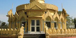
Hawai: The left hand side bank of the river Lohit contains the place called Hawai. It is the recent district headquarters. It is situated at a distance of 58 Kms from Hayuliang in its south east direction. The word “Hawai” stands for “Pond” in the Mishmi dialect. The elevation of the picturesque town is 1296 meters above the mean sea level. The cable suspension bridge, which is constructed over the river Lohit, connects it. One should definitely make a trip to this place in order to experience the lovely cool weather, the amazing sceneries surrounding it and the ethnic customs and traditions. Numerous fruits like Kiwi, Pineapple, Orange and other agricultural crops like Large Cardamom, Maize and Bazra are produced in large amount.
Hayuliang: The distance of Hayuliang and Tezu is 110 Kms. The headquarters of the district of Lohit is located in Hayuliang. It is also an Independent ADC Headquarter under the control of the Deputy Commissioner Anjaw. The word “Hayuliang” stands for “the place of my liquor” in the Mishmi dialect. The elevation of the place is 750 meters above the mean sea level. The weather of Hayuliang remains cool, enjoyable and quite healthy. The tourists enjoy the spectacular view of the location where the two rivers namely, Dalai and Lohit Rivers converge.
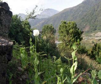
Chaglogam: The left hand bed of the River Dalai houses the place called Chaglogam. It is set amidst a breathtaking terrain. The respective distances between Chaglogam and Tezu, Hawai are 170 Kms and 107 Kms. The elevation of the place is 1258 meters above the mean sea level. Many adventurous activities can be carried out here like trekking, angling, rafting, mountain climbing and other such activities.
Walong: The meaning of the word “Walong” means “a place with full of bamboos” in the Mishmi dialect. The distance between this place and Tezu is 200 Kms. The elevation of Walong is 1094 meters above the sea level.
This place is historically significant for the fact that it witnessed the battle of 1962 between India soldiers and the Chinese soldiers, who were invading India. The presence of the picturesque terrain makes Walong a very popular sight for tourist parties. The weather remains cool and healthy. Another major location for the visitors is the hot spring which is located at a distance of 4 Kms from Walong and is situated adjacent to the river Lohit. During one’s journey to Kibithoo, one can see the Namti Valley, popularly known as the Namti Maidan. It is set at a distance of 7 Kms from Walong. This valley was the site for the 1962 battle. Dedicated to the bravery of the Indian Soldiers shown in the battle of 1962, a memorial has been constructed at Walong.
Hot Spring: There are two hotsprings located in and around this place; one is situated close to Walong and the second one is situated at the convergence of Lohit River and Dichu River, which is set at a distance of 39 Kms from Walong. The distance between this place and the Kibithoo is 64 Kms. It is located in the east of Kibithoo. One can enjoy the great view enveloping the area which consists of panoramic plateaus and meadows and spectacular hills with their summits covered in snow.
Dong: The tiny hamlet of Dong is situated on the left hand side river bed of the Lohit River. The residents are member of the Meyor Communities. The high and mighty mountains whose summits remain covered with snow and the breathtaking dense forests of pine surrounds this village. The distance of Dong from Walong is 7 Kms. A suspension bridge built over the Lohit River links this place.
Kibithoo: Near to the border of India and China, Kibithoo is situated. It a tiny town encircled with spectacular scenery. It is the Circle Headquarter. The place is located at an elevation of 1305 Meters above the sea level. The distance of Kibithoo from the north direction of Hayuliang, is 140 Kilometers. It is situated in the right hand side river bed of the gorgeous Lohit River. One can experience the grandiose beauty of the place with thick dense forests with rustling leaves, wild rash berries, vibrant colored flowers and sparkling waterfalls present in the encircling hills. The weather of the place remains cool and healthy.
HOW TO REAH ANJAW
By Flight: The closest airport to Anjaw is Guwahati.
By Road: Tinsukia has the closest bus stand to the town of Anjaw
By Rail: The Tinsukia Railway Station is the closest railway station to the town of Anjaw. Many a number of trains are present from this railway station.