Champhai
Situated close to the boundary between India and Myanmar, Champhai is a business town. The height of the place is 1678 meters. The distance between Champhai and Aizawl is 194 Kms. A spectacular and breathtaking view of the surrounding plain region and also of the neighboring hills and mountains of the country named Myanmar. These plain lands considered to be the biggest plain region of the Indian state of Mizoram. Thick plush blankets of rhododendrons cover the slopes of the hills. One can observe the ancient customs and traditions of the Mizo people in the adjacent villages.
If one wants to shop for imported items then Champhai is the place to be. This town also serves as a base point for hiking activities and also for making a trip to the neighboring attractions such as the Rih Dil, the legendary lakes, which is the situated at a distance of 5 Kms from the Myanmar border.
One of the major crowd pulling locations is the Thasiama Seno Neihna. It is basically a plateau. There are mythological tales related to this location. Another thing to see here is the river named Fiara Tui. The beginning point of the river is located in the mountain named Tan Tlang. The distance between this place and Champhai is 65 Kms. A mythical story is linked with this river. The story is that, there was a scarcity of drinking water for the inhabitants of this region. For this reason, the inhabitants had to walk for a very long expanse to obtain water. It was Fiara who stumbled upon this good supply of water. He along with his mother took a decision to hide this; however, with time, the inhabitants of the village found about it.
TOURIST PLACES IN CHAMPHAI
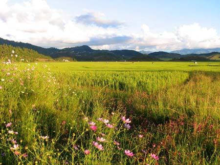
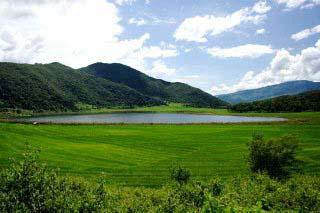
Champhai Valley: At the bottom of the Champhai town, the Champhai Valley is located. It is located near to the border between India and Myanmar. One can observe the huge assortment of plants and animals in this region. The major crop of the region is rice. A breathtaking glimpse of this valley from the Champhai town presents before our eyes, an awesome site of rice fields encircled by the Myanmar’s misty hills.
Lengteng Wildlife Sanctuary: In Mizoram’s Champhai District, the wildlife sanctuary named the Lengteng Wildlife Sanctuary is situated. One can observe here, the familiar types of animals such as the tiger, leopard, sambar, deer, barking deer, goral, serow, bar tailed pheasant, kaleej pheasant, hoolock gibbon, rhesus macaque and wild boars.
Lenteng Hills: The Lenteng Hills are located in the eastern portion of the Indian state of Mizoram. This area is especially renowned for the untouched rainforests and the intense wildlife. The height range of the hills situated here is between 400 meters to 2300 meters. A wide variety of flora and fauna are present in here. This location is perfect for carrying out hiking activities.
Murlen National Park: In Mizoram’s Champhai District, this national park named the Murlen National Park is situated. It is located at a distance of 245 Kms from the east direction of Aizawl. It is situated near to the border between India and Myanmar. This national park has area coverage of 100 square kilometers. The region consists of sub-tropical rainforests. One can observe here, the familiar types of animals such as the tiger, leopard, sambar deer, barking deer, goral, serow, bar tailed pheasant, kaleej pheasant, hoolock gibbon, rhesus macaque and wild boars.
Palak Wildlife Sanctuary: The Champhai District’s Lakher area contains the Palak Wildlife Sanctuary. It is located on the southern portion of the Indian state of Mizoram. The distance between this sanctuary and the town of Siaha is 130 Kms. 15.50 square kilometers is the amount of land covered by this sanctuary. The region mainly consists of tropical evergreen and moist deciduous forests. One can observe here, the familiar types of animals such as elephant, sambar, barking deer, leopard, rhesus macaque and different species of birds.
Rihdil: This spectacular lake is located in the country of Myanmar and is lies close to the boundary between the two countries namely India and Myanmar. The meaning of the word ‘rih’ is heart and the meaning of the word ‘dil’ is lake. The lake takes the form of a heart.
HOW TO REACH CHAMPHAI
By air: Lengpui airport is the closest air terminal to Champhai.
By rail: Bhairabi is the solitary railway station in the Indian state of Mizoram.
By road: One can reach Champhai by means of buses, taxis, jeeps and private cars.