| Home | City Bus | Maps | Villages | Cities | Rail | Tourist Places | School | College | Pin Codes | Corona Cases Count |
| Distance Calculator Bus Services IFSC Codes Trace Mobile Number Weather Search Place Trace IP Available Cash ATM/Banks Locate Polling Booth Report an Error contact People |
Head Quarters : Aizawl
Language : Mizo
Area: 3577 sq. km
Population : 404054
Sex Ratio : 1009
Density : 113/ sq. km
Literacy : 98.5
Elevation / Altitude: 48 - meters. Above Seal level
Current Time 10:30 AM
Date: Monday , Jan 05,2026 (IST)
Time zone: IST (UTC+5:30)
District Pin code Index: 796XXX
Vehicle Registration Number: MZ-01
RTO Office: Aizawl
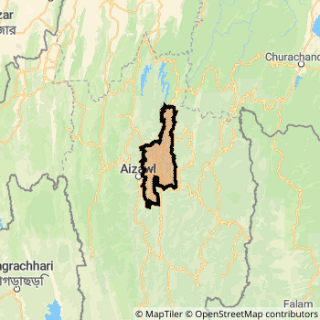
Aizawl District Map
Current Corona Virus Infected Patients Count in Aizawl District
| City Name | District Name | Total Covid cases |
|---|
Aizawl Live Weather
Temperature: 20.2 °C
clear sky
Humidity: 35%
Wind : 0.89 mt/sec towards NW
StationName : "Aizawl"
observed on Now
Temperature: 20.2 °C
clear sky
Humidity: 35%
Wind : 0.89 mt/sec towards NW
StationName : "Aizawl"
observed on Now
Aizawl Weather Forecast for Next 5 days
06-01-2026
6.9°C to 22.2°C
clear sky
6.9°C to 22.2°C
clear sky
07-01-2026
6.3°C to 23.0°C
clear sky
6.3°C to 23.0°C
clear sky
08-01-2026
6.7°C to 23.0°C
clear sky
6.7°C to 23.0°C
clear sky
09-01-2026
7.0°C to 24.1°C
few clouds, scattered clouds, broken clouds
7.0°C to 24.1°C
few clouds, scattered clouds, broken clouds
10-01-2026
7.8°C to 24.4°C
broken clouds, clear sky, scattered clouds
7.8°C to 24.4°C
broken clouds, clear sky, scattered clouds
Temples in Aizawl
Historical Daily Min/Max Temperatures (Next 7 Days)
| Years | 04 Jan | 05 Jan | 06 Jan | 07 Jan | 08 Jan | 09 Jan | 10 Jan |
|---|---|---|---|---|---|---|---|
| 2025 | 21.0°C/ 8.0°C | ||||||
| 2024 | 20.0°C/ 7.0°C | ||||||
| 2023 | 24.0°C/ 10.0°C |
About Aizawl District
Aizawl District is one among 8 Districts of Mizoram State ,India. Aizawl District Administrative head quarter is Aizawl. Aizawl District population is 404054. It is Biggest district in Mizoram State by population.Geography and Climate Aizawl District
It is Located at Latitude-23.7, Longitude-92.7. Aizawl District is sharing border with Champhai District to the East , Kolasib District to the North , Mamit District to the west , Serchhip District to the South . Aizawl District occupies an area of approximately 3577 square kilometres. . Its in the 48 meters to meters elevation range.This District belongs to Eastern India .DemoGraphics of Aizawl District
Mizo is the Local Language here. Aizawl District is divided into 6 Blocks , 94 Panchayats , 106 Villages. Thingsulthliah Block is the Smallest Block by population with 116 population. Aibawk Block is the Biggest Block by population with 1318 population.Census 2011 of Aizawl District
Aizawl district Total population is 404054 according to census 2011.Males are 201122 and Females are 202932 .Literate people are 267322 among total.Its total area is 3577 sq.km. It is the 1 st largest district in the state by Population . But 2 nd Largest District in the state By Area. 549 th Largest District in the Country By Population. 2 nd highest District in the State By literacy rate. 2 nd highest District in the Country By literacy rate.its literacy Rate is 98.5Politics in Aizawl District
Mizo National Front , INC are the major political parties in Aizawl District.Assembly constituencies in Aizawl District
Total 8 Assembly constituencies in Aizawl District.| Constituency name | MLA name | Party |
|---|---|---|
| Aizawl North-I | Vanlalhlana | |
| Aizawl North-II | Dr. Vanlalthlana | |
| Aizawl East-I | Lalthansanga | |
| Aizawl East-II | B. Lalchhanzova | |
| Aizawl South-III | Baryl Vanneihsangi | |
| Tuivawl | Lalchhandama Ralte |
Parliament constituencies in Aizawl District
Total 1 Parliament constituencies in Aizawl District.| Constituency name | MP name | Party |
|---|---|---|
| Mizoram | C LALROSANGA | Mizo National Front |
Aizawl District Political Map
Aizawl Commerce
Total Registered Comapnies with Ministry of Corporate Affairs (MCA) in Aizawl are 94Company Name : MIZORAM FOOD AND ALLIED INDUSTRIES CORPORATION LTD
Type Of Business : Manufacturing (Food stuffs)
Capital : 19.7831 Crores
Company Name : ZORAM INDUSTRIAL DEVELOPMENT CORPORATION LTD
Type Of Business : Community, personal & Social Services
Capital : 15.781 Crores
Company Name : NORTH EAST REGION HOUSING FINANCE COMPANY LIMITED
Type Of Business : Finance
Capital : 13.6665 Crores
Company Name : ZORAM MEGA FOOD PARK PRIVATE LIMITED
Type Of Business : Manufacturing (Food stuffs)
Capital : 12.0932 Crores
More Aizawl Registered Companies
Aizawl District Tourism
Aizawl , are the Tourist destinations to Visit.
Aizawl Transport
Road Transport
District Headquarters Aizawl is well connected by road . Aizawl is about 2 KM by road to Aizawl( Capital of Mizoram )Rail Transport
Bus Transport
Mizoram State Road Transportation ( MST) runs Busses from Major cities to Towns and Villages in this District.
Pin Codes in Aizawl District
796012
( Ramhlun ) ,
796014
( Bawngkawn ) ,
796025
( Durtlang ) ,
796009
( Vaivakawn ) ,
796471
( Zawlnuam ) ,
796005
( Kulikawn ) ,
796036
( Sihphir ) ,
796230
( Sialsuk ) ,
796017
( Zemabawk ) ,
796190
( Aibawk ) ,
796007
( Chandmary ) ,
796161
( Thingsulthliah ) ,
796261
( Saitual ) ,
796111
( Darlawn ) ,
796015
( Tlangnuam ) ,
796001
( Aizawl ) ,
more PinCodes
Hotels in Aizawl
Ahimsa Hotel
Hazar Khot , Zarkawt Aizawl - 796007, India
Aizawl
Contact No: 0389 - 2341133
Price Range : Rs. 800 - Rs. 800
Chawlhna Hotel
Zarkawt Aizawl - 796007, India
Aizawl
Contact No: 0389 - 2342292
Price Range : Rs. 600 - Rs. 600
Imperial Hotel
Zarkawt Aizawl - 796007, India
Aizawl
Contact No: 0389 - 2348168
Price Range : Rs. 200 - Rs. 400
Ritz, Hotel
Bara Bazar Aizawl - 796001, India
Aizawl
Contact No: 0389 - 2323358
Price Range : Rs. 800 - Rs. 1800
Near Cities
Aizawl 1 KM near
Champhai 78 KM near
Dharmanagar 99 KM near
Lunglei 104 KM near
Near By Air Ports
Aizawl Airport 14 KM near
Kumbhirgram Airport 148 KM near
Singerbhil Airport 167 KM near
Imphal Municipal Airport 184 KM near
Near By Districts
Aizawl 0 KM near
Mamit 33 KM near
Serchhip 57 KM near
Kolasib 61 KM near