| Home | City Bus | Maps | Villages | Cities | Rail | Tourist Places | School | College | Pin Codes | Corona Cases Count |
| Distance Calculator Bus Services IFSC Codes Trace Mobile Number Weather Search Place Trace IP Available Cash ATM/Banks Locate Polling Booth Report an Error contact People |
Beed District.
Currently In:
India >>
Maharashtra
Region : Marathwada
Division : Aurangabad
Head Quarters : Beed
Language : English and Hindi, Marathi
Area: 10693 sq. km
Population : 2585962
Sex Ratio : 912
Density : 242/ sq. km
Literacy : 73.53
Elevation / Altitude: 674 - 407 meters. Above Seal level
Current Time 09:47 AM
Date: Saturday , Jan 03,2026 (IST)
Time zone: IST (UTC+5:30)
District Pin code Index: 413XXX,414XXX,423XXX,431XXX
Vehicle Registration Number: MH-23,MH-44
RTO Office: Ambejogai,Beed
Tourist Places near Beed
Ahmednagar Aurangabad Tuljapur Grishneshwar (Ghushmeshwar) Solapur Pandharpur
Ahmednagar Aurangabad Tuljapur Grishneshwar (Ghushmeshwar) Solapur Pandharpur
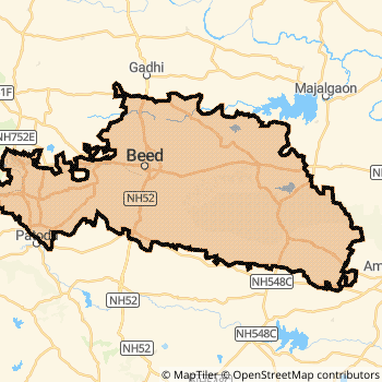
Beed District Map
Current Corona Virus Infected Patients Count in Beed District
| City Name | District Name | Total Covid cases |
|---|
Beed Live Weather
Temperature: 17.6 °C
clear sky
Humidity: 53%
Wind : 1.14 mt/sec towards E
StationName : "Gevrai"
observed on 2 Hours Back
Temperature: 17.6 °C
clear sky
Humidity: 53%
Wind : 1.14 mt/sec towards E
StationName : "Gevrai"
observed on 2 Hours Back
Beed Weather Forecast for Next 5 days
04-01-2026
20.0°C to 29.2°C
clear sky
20.0°C to 29.2°C
clear sky
05-01-2026
18.7°C to 29.5°C
clear sky, few clouds, scattered clouds
18.7°C to 29.5°C
clear sky, few clouds, scattered clouds
06-01-2026
18.2°C to 28.4°C
scattered clouds, clear sky
18.2°C to 28.4°C
scattered clouds, clear sky
07-01-2026
17.2°C to 28.8°C
clear sky
17.2°C to 28.8°C
clear sky
08-01-2026
16.3°C to 28.9°C
few clouds, scattered clouds, clear sky, broken clouds
16.3°C to 28.9°C
few clouds, scattered clouds, clear sky, broken clouds
Temples in Beed
Ambe Jogai
Ambe Jogai
Historical Daily Max Temperatures (Next 7 Days)
| Years | 02 Jan | 03 Jan | 04 Jan | 05 Jan | 06 Jan | 07 Jan | 08 Jan |
|---|---|---|---|---|---|---|---|
| 2025 | |||||||
| 2024 | |||||||
| 2023 |
About Beed District
Beed District is one among 34 Districts of Maharashtra State ,India. It belongs to Marathwada Region . Beed District Administrative head quarter is Beed. It is is Located 356 KM west towards State capital Mumbai . Beed District population is 2585962. It is 18 th Largest District in the State by population.Geography and Climate Beed District
It is Located at Latitude-18.9, Longitude-75.7. Beed District is sharing border with Ahmednagar District to the west , Jalna District to the North , Latur District to the East , Osmanabad District to the South , Parbhani District to the East . Beed District occupies an area of approximately 10693 square kilometres. . Its in the 674 meters to 407 meters elevation range.This District belongs to Western India .DemoGraphics of Beed District
English is the Local Language here. Also People Speaks Hindi, Marathi . Beed District is divided into 11 Talukas , Panchayats , 1434 Villages.Major producing Items,Crops,Industries and Exports from Beed District
Bajara, BajaraJowar, BajaraJowartur, BajaraJowazr, BajaraTur, BajaraTurWhea, BajaraVe, Table, BajaraWheat, Bajari, BajariTur, Bajra, BajraJowar, BajraTur, BajraTurJowar, BajraWheat, BajraWheatTur, Bri are the major producing Items and Exports from here.Census 2011 of Beed District
Beed district Total population is 2585962 according to census 2011.Males are 1352491 and Females are 1233471 .Literate people are 1710872 among total.Its total area is 10693 sq.km. It is the 18 th largest district in the state by Population . But 9 th Largest District in the state By Area. 159 th Largest District in the Country By Population. 32 nd highest District in the State By literacy rate. 301 st highest District in the Country By literacy rate.its literacy Rate is 73.53Politics in Beed District
Bharatiya Janata Party , BJP , NCP are the major political parties in Beed District.Assembly constituencies in Beed District
Total 6 Assembly constituencies in Beed District.| Constituency name | MLA name | Party |
|---|---|---|
| Georai | Laxman Madhavrao Pawar | BJP |
| Majalgaon | Prakash (Dada) Sundarrao Solanke | NCP |
| Beed | Sandeep Ravindra Kshirsagar | NCP |
| Ashti | Ajabe Balasaheb Bhausaheb | NCP |
| Kaij | Namita Akshay Mundada | BJP |
| Parli | Dhananjay Panditrao Munde | NCP |
Parliament constituencies in Beed District
Total 1 Parliament constituencies in Beed District.| Constituency name | MP name | Party |
|---|---|---|
| Beed | Pritam Gopinathrao Munde | Bharatiya Janata Party |
Beed District Political Map
Beed Commerce
Total Registered Comapnies with Ministry of Corporate Affairs (MCA) in Beed are 506Company Name : MAHARASHTRA SHETKARI SUGAR LIMITED
Type Of Business : Manufacturing (Food stuffs)
Capital : 79.8539 Crores
Company Name : JAY MAHESH SUGAR INDUSTRIES LIMITED
Type Of Business : Manufacturing (Food stuffs)
Capital : 29.837 Crores
Company Name : TIRUMALLA OIL REFINERY PRIVATE LIMITED
Type Of Business : Manufacturing (Food stuffs)
Capital : 25.0 Crores
Company Name : FDC LIMITED
Type Of Business : Manufacturing (Metals & Chemicals; and products thereof)
Capital : 17.8619 Crores
More Beed Registered Companies
Beed District Tourism
Temples in Beed District
Ambe Jogai are the famous temple in Beed DistrictBeed Transport
Road Transport
District Headquarters Beed is well connected by road . Manjlegaon , Parli are the Cities in this district having road connectivity to major towns and remote villages. Beed is about 356 KM by road to Mumbai( Capital of Maharashtra )Rail Transport
Some of the rail way stations in district are Parli Vaijnath , Ukhali , Ghat Nandur .... which connects most of the towns and villages in the District.Bus Transport
Maharashtra State Road Transportation ( MSRTC) runs Busses from Major cities to Towns and Villages in this District.
Pin Codes in Beed District
431122
( Beed ) ,
431520
( Parli Tps ) ,
431107
( Paithan ) ,
431125
( Naiknoor ) ,
413229
( Pimpalwandi (Beed)) ,
431126
( Chousala ) ,
431110
( Raghunath Nagar (Aurangabad)) ,
431111
( Phulmbri ) ,
431116
( Shivar ) ,
431123
( Kaij ) ,
414202
( Kada (Beed)) ,
431124
( Kille Dharur ) ,
431128
( Dindrood ) ,
431148
( Paithan Sakhar Karkhana ) ,
431129
( Talkhed ) ,
414204
( Patoda (Beed)) ,
413207
( Amalner (Beed)) ,
431130
( Umapur ) ,
431519
( Ghatnandur ) ,
431127
( Gevrai ) ,
more PinCodes
Hotels in Beed
Anvita Hotel
Jaina Road, Beed - 431122, India
Beed
Contact No: 02442 - 224702
Price Range : Rs. 800 - Rs. 1900
BusStops in Beed Lakes in Beed Temples in Beed Shops in Beed Beed Hospitals Hotel/Restaurants in Beed Beed RailwayStations Beed BusStops ATM in Beed
Near Cities
Manjlegaon 58 KM near
Pathardi 72 KM near
Paithan 74 KM near
Pathri 85 KM near
Near By Air Ports
Latur Airport 110 KM near
Chikkalthana Airport 117 KM near
Sholapur Airport 170 KM near
Nanded Airport 184 KM near
Near By Districts
Beed 0 KM near
Osmanabad 105 KM near
Jalna 107 KM near
Latur 121 KM near