| Home | City Bus | Maps | Villages | Cities | Rail | Tourist Places | School | College | Pin Codes | Corona Cases Count |
| Distance Calculator Bus Services IFSC Codes Trace Mobile Number Weather Search Place Trace IP Available Cash ATM/Banks Locate Polling Booth Report an Error contact People |
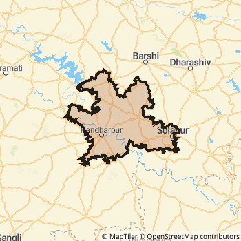
Solapur District.
Currently In:
India >>
Maharashtra
Region : Desh or Paschim Maharashtra
Division : Pune
Head Quarters : Solapur
Language : Marathi and Kannada, Telugu, Urdu
Area: 14845 sq. km
Population : 4315527
Sex Ratio : 932
Density : 290/ sq. km
Literacy : 77.72
Elevation / Altitude: 552 - 457 meters. Above Seal level
Current Time 02:16 PM
Date: Friday , Jan 02,2026 (IST)
Time zone: IST (UTC+5:30)
District Pin code Index: 413XXX
Vehicle Registration Number: MH-13,MH-45
RTO Office: Akluj,Solapur
Solapur District Map
Current Corona Virus Infected Patients Count in Solapur District
| City Name | District Name | Total Covid cases |
|---|---|---|
| Solapur District | Solapur | 7 |
Solapur Live Weather
Temperature: 29.4 °C
clear sky
Humidity: 31%
Wind : 1.99 mt/sec towards SW
StationName : "Solapur"
observed on 41 Mins Back
Temperature: 29.4 °C
clear sky
Humidity: 31%
Wind : 1.99 mt/sec towards SW
StationName : "Solapur"
observed on 41 Mins Back
Solapur Weather Forecast for Next 5 days
03-01-2026
21.6°C to 30.1°C
clear sky, few clouds
21.6°C to 30.1°C
clear sky, few clouds
04-01-2026
20.5°C to 30.6°C
few clouds, clear sky, scattered clouds
20.5°C to 30.6°C
few clouds, clear sky, scattered clouds
05-01-2026
21.1°C to 29.9°C
few clouds, broken clouds, clear sky
21.1°C to 29.9°C
few clouds, broken clouds, clear sky
06-01-2026
20.2°C to 29.9°C
broken clouds, scattered clouds, clear sky
20.2°C to 29.9°C
broken clouds, scattered clouds, clear sky
07-01-2026
18.6°C to 29.5°C
scattered clouds, clear sky
18.6°C to 29.5°C
scattered clouds, clear sky
Temples in Solapur
Akkalkot Swami Samarth Vithoba Temple Shri Swami Samarth Samadhi Mandir, Vishnupaad Temple Pundalik Temple
Akkalkot Swami Samarth Vithoba Temple Shri Swami Samarth Samadhi Mandir, Vishnupaad Temple Pundalik Temple
Historical Daily Max Temperatures (Next 7 Days)
| Years | 02 Jan | 03 Jan | 04 Jan | 05 Jan | 06 Jan | 07 Jan | 08 Jan |
|---|---|---|---|---|---|---|---|
| 2025 | |||||||
| 2024 | |||||||
| 2023 |
About Solapur District
Solapur District is one among 34 Districts of Maharashtra State ,India. It belongs to Desh or Paschim Maharashtra Region . Solapur District Administrative head quarter is Solapur. It is is Located 416 KM west towards State capital Mumbai . Solapur District population is 4315527. It is 7 th Largest District in the State by population.Geography and Climate Solapur District
It is Located at Latitude-17.6, Longitude-75.9. Solapur District is sharing border with Ahmednagar District to the North , Osmanabad District to the North , Pune District to the west , Sangli District to the west . Solapur District occupies an area of approximately 14845 square kilometres. . Its in the 552 meters to 457 meters elevation range.This District belongs to Western India .DemoGraphics of Solapur District
Marathi is the Local Language here. Also People Speaks Kannada, Telugu, Urdu . Solapur District is divided into 11 Talukas , Panchayats , 2108 Villages.Major producing Items,Crops,Industries and Exports from Solapur District
Banana, Blanketas, Colour, Steel, , Cottan, Jawar, Cottan, Sugarcan, Fruitbox, Grain, Grossary, GrapeProd, Grapes, Grossary, Handloom, Jaggary, Jawar, Jawar, Bajari, Jawar, Wheat, Kum-Kum, Kumkum, Man are the major producing Items and Exports from here.Census 2011 of Solapur District
Solapur district Total population is 4315527 according to census 2011.Males are 2233710 and Females are 2081817 .Literate people are 2855153 among total.Its total area is 14845 sq.km. It is the 7 th largest district in the state by Population . But 4 th Largest District in the state By Area. 43 rd Largest District in the Country By Population. 25 th highest District in the State By literacy rate. 205 th highest District in the Country By literacy rate.its literacy Rate is 77.72Politics in Solapur District
Bharatiya Janata Party , PWPI , BJP , NCP , Shivsena , INC , SHS are the major political parties in Solapur District.Assembly constituencies in Solapur District
Total 11 Assembly constituencies in Solapur District.| Constituency name | MLA name | Party |
|---|---|---|
| Karmala | Sanjaymama Vitthalrao Shinde | IND |
| Madha | Shinde Babanrao Vitthalrao | NCP |
| Barshi | Rajendra Vitthal Raut | IND |
| Mohol | Mane Yashwant Vitthal | NCP |
| Solapur City North | Deshmukh Vijaykumar Sidramappa | BJP |
| Solapur City Central | Shinde Praniti Sushilkumar | INC |
Parliament constituencies in Solapur District
Total 3 Parliament constituencies in Solapur District.| Constituency name | MP name | Party |
|---|---|---|
| Osmanabad | Omprakash Bhupalsinh Alias Pawan Rajenimbalkar | Shivsena |
| Madha | Ranjeetsinha Hindurao Naik- Nimbalkar | Bharatiya Janata Party |
| Solapur | SHRI. SHA. BRA. DR. JAI SIDHESHWAR SHIVACHARY MAHA | Bharatiya Janata Party |
Solapur District Political Map
Solapur Commerce
Total Registered Comapnies with Ministry of Corporate Affairs (MCA) in Solapur are 1446Company Name : LOKMANGAL SUGAR ETHENOL & CO-GENERATION INDUSTRIES LIMITED
Type Of Business : Manufacturing (Metals & Chemicals; and products thereof)
Capital : 139.56 Crores
Company Name : LOKMANGAL MAULI INDUSTRIES LIMITED
Type Of Business : Manufacturing (Food stuffs)
Capital : 104.117 Crores
Company Name : LOKMANGAL AGRO INDUSTRIES LIMITED
Type Of Business : Agriculture and Allied Activities
Capital : 99.9667 Crores
Company Name : PRECISION CAMSHAFTS LIMITED
Type Of Business : Manufacturing (Metals & Chemicals; and products thereof)
Capital : 94.8766 Crores
More Solapur Registered Companies
Solapur District Tourism
Pandharpur , Solapur , Vitthal Temple , Rukmini Temple , Vithoba Temple , Vishnupad Temple , PANDHARPUR, AKKALKOT , Pundalik Temple , Rukmini Mandir , Trimbakeshwar Temple , Siddheshwar Temple , are the Tourist destinations to Visit.
Temples in Solapur District
Akkalkot Swami Samarth , Vithoba Temple , Shri Swami Samarth Samadhi Mandir, , Vishnupaad Temple , Pundalik Temple are the famous temple in Solapur DistrictSolapur Transport
Road Transport
District Headquarters Solapur is well connected by road . Solapur , Mangalvedhe , Pandharpur , Sangole are the Cities in this district having road connectivity to major towns and remote villages. Solapur is about 416 KM by road to Mumbai( Capital of Maharashtra )Rail Transport
Some of the rail way stations in district are Solapur , Kurduvadi Junction , Hotgi Junction , Jeur , Pandharpur , Barsi Town , Sangola , Modnimb .... which connects most of the towns and villages in the District.Bus Transport
Maharashtra State Road Transportation ( MSRTC) runs Busses from Major cities to Towns and Villages in this District.
Pin Codes in Solapur District
413220
( Dudhani ) ,
413223
( Kem ) ,
413212
( Bhimanagar ) ,
413222
( Nanaj (Solapur)) ,
413224
( Shivshahi ) ,
413411
( K.V.Nagar Barshi ) ,
413213
( Mohol ) ,
413410
( Manegaon ) ,
413309
( Jawala (Solapur)) ,
413221
( Mandrup ) ,
413402
( Vairag ) ,
413118
( Yeshwantnagar (Solapur)) ,
413113
( Velapur ) ,
413007
( Solapur City ) ,
413109
( Natepute ) ,
413211
( Tembhurni (Solapur)) ,
413112
( Shreepur ) ,
413304
( Pandharpur ) ,
413303
( Ashti (Solapur)) ,
413314
( Kole (Solapur)) ,
more PinCodes
Hotels in Solapur
Mayura Hotel
99, Shivaji Chowk, Budhwar Peth, Solapur - 413001, India
Solapur
Contact No: 0217-2322000
Price Range : Rs. 400 - Rs. 700
Aishwarya Hotel
Hotel Aishwarya,125, Murarji Peth, Solapur - 413001, India
Solapur
Contact No: 98500 37970
Price Range : Rs. 600 - Rs. 1000
Ritesh Hotel
184,, Golfinch Peth, Solapur - 413007, India
Solapur
Contact No: 0217-2622383
Price Range : Rs. 400 - Rs. 800
Shivparvati International Hotel
220/221-B; Goldfinch Peth; Subhash Chowk (Lucky); Solapur Dist.; Maharashtra
Solapur
Price Range : Rs. 800 - Rs. 1300
BusStops in Solapur Lakes in Solapur Temples in Solapur Shops in Solapur Solapur Hospitals Hotel/Restaurants in Solapur Solapur RailwayStations Solapur BusStops ATM in Solapur
Near Cities
Solapur 2 KM near
Tuljapur 47 KM near
Mangalvedhe 57 KM near
Osmanabad 66 KM near
Near By Air Ports
Sholapur Airport 4 KM near
Latur Airport 114 KM near
Kolhapur Airport 224 KM near
Nanded Airport 252 KM near
Near By Districts
Solapur 0 KM near
Osmanabad 68 KM near
Bijapur District 105 KM near
Gulbarga 116 KM near