| Home | City Bus | Maps | Villages | Cities | Rail | Tourist Places | School | College | Pin Codes | Corona Cases Count |
| Distance Calculator Bus Services IFSC Codes Trace Mobile Number Weather Search Place Trace IP Available Cash ATM/Banks Locate Polling Booth Report an Error contact People |
Purulia District.
Currently In:
India >>
West Bengal
Division : Burdwan
Head Quarters : Purulia
Language : Bengali and English
Area: 6259 sq. km
Population : 2927965
Sex Ratio : 955
Density : 468/ sq. km
Literacy : 65.38
Elevation / Altitude: 312 - 129 meters. Above Seal level
Current Time 07:46 AM
Date: Thursday , Jan 01,2026 (IST)
Time zone: IST (UTC+5:30)
District Pin code Index: 723XXX
Vehicle Registration Number: WB-55,WB-56
RTO Office: Purulia
Tourist Places near Purulia
Purulia (Manbhum City) Bokaro Steel City Dhanbad Jamshedpur Maithan Bankura
Purulia (Manbhum City) Bokaro Steel City Dhanbad Jamshedpur Maithan Bankura
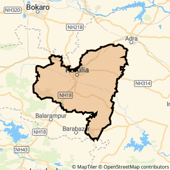
Purulia District Map
Current Corona Virus Infected Patients Count in Purulia District
| City Name | District Name | Total Covid cases |
|---|
Purulia Live Weather
Temperature: 14.0 °C
clear sky
Humidity: 32%
Wind : 0.89 mt/sec towards W
StationName : "Puruliya"
observed on 31 Mins Back
Temperature: 14.0 °C
clear sky
Humidity: 32%
Wind : 0.89 mt/sec towards W
StationName : "Puruliya"
observed on 31 Mins Back
Purulia Weather Forecast for Next 5 days
02-01-2026
13.3°C to 25.7°C
clear sky
13.3°C to 25.7°C
clear sky
03-01-2026
12.4°C to 26.0°C
clear sky, few clouds
12.4°C to 26.0°C
clear sky, few clouds
04-01-2026
13.4°C to 26.1°C
clear sky
13.4°C to 26.1°C
clear sky
05-01-2026
12.9°C to 26.0°C
clear sky
12.9°C to 26.0°C
clear sky
06-01-2026
12.4°C to 25.2°C
clear sky
12.4°C to 25.2°C
clear sky
Temples in Purulia
Historical Daily Max Temperatures (Next 7 Days)
| Years | 31 Dec | 01 Jan | 02 Jan | 03 Jan | 04 Jan | 05 Jan | 06 Jan |
|---|---|---|---|---|---|---|---|
| 2025 | |||||||
| 2024 | 18.0°C/ 15.0°C | ||||||
| 2023 | 25.0°C/ 15.0°C | ||||||
| 2022 | 26.0°C/ 13.0°C |
About Purulia District
Purulia District is one among 19 Districts of West Bengal State ,India. Purulia District Administrative head quarter is Purulia. It is is Located 258 KM East towards State capital Kolkata . Purulia District population is 2927965. It is 16 th Largest District in the State by population.Geography and Climate Purulia District
It is Located at Latitude-23.3, Longitude-86.3. Purulia District is sharing border with Bokaro District to the North , Dhanbad District to the North , East Singhbum District to the South , Ranchi District to the west , Saraikela Kharsawan District to the South , Bankura District to the East , Bardhaman District to the East . It is sharing Border with Jharkhand State to the west . Purulia District occupies an area of approximately 6259 square kilometres. . Its in the 312 meters to 129 meters elevation range.This District belongs to Eastern India .DemoGraphics of Purulia District
Bengali is the Local Language here. Also People Speaks English . Purulia District is divided into 22 Blocks , Panchayats , 184 Villages.Census 2011 of Purulia District
Purulia district Total population is 2927965 according to census 2011.Males are 1497680 and Females are 1430285 .Literate people are 1937142 among total.Its total area is 6259 sq.km. It is the 16 th largest district in the state by Population . But 5 th Largest District in the state By Area. 128 th Largest District in the Country By Population. 17 th highest District in the State By literacy rate. 482 nd highest District in the Country By literacy rate.its literacy Rate is 65.38Politics in Purulia District
CPM , Bharatiya Janata Party , AITC , AIFB , INC are the major political parties in Purulia District.Assembly constituencies in Purulia District
Total 11 Assembly constituencies in Purulia District.| Constituency name | MLA name | Party |
|---|---|---|
| Bandwan | Rajib Lochan Saren | AITC |
| Balarampur | Baneswar Mahato | AITC |
| Baghmundi | Sushanta Mahato | INC |
| Joypur | Nara Hari Mahato | AITC |
| Purulia | Sudip Kumar Mukherjee | INC |
| Manbazar | Sandhyarani Tudu | AITC |
Parliament constituencies in Purulia District
Total 3 Parliament constituencies in Purulia District.| Constituency name | MP name | Party |
|---|---|---|
| Purulia | JYOTIRMAY SINGH MAHATO | Bharatiya Janata Party |
| Jhargram | Kunar Hembram | Bharatiya Janata Party |
| Bankura | DR. SUBHAS SARKAR | Bharatiya Janata Party |
Purulia District Political Map
Purulia Commerce
Total Registered Comapnies with Ministry of Corporate Affairs (MCA) in Purulia areMore Purulia Registered Companies
Purulia District Tourism
Purulia , are the Tourist destinations to Visit.
Purulia Transport
Road Transport
District Headquarters Purulia is well connected by road . Kulti , Chirkunda , Purulia , Adra, Purulia , Barakar are the Cities in this district having road connectivity to major towns and remote villages. Purulia is about 258 KM by road to Kolkata( Capital of West Bengal )Rail Transport
Some of the rail way stations in district are Adra Junction , Purulia Junction , Joychandi Pahar Junction , Burnpur , Anara , Jhalida , Barabhum , Barakar .... which connects most of the towns and villages in the District.Bus Transport
West Bengal Surface Transport Corporation ( WBSTC) runs Busses from Major cities to Towns and Villages in this District.
Hotels in Purulia
New Raj Palace Hotel
Opposite Indian Overseas Bank, Bye Pass Road, Bokaro, Jharkhand, India-827013
Bokaro
Contact No: (91)-9431162303, 9431521557
Price Range : Rs. 400 - Rs. 1300
Nirmala Hotel
Near Dharmashala Chowk, Main Road, Bokaro - 827013
Bokaro
Contact No: (91)-9334220611
Price Range : Rs. 400 - Rs. 600
Avtar Hotel
Near Garga Bridge,, Bokaro, Jharkhand, India-827013
Bokaro
Contact No: (91)-9608566480, 9304346933
Price Range : Rs. 450 - Rs. 1000
Casablanca Hotel
Bye Pass Road, Chas Bokaro Steel City - 827013
Bokaro
Contact No: 9798800434, 9534035805
Email: hotel.casaaablanca@ymail.com
Price Range : Rs. 750 - Rs. 1700
Near Cities
Purulia 24 KM near
Adra, Purulia 40 KM near
Raghunathpur 43 KM near
Bokaro Steel City 49 KM near
Near By Air Ports
Ranchi Airport 119 KM near
Gaya Airport 239 KM near
Netaji Subhas Chandra Bose Airport 252 KM near
Patna Airport 317 KM near
Near By Districts
Purulia 0 KM near
Bokaro 50 KM near
Dhanbad 58 KM near
East Singhbum 69 KM near