| Home | City Bus | Maps | Villages | Cities | Rail | Tourist Places | School | College | Pin Codes | Corona Cases Count |
| Distance Calculator Bus Services IFSC Codes Trace Mobile Number Weather Search Place Trace IP Available Cash ATM/Banks Locate Polling Booth Report an Error contact People |
Head Quarters : Gumla
Language : Nagpuri and Hindi, Oriya, Bihari, Kurukh.
Area: 5327 sq. km
Population : 1025656
Sex Ratio : 993
Density : 193/ sq. km
Literacy : 66.92
Elevation / Altitude: 694 - 452 meters. Above Seal level
Current Time 01:38 PM
Date: Friday , Jan 02,2026 (IST)
Time zone: IST (UTC+5:30)
District Pin code Index: 835XXX
Vehicle Registration Number: JH-07
RTO Office: Gumla
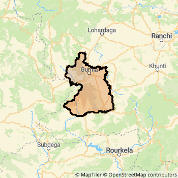
Gumla District Map
Current Corona Virus Infected Patients Count in Gumla District
| City Name | District Name | Total Covid cases |
|---|
Gumla Live Weather
Temperature: 23.9 °C
few clouds
Humidity: 26%
Wind : 4.58 mt/sec towards NW
StationName : "GumlÄ\u0081"
observed on 5 Mins Back
Temperature: 23.9 °C
few clouds
Humidity: 26%
Wind : 4.58 mt/sec towards NW
StationName : "GumlÄ\u0081"
observed on 5 Mins Back
Gumla Weather Forecast for Next 5 days
03-01-2026
11.1°C to 24.4°C
scattered clouds, few clouds, clear sky
11.1°C to 24.4°C
scattered clouds, few clouds, clear sky
04-01-2026
10.7°C to 24.3°C
few clouds, clear sky
10.7°C to 24.3°C
few clouds, clear sky
05-01-2026
9.8°C to 25.2°C
clear sky
9.8°C to 25.2°C
clear sky
06-01-2026
9.0°C to 24.0°C
clear sky
9.0°C to 24.0°C
clear sky
07-01-2026
8.2°C to 24.1°C
clear sky
8.2°C to 24.1°C
clear sky
Temples in Gumla
Historical Daily Max Temperatures (Next 7 Days)
| Years | 02 Jan | 03 Jan | 04 Jan | 05 Jan | 06 Jan | 07 Jan | 08 Jan |
|---|---|---|---|---|---|---|---|
| 2025 | |||||||
| 2024 | |||||||
| 2023 |
About Gumla District
Gumla District is one among 24 Districts of Jharkhand State ,India. Gumla District Administrative head quarter is Gumla. It is is Located 99 KM East towards State capital Ranchi . Gumla District population is 1025656. It is 16 th Largest District in the State by population.Geography and Climate Gumla District
It is Located at Latitude-23.0, Longitude-84.5. Gumla District is sharing border with Jashpur District to the west , Khunti District to the East , Lohardaga District to the North , Ranchi District to the East , Simdega District to the South . It is sharing Border with Chattisgarh State to the west . Gumla District occupies an area of approximately 5327 square kilometres. . Its in the 694 meters to 452 meters elevation range.This District belongs to Hindi Belt India .DemoGraphics of Gumla District
Nagpuri is the Local Language here. Also People Speaks Hindi, Oriya, Bihari, Kurukh. . Gumla District is divided into 11 Blocks , 150 Panchayats , 1910 Villages. Bishunpur Block is the Smallest Block by population with 49873 population. Gumla Block is the Biggest Block by population with 165508 population.Census 2011 of Gumla District
Gumla district Total population is 1025656 according to census 2011.Males are 514629 and Females are 511027 .Literate people are 678574 among total.Its total area is 5327 sq.km. It is the 16 th largest district in the state by Population . But 3 rd Largest District in the state By Area. 434 th Largest District in the Country By Population. 11 th highest District in the State By literacy rate. 455 th highest District in the Country By literacy rate.its literacy Rate is 66.92Politics in Gumla District
Bharatiya Janata Party , BJP , JMM , JKP , INC are the major political parties in Gumla District.Assembly constituencies in Gumla District
Total 4 Assembly constituencies in Gumla District.| Constituency name | MLA name | Party |
|---|---|---|
| Sisai | JIGA SUSARAN HORO | JMM |
| Gumla | BHUSHAN TIRKEY | JMM |
| Bishunpur | CHAMRA LINDA | JMM |
| Simdega | BHUSHAN BARA | INC |
Parliament constituencies in Gumla District
Total 2 Parliament constituencies in Gumla District.| Constituency name | MP name | Party |
|---|---|---|
| Khunti | ARJUN MUNDA | Bharatiya Janata Party |
| Lohardaga | SUDARSHAN BHAGAT | Bharatiya Janata Party |
Gumla District Political Map
Gumla Commerce
Total Registered Comapnies with Ministry of Corporate Affairs (MCA) in Gumla are 81Company Name : RMSV CONSTRUCTION PRIVATE LIMITED
Type Of Business : Construction
Capital : 30.0 Lakhs
Company Name : IMANSION MUTUAL BENEFIT LIMITED
Type Of Business : Finance
Capital : 15.0 Lakhs
Company Name : GREEN NATURAL AYURVED (OPC) PRIVATE LIMITED
Type Of Business : Manufacturing (Metals & Chemicals, and products thereof)
Capital : 10.0 Lakhs
Company Name : RANISATI DWELLERS PRIVATE LIMITED
Type Of Business : Construction
Capital : 10.0 Lakhs
More Gumla Registered Companies
Gumla District Tourism
Gumla , Panch Pandava Pahar , Tanginath , Mahadev Kona , Rajadera , Taraloya Waterfalls , Devaki , Basudeokona , are the Tourist destinations to Visit.
Gumla Transport
Road Transport
District Headquarters Gumla is well connected by road . Gumla is about 99 KM by road to Ranchi( Capital of Jharkhand )Rail Transport
Some of the rail way stations in district are Kurkura , Pakra .... which connects most of the towns and villages in the District.Bus Transport
Pin Codes in Gumla District
835233
( Toto ) ,
835220
( Palkot ) ,
835206
( Chainpur (Gumla)) ,
835208
( Ghaghra ) ,
835324
( Sisai (Gumla)) ,
835229
( Basia ) ,
835232
( Nawagarh (Gumla)) ,
835231
( Bishunpur ) ,
835203
( Bharno ) ,
835230
( Noadih ) ,
835207
( Gumla ) ,
835306
( Bhandra) ,
more PinCodes
Hotels in Gumla
Santosh Rest House
Palkot Road,Tower Chowk, Main Road Gumla - 835207, India
Gumla
Contact No: 06524 - 223462
Price Range : Rs. 200 - Rs. 200
Bindesh Hotel
114, Lohardaga Road, Gumla- 835207
Gumla
Contact No: (6524) 223789, (6524) 224778
Price Range : Rs. 400 - Rs. 900
BusStops in Gumla Lakes in Gumla Temples in Gumla Shops in Gumla Gumla Hospitals Hotel/Restaurants in Gumla Gumla RailwayStations Gumla BusStops ATM in Gumla
Near Cities
Gumla 0 KM near
Jashpurnagar 48 KM near
Lohardaga 50 KM near
Simdega 54 KM near
Near By Air Ports
Ranchi Airport 95 KM near
Gaya Airport 216 KM near
Patna Airport 323 KM near
Varanasi Airport 354 KM near
Near By Districts
Gumla 0 KM near
Lohardaga 50 KM near
Jashpur 50 KM near
Simdega 54 KM near