Shillong
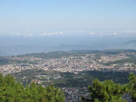
The capital city of the Indian state of Meghalaya is located in the hill city of Shillong. The city is located in the north eastern portion of the country, India. The height of the town of Shillong is 1496 meters above the sea level. Prior to the construction of the state of Meghalaya, which took place in the year 1974, Shillong used to serve as the capital of the Indian state of Assam.
This location creates a perfect location for vacation owing to its people, the location and the weather condition. In and around Shillong there are numerous beautiful and intriguing locations to see. This hill station is quite a famous spot. The title of ‘Scotland of East’ is given to Shillong by the British people.
TOURIST PLACES IN SHILLONG
Shillong Peak: The altitude of the peak is 1,965 meters and is set at a distance of 10 Kms from Shillong city. One can obtain a spectacular site of the whole city of Shillong. This spot is also regarded as the most altitudinous location in the Indian state of Meghalaya.
Sohpetbneng Peak: The distance between the Sohpetbneng Peak and Shillong is 20 Kms. The altitude of the peak is 1,343 meters from the sea level.
Ward's Lake: The Ward’s lake is a spectacular site of beauty, which dates back to almost a century. This lake is situated right in the middle of the city. The name ‘Nan Polok’ is given to this lake by the native people. The name has been derived from the name of an executive engineer
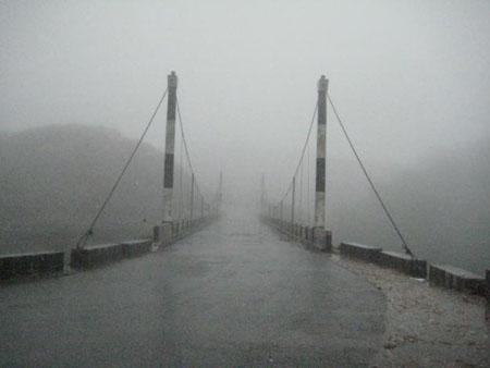
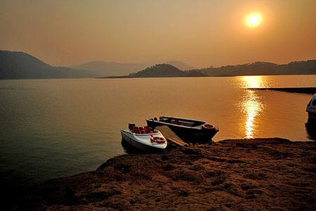
Umiam Water Sports Complex: Right on the majestic reservoir of the Umian Hydro Electric Project at Umiam, the Umiam Water Sports Complex is located. This location is situated at a distance of 16 Kms from Shillong.
Botanical Garden: The Botanical Garden has an overabundance of many varieties rare flowers. One can also observe many kinds of vibrant birds.
Lady Hydari Park: The area of the park is as much as 1 square Kilometer. The park is full of plush blooming roses and other flowers of different vibrant colors. The origin of the park is traced back to Lady Hydari, who is the wife of the then Governor of Assam. One can also see a mini zoo plus a deer park here.
Golf Course: In the United States Golf Association Museum, the title of ‘Glen-eagle of the East’ is given to the Shillong Golf Course. The altitude of the location is 5200 feet. The origin of the golf course was in the year 1898. Then the golf course was a 9 holes course. Later in the year 1924, this course was transformed into a 18 holes course. Captain Jackson and C.K Rhodes made this transformation.
State Museum: On the grounds of the central library, the State Museum is situated. The museum houses collectibles from the North Eastern India and also particularly from the Indian state of Meghalaya.
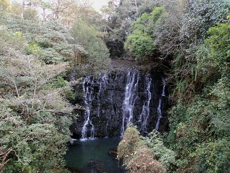
Elephant Falls: The Elephant falls is located at a distance of 12 Kms on the outer edge of the city. In order to make the two smaller falls accessible for the visitors, there is a well maintained footpath and a little bridge made out of wood. The names of the two smaller falls are Wei Iaplam Falls and the Wir Phang Falls.
Spread Eagle Falls: The Spread Eagle Falls is situated inside the boundaries of the Shillong Cantonment area. The waterfall is in the shape of an eagle spreading its wings.
Sweet Falls: The distance between Shillong and the Sweet Falls is a mere 8 Kms. It is located close to the Happy Valley. The height from which the water drops is more than 200 feet.
Crinoline Falls: Neighboring the lady Hydari Park, Crinoline Falls is situated right in the middle of the city. A properly preserved swimming pool is located at the base of the water falls.
Diengiei Peak: The Diengiei Peak is situated on the west direction of the Shillong Plateau. The altitude of the Diengiei Peak is 200 less than the altitude of the Shillong Peak. One can observe a concave shaped hollow structure on Diengiei. It is considered to be a crater of a dead archaic volcano.
Dwarksuid: Dwarksuid is a spectacular and pretty pool situated on a stream, which is located beside the Umroi Bhoilymbong Road. The pool has nice wide expanse of rocky and sandy beds.
Kyllang Rock: The distance between Mairang and this place is a mere 11 Kms. This location is famous for the dome like structure made of red granite. The altitude of the structure is 5400 feet above the sea level. The existence of this dome can be traced back to several million years.
Cherrapunjee (Sohra): Sohra is another name by which Cherrapunji is known as. The distance between Cherrapunji and Shillong is 56 Kms. The altitude of the place is 1300 meters above the sea level. Some of the main attractions to see in Cherrapunji are the majestic waterfalls such as the renowned Nohsngithiang waterfall, the caves made of limestone, the orange orchards etc.
Noh Kalikai Falls: This spectacular and mesmerizing waterfall is located at a distance of a couple of kilometers from the west direction of Sohra.
Kshaid Dain Thlen Falls: This place is situated close to Sohra. As per beliefs, this is the location, where the butchering of the head of the legendary monster of Khasi myth took place.
Mawsynram: The distance of Mawsynram and Shillong is 56 Kms. The presence of the “Shivalinga”, which is basically an enormous formation of stalagmite, has made this place quite famous. This huge shape is present within a cave. The name of the cave is ‘Mawsymbuin’.
Jakrem: The distance between Jakrem and Shillong is 64 Kms.
Ranikor: The distance between Ranikor and Shillong is 140 Kms. The town is full of spectacular natural beauty. Some of the activities for which this place is quite famous are angling and fishing.
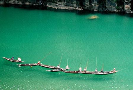
Dawki: The distance between Dawki and Shillong is 96 Kms. This town is located near the boundary between India and Bangladesh. One of enjoyable feature of this town is the yearly boat race that takes place during the spring time in the river named Umngot.
Nongkhnum island: In the Indian state of Meghalaya, Nongkhnum Island is considered to be the largest river island. It also ranks second in the same category in the entire Asia continent; Majuli Island of Assam being the first. The distance between this island and Nongstoin is 14 Kms. The area of the island measures to 20 to 25 square kilometers.
Tourist Places in Jaintia Hills
Jowai: The administrative headquarters of the district of Jaintia Hills is located in Jowai. The distance between the town of Jowai and the National Highway is 64 Kms. The river name Myntdu encloses this beautiful town.
Thadlaskein Lake: The distance between this lake and Shillong is 56 Kms.
Megalithic Remnants- Nartiang: The distance between this summer capital of the Jaintia Kings and Shillong is 65 Kms. The village is dotted with enormous monoliths. The width of the Nartiang Menhir is 27.5 feet.
Syntu Ksiar: At the location, where Jowai is almost enclosed by the river named Myntdu, a huge expanse of pacified water is present. This water body is called Syntu Ksiar. The word ‘Syntu Ksiar’ stands for ‘Golden Flower’.
Tourist Places in Garo Hills
Nokrek Peak: Nokrek Peak is the most altitudinous location of the Garo Hills area of the Indian state of Meghalaya. The altitude of the peak is 1412 meters above the sea level. Inside the region of the Nokrek Range, science researchers have found the mother germo plasm of Citrus-indica. Owing to this discovery, the National CitrusGene Sanctuary-cum-Biosphere Reserve was constructed in Nokrek. The area of this construction is 47 sq. Kilometers.
Tura Peak: On the eastern side of Tura, one can see the mighty hill. The altitude of the hill is 872 meters from the sea level. On the peak of Tura one can find a tourist bungalow, an observatory and also a plantation of Cinchona.
Imilchang Dare: On the Tura-Chokpot road, which is situated in the district named West Garo, the Imilchang Dare is situated. The spectacular pool, which is situated at the base of the water fall is a must see. The pool has got nice depth and width, thus making it a good place for swimming.
Balpakram: The distance between Balpakram and Tura is 167 Kms. This place is situated in the South Garo Hills. It is a National Wildlife Park. One can observe the rare species of Lesser Panda, the Indian bison and the Stag like Serow. Numerous types of herbs having medicinal properties can also be found in great quantities here.
Naphak Lake: The distance between Tura and Naphak Lake is 112 Kms. This location is perfect for activities like fishing and also watching birds. Close to this place, one can see the river named Simsang flowing.
Caves in Khasi Hills
Krem Mawmluh: The length of this cave is 4503 meters. This cave is considered as the 4th lengthiest cave in the entire India. There is a five river channel in the cave. The distance between this cave and Cherrapunji is 0.5 Kms, in its west direction.
Krem Phyllut: The length of this cave is 1003 meters. A huge portion of fossil channel is present in the cave along with two numbers of streams paths and three numbers of incoming points. This cave is located in a village named Mawsmai.
Krem Soh Shympi: The length of this cave is 760 meters. The depth of the entrance is 20 meters. The entry point of the cave is a pothole.
Krem Dam: The length of the cave is 1297 meters. This cave is considered to be the biggest cave in India to be made of sandstone. The cave has got a huge entry point with an incoming stream, which flows down the principal passage.
Caves in Jaintia Hills
Krem Um-Lawan: The Krem Um-Lawan cave is considered to be the lengthiest and also the cave having the maximum depth in entire India. The length of the cave is 6381 meters and the depth of the cave is 106.8 meters. An upper fossil channel and a lower active channel are present in the cave.
Krem Kotsati: The length of the cave is 3650 meters. There are eight entry points to the cave. A pool having great depth is present in front of the principal entry point. With the help of a rubber boat or by swimming, one can travel on some parts of the river channels.
Krem Umshangktat: The length of the cave is 955 meters. The length of the entry point of the cave is 350 meters. One can take a relaxing stroll on this path. A gentle climb is needed to cover the final expanse.
Krem Lashinng: This distance of this cave from Jowai is 37 Kms. It is an enormous cave. The width of the cave is 50 meters, the height is 40 meters and the length of the cave is 2650 meters.
Caves in Garo Hill
Siju-Dobkhakol: On the beds of the river named Simsang, this cave is located. The length of the cave is 4772 meters. The cave ranks third among the caves having the greatest length in India. One can observe the channels in the caves, which are considered to be the best among all passages that can be seen all over the globe. Thousands and thousands of bats dwell here in this cave.
Tetengkol-Balwakol: The Tetengkol-Balwakol cave is located in the village named Nengkhong. The distance between this location and Siju is 15 Kms. This cave is considered to be the cave having the second highest length in India. The length of the cave is 5334 meters.
Dobhakol Chibe Nala: The length of the cave is 1978 meters. It is situated at the back of a rock, concealed by the rock. The cave is located on the river named Chibe Nala, at a distance of couple of hundred meters in the downward direction from Tetengkol-Balwakol.
Bok Bak Dobhakol: This is basically a cave. The length of the cave is 1051 meters. This cave is occasionally an effective river sink. The cave gets flooded with water till the level of the roof during the monsoon season.
HOW TO REACH SHILLONG
By Air: Umroi has got a small air terminal. The airport is set at a distance of 35 Kms from Shillong.
By Rail: Meghalaya does not have any railway lines. Guwahati has the closest railway terminal. The distance between Shillong and Guwahati is 104 Kms.
By Road: Shillong is linked with Guwahati via NH 40. One can reach this place via buses, both private and state government buses, taxis, private cars and jeeps.