| Home | City Bus | Maps | Villages | Cities | Rail | Tourist Places | School | College | Pin Codes | Corona Cases Count |
| Distance Calculator Bus Services IFSC Codes Trace Mobile Number Weather Search Place Trace IP Available Cash ATM/Banks Locate Polling Booth Report an Error contact People |
Division : North Kerala
Head Quarters : Kalpetta
Language : Malayalam and English
Area: 2131 sq. km
Population : 816558
Sex Ratio : 1035
Density : 383/ sq. km
Literacy : 89.32
Elevation / Altitude: 52 - 18 meters. Above Seal level
Current Time 08:23 AM
Date: Friday , Jan 02,2026 (IST)
Time zone: IST (UTC+5:30)
District Pin code Index: 670XXX,673XXX
Vehicle Registration Number: KL-12
RTO Office: Wayanad
Tourist Places near Wayanad
Wayanad Muthanga Wildlife Sanctuary Sulthan-Battery (Sulthan s Battery) Mananthavady Thirunelli (Tirunelli) Tholpetty
Wayanad Muthanga Wildlife Sanctuary Sulthan-Battery (Sulthan s Battery) Mananthavady Thirunelli (Tirunelli) Tholpetty
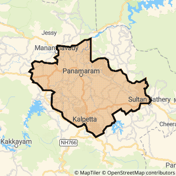
Wayanad District Map
Current Corona Virus Infected Patients Count in Wayanad District
| City Name | District Name | Total Covid cases |
|---|
Wayanad Live Weather
Temperature: 18.7 °C
overcast clouds
Humidity: 95%
Wind : 0.21 mt/sec towards SW
StationName : "Kalpatta"
observed on 1 Hours Back
Temperature: 18.7 °C
overcast clouds
Humidity: 95%
Wind : 0.21 mt/sec towards SW
StationName : "Kalpatta"
observed on 1 Hours Back
Wayanad Weather Forecast for Next 5 days
03-01-2026
17.5°C to 27.1°C
overcast clouds, light rain, broken clouds, scattered clouds
17.5°C to 27.1°C
overcast clouds, light rain, broken clouds, scattered clouds
04-01-2026
16.5°C to 28.9°C
scattered clouds, few clouds, overcast clouds, light rain
16.5°C to 28.9°C
scattered clouds, few clouds, overcast clouds, light rain
05-01-2026
15.9°C to 29.2°C
clear sky, few clouds, broken clouds
15.9°C to 29.2°C
clear sky, few clouds, broken clouds
06-01-2026
14.1°C to 28.0°C
broken clouds, scattered clouds, overcast clouds
14.1°C to 28.0°C
broken clouds, scattered clouds, overcast clouds
07-01-2026
13.0°C to 28.7°C
broken clouds, overcast clouds
13.0°C to 28.7°C
broken clouds, overcast clouds
Temples in Wayanad
Historical Daily Max Temperatures (Next 7 Days)
| Years | 01 Jan | 02 Jan | 03 Jan | 04 Jan | 05 Jan | 06 Jan | 07 Jan |
|---|---|---|---|---|---|---|---|
| 2025 | |||||||
| 2024 | |||||||
| 2023 |
About Wayanad District
Wayanad District is one among 14 Districts of Kerala State ,India. Wayanad District Administrative head quarter is Kalpetta. It is is Located 421 KM South towards State capital Thiruvananthapuram . Wayanad District population is 816558. It is Smallest district in Kerala State by population.Geography and Climate Wayanad District
It is Located at Latitude-11.6, Longitude-76.0. Wayanad District is sharing border with Mysore District to the North , Kozhikode District to the South , The Nilgiris District to the East . It is sharing Border with Karnataka State to the North , Tamil Nadu State to the East . Wayanad District occupies an area of approximately 2131 square kilometres. . Its in the 52 meters to 18 meters elevation range.This District belongs to Southern India .DemoGraphics of Wayanad District
Malayalam is the Local Language here. Also People Speaks English . Wayanad District is divided into 3 Blocks , 15 Panchayats , 429 Villages. Mananthavady Block is the Smallest Block by population with 242125 population. Sulthan Bathery Block is the Biggest Block by population with 288896 population.Census 2011 of Wayanad District
Wayanad district Total population is 816558 according to census 2011.Males are 401257 and Females are 415301 .Literate people are 540235 among total.Its total area is 2131 sq.km. It is the 14 th largest district in the state by Population . But 7 th Largest District in the state By Area. 475 th Largest District in the Country By Population. 13 th highest District in the State By literacy rate. 25 th highest District in the Country By literacy rate.its literacy Rate is 89.32Politics in Wayanad District
CPM , Indian National Congress , SJD , CPI , INC are the major political parties in Wayanad District.Assembly constituencies in Wayanad District
Total 3 Assembly constituencies in Wayanad District.| Constituency name | MLA name | Party |
|---|---|---|
| Mananthavady | O.R.Kelu | CPM |
| Sulthanbathery | I.C Balakrishnan | INC |
| Kalpetta | Adv.T Siddiqu | CPM |
Parliament constituencies in Wayanad District
Total 1 Parliament constituencies in Wayanad District.| Constituency name | MP name | Party |
|---|---|---|
| Wayanad | Rahul Gandhi | Indian National Congress |
Wayanad District Political Map
Wayanad Commerce
Total Registered Comapnies with Ministry of Corporate Affairs (MCA) in Wayanad are 342Company Name : GREESHMAM RESORTS PRIVATE LIMITED
Type Of Business : Trading
Capital : 19.0043 Crores
Company Name : SILVERCASTLE HOLIDAYS AND RESORTS (INDIA) PRIVATE LIMITED
Type Of Business : Trading
Capital : 16.55 Crores
Company Name : ASIAN SURYA UDYOG PRIVATE LIMITED
Type Of Business : Trading
Capital : 8.0 Crores
Company Name : PANDA FOODS INDIA PRIVATE LIMITED
Type Of Business : Manufacturing (Food stuffs)
Capital : 4.6125 Crores
More Wayanad Registered Companies
Wayanad District Tourism
Mananthavady , Muthanga Wildlife Sanctuary , Sulthan-Battery , Thirunelli , Tholpetty , Wayanad , Muthanga Wildlife Sanctuary , Edakkal caves , Kuruva island , Thirunelli Lord Vishnu temple , Madathillkavu Devi Temple , Puthiyakavu Devi Temple , Panchatirtha , Thirunelly Temple , Brahmasthan Temple , Banasura Dam , Karapuzha Dam , Kanthapara Falls , are the Tourist destinations to Visit.
Wayanad Transport
Road Transport
District Headquarters Kalpetta is well connected by road . Kalpetta is about 421 KM by road to Thiruvananthapuram( Capital of Kerala )Rail Transport
Bus Transport
Kerala State Road Transport Corporation ( KSRTC) runs Busses from Major cities to Towns and Villages in this District.
Pin Codes in Wayanad District
673592
( Sulthan Bathery ) ,
673575
( Pozhuthana ) ,
673581
( Vatuvanchal ) ,
673579
( Pulpalli ) ,
670731
( Vellamunda ) ,
673122
( Kalpetta North ) ,
673591
( Meenangadi ) ,
673577
( Meppadi ) ,
673123
( Chundale ) ,
670721
( Panamaram ) ,
673121
( Kalpetta ) ,
673595
( Cheeral ) ,
670645
( Mananthavady ) ,
673596
( Kenichira ) ,
673593
( Ambalavayal ) ,
673576
( Vythiri ) ,
670646
( Kartikulam ) ,
670644
( Thalappuzha ) ,
673589
( Thariote) ,
673124
( Kaniyambetta) ,
more PinCodes
Hotels in Wayanad
Tamarind KTDC Easy Hotel - Malappuram
Karimpuzha; Chungathara. P.O; Nilambur; Malappuram; Kerala; Pin code- 679334
Malappuram
Price Range : Rs. 1090 - Rs. 1500
Maharani Hotel
Taluk Road Calicut - 673004, India
Kozhikode (Calicut)
Contact No: 0495-2723101
Price Range : Rs. 1000 - Rs. 3100
Malabar Gate Hotel
Ram Mohan Road Calicut - 673004, India
Kozhikode (Calicut)
Contact No: 0495-2724534
Email: malabargate@hotmail.com
Price Range : Rs. 2200 - Rs. 4500
Chakkalackal Tourist Home
Kalluvayal Road, Sulthan Bathery, Wayanad - 673592, India
Wayanad
Contact No: 04936 - 221740
Price Range : Rs. 400 - Rs. 1200
BusStops in Wayanad Lakes in Wayanad Temples in Wayanad Shops in Wayanad Wayanad Hospitals Hotel/Restaurants in Wayanad Wayanad RailwayStations Wayanad BusStops ATM in Wayanad
Near Cities
Kalpetta 1 KM near
Mavoor 46 KM near
Gudalur 48 KM near
Quilandy 51 KM near
Near By Air Ports
Calicut Airport 60 KM near
Mysore Airport 110 KM near
Peelamedu Airport 137 KM near
Kochi Airport 185 KM near
Near By Districts
Wayanad 0 KM near
Kozhikode 54 KM near
Malappuram 69 KM near
The Nilgiris 79 KM near