| Home | City Bus | Maps | Villages | Cities | Rail | Tourist Places | School | College | Pin Codes | Corona Cases Count |
| Distance Calculator Bus Services IFSC Codes Trace Mobile Number Weather Search Place Trace IP Available Cash ATM/Banks Locate Polling Booth Report an Error contact People |
Solan District.
Currently In:
India >>
Himachal Pradesh
Head Quarters : Solan
Language : Hindi
Area: 1936 sq. km
Population : 576670
Sex Ratio : 884
Density : 298/ sq. km
Literacy : 85.02
Elevation / Altitude: 814 - 1483 meters. Above Seal level
Current Time 11:03 PM
Date: Friday , Jan 02,2026 (IST)
Time zone: IST (UTC+5:30)
District Pin code Index: 171XXX,173XXX,174XXX
Vehicle Registration Number: HP-12,HP-13,HP-14,HP-15,HP-64
RTO Office: Kandaghat,Nalagarh,Parwanoo,Solan
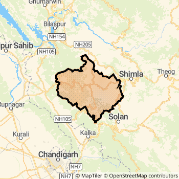
Solan District Map
Current Corona Virus Infected Patients Count in Solan District
| City Name | District Name | Total Covid cases |
|---|
Solan Live Weather
Temperature: 4.7 °C
clear sky
Humidity: 68%
Wind : 2.13 mt/sec towards E
StationName : "Solan"
observed on 42 Mins Back
Temperature: 4.7 °C
clear sky
Humidity: 68%
Wind : 2.13 mt/sec towards E
StationName : "Solan"
observed on 42 Mins Back
Solan Weather Forecast for Next 5 days
03-01-2026
4.4°C to 4.7°C
clear sky
4.4°C to 4.7°C
clear sky
04-01-2026
3.9°C to 12.5°C
scattered clouds, broken clouds, overcast clouds, few clouds, clear sky
3.9°C to 12.5°C
scattered clouds, broken clouds, overcast clouds, few clouds, clear sky
05-01-2026
3.6°C to 12.7°C
clear sky
3.6°C to 12.7°C
clear sky
06-01-2026
3.5°C to 14.5°C
clear sky
3.5°C to 14.5°C
clear sky
07-01-2026
4.0°C to 14.4°C
clear sky, few clouds
4.0°C to 14.4°C
clear sky, few clouds
Temples in Solan
Historical Daily Max Temperatures (Next 7 Days)
| Years | 02 Jan | 03 Jan | 04 Jan | 05 Jan | 06 Jan | 07 Jan | 08 Jan |
|---|---|---|---|---|---|---|---|
| 2025 | |||||||
| 2024 | |||||||
| 2023 |
About Solan District
Solan District is one among 12 Districts of Himachal Pradesh State ,India. Solan District Administrative head quarter is Solan. It is is Located 26 KM North towards State capital Shimla . Solan District population is 576670. It is 4 th Largest District in the State by population.Geography and Climate Solan District
It is Located at Latitude-30.9, Longitude-77.1. Solan District is sharing border with Panchkula District to the west , Sirmaur District to the South , Rupnagar District to the west . It is sharing Border with Haryana State to the South , Punjab State to the west . Solan District occupies an area of approximately 1936 square kilometres. . Its in the 814 meters to 1483 meters elevation range.This District belongs to Hindi Belt India .DemoGraphics of Solan District
Hindi is the Local Language here. Solan District is divided into 5 Tehsils , 133 Panchayats , 2445 Villages. Kandaghat Tehsil is the Smallest Tehsil by population with 35136 population. Nalagarh Tehsil is the Biggest Tehsil by population with 155619 population.Census 2011 of Solan District
Solan district Total population is 576670 according to census 2011.Males are 306088 and Females are 270582 .Literate people are 381525 among total.Its total area is 1936 sq.km. It is the 4 th largest district in the state by Population . But 9 th Largest District in the state By Area. 524 th Largest District in the Country By Population. 4 th highest District in the State By literacy rate. 79 th highest District in the Country By literacy rate.its literacy Rate is 85.02Politics in Solan District
BJP , INC are the major political parties in Solan District.Assembly constituencies in Solan District
Total 8 Assembly constituencies in Solan District.| Constituency name | MLA name | Party |
|---|---|---|
| Arki | Sanjay | BJP |
| Nalagarh | K. L. Thakur | BJP |
| Doon | Ram Kumar | INC |
| Solan | Dhani Ram Shandil | INC |
| Kasauli | Vinod Sultanpuri | BJP |
| Pachhad | Reena | BJP |
Parliament constituencies in Solan District
Total 1 Parliament constituencies in Solan District.| Constituency name | MP name | Party |
|---|---|---|
| Shimla | SURESH KUMAR KASHYAP | Bharatiya Janata Party |
Solan District Political Map
Solan Commerce
Total Registered Comapnies with Ministry of Corporate Affairs (MCA) in Solan are 826Company Name : JAYPEE KARCHAM HYDRO CORPORATION LIMITED
Type Of Business : Electricity, Gas & Water companies
Capital : 2010.0 Crores
Company Name : BINA POWER SUPPLY COMPANY LIMITED
Type Of Business : Others
Capital : 826.0 Crores
Company Name : JAIPRAKASH POWER VENTURES LIMITED
Type Of Business : Manufacturing (Others)
Capital : 534.893 Crores
Company Name : MOREPEN LABORATORIES LIMITED
Type Of Business : Manufacturing (Metals & Chemicals, and products thereof)
Capital : 187.317 Crores
More Solan Registered Companies
Solan District Tourism
This district is in High Altitude .Kasauli , Parwanoo , Solan , Christ Church , Gurudwara Shri Guru Nanak Ji , Monkey Point Renuka Temple , Gurkha Fort , Dagshai , Shoolini Mata temple , Jatoli Shiv temple , Yungdrung Tibetan Monastery , are the Tourist destinations to Visit.
Solan Transport
Road Transport
District Headquarters Solan is well connected by road . Baddi , Solan are the Cities in this district having road connectivity to major towns and remote villages. Solan is about 26 KM by road to Shimla( Capital of Himachal Pradesh )Rail Transport
Some of the rail way stations in district are Shimla , Barog , Jutogh , Taradevi , Summer Hill , Shoghi , Dharampur Himachal , Salogra .... which connects most of the towns and villages in the District.Bus Transport
Himachal Pradesh State Road Transportation ( HRTC) runs Busses from Major cities to Towns and Villages in this District.
Pin Codes in Solan District
173209
( Dharampur (Solan)) ,
173206
( Subathu ) ,
173229
( Kumarhatti ) ,
173211
( Saproon ) ,
173210
( Dagshai ) ,
174102
( Ramshahar ) ,
173207
( Kunihar ) ,
173201
( Garkhal ) ,
173213
( Chambaghat ) ,
173221
( Domehar ) ,
173215
( Kandaghat ) ,
174101
( Nalagarh ) ,
173230
( Nauni ) ,
174103
( Barotiwala ) ,
173205
( Baddi ) ,
173225
( Jubbar ) ,
173214
( Solan Brewery ) ,
173223
( Oachghat ) ,
173208
( Arki ) ,
173204
( Kasauli ) ,
more PinCodes
Hotels in Solan
Palace Retreat
Hotel Palace Retreat, Sub Divsion - Arki, District - Solan, Himachal Pradesh, INDIA .
Arki
Price Range : Rs. 1600 - Rs. 2000
Gables, Hotel
Mashobra, Shimla, Himachal Pradesh 171007
Mashobra
Contact No: (177) - 2740167 , 2740171 , 2740173
Price Range : Rs. 7000 - Rs. 7000
Sukh Sagar Hotel
Circular Road, Across Victory Tunnel Near Tara Convent School, Shimla-171003
Shimla
Contact No: 0177-2803973 ,2803974, 098162-03322 - 098160-03322
Website: http://www.hotelsukhsagar.com/aboutus.aspx
Email: contact@hotelsukhsagar.com , hotelsukhsagar@gmail.com
Price Range : Rs. 1400 - Rs. 1600
Rock Heaven Hotel
mashobra, shimla-171007
Mashobra
Contact No: 0177-2740141, 9816056448
Price Range : Rs. 1000 - Rs. 1300
BusStops in Solan Lakes in Solan Temples in Solan Shops in Solan Solan Hospitals Hotel/Restaurants in Solan Solan RailwayStations Solan BusStops ATM in Solan
Near Cities
Solan 3 KM near
Kalka 20 KM near
Shimla 24 KM near
Pinjore 25 KM near
Near By Air Ports
Simla Airport 26 KM near
Chandigarh Airport 44 KM near
Dehra Dun Airport 123 KM near
Bhuntar Airport 133 KM near
Near By Districts
Solan 0 KM near
Shimla 24 KM near
Panchkula 38 KM near
Chandigarh 41 KM near