| Home | City Bus | Maps | Villages | Cities | Rail | Tourist Places | School | College | Pin Codes | Corona Cases Count |
| Distance Calculator Bus Services IFSC Codes Trace Mobile Number Weather Search Place Trace IP Available Cash ATM/Banks Locate Polling Booth Report an Error contact People |
Division : Tirhut
Head Quarters : Muzaffarpur
Language : Maithili and Hindi, Urdu, Vajjika And Bhojpuri
Area: 3173 sq. km
Population : 4778610
Sex Ratio : 898
Density : 1506/ sq. km
Literacy : 65.68
Elevation / Altitude: 66 - 52 meters. Above Seal level
Current Time 08:05 PM
Date: Friday , Jan 02,2026 (IST)
Time zone: IST (UTC+5:30)
District Pin code Index: 842XXX,843XXX,844XXX,847XXX
Vehicle Registration Number: BR-06
RTO Office: Muzaffarpur
Tourist Places near Muzaffarpur
Muzaffarpur (Muzaffarpur Town) Vaishali Samastipur Darbhanga Sitamarhi Kesariya
Muzaffarpur (Muzaffarpur Town) Vaishali Samastipur Darbhanga Sitamarhi Kesariya
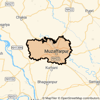
Muzaffarpur District Map
Current Corona Virus Infected Patients Count in Muzaffarpur District
| City Name | District Name | Total Covid cases |
|---|
Muzaffarpur Live Weather
Temperature: 16.6 °C
clear sky
Humidity: 48%
Wind : 2 mt/sec towards NW
StationName : "Muzaffarpur"
observed on 1 Hours Back
Temperature: 16.6 °C
clear sky
Humidity: 48%
Wind : 2 mt/sec towards NW
StationName : "Muzaffarpur"
observed on 1 Hours Back
Muzaffarpur Weather Forecast for Next 5 days
03-01-2026
12.9°C to 17.1°C
clear sky
12.9°C to 17.1°C
clear sky
04-01-2026
11.7°C to 23.9°C
clear sky
11.7°C to 23.9°C
clear sky
05-01-2026
12.0°C to 23.4°C
clear sky
12.0°C to 23.4°C
clear sky
06-01-2026
11.6°C to 23.4°C
clear sky
11.6°C to 23.4°C
clear sky
07-01-2026
10.9°C to 23.3°C
clear sky
10.9°C to 23.3°C
clear sky
Temples in Muzaffarpur
Baba Garibnath Dham,
Baba Garibnath Dham,
Historical Daily Max Temperatures (Next 7 Days)
| Years | 02 Jan | 03 Jan | 04 Jan | 05 Jan | 06 Jan | 07 Jan | 08 Jan |
|---|---|---|---|---|---|---|---|
| 2025 | |||||||
| 2024 | |||||||
| 2023 |
About Muzaffarpur District
Muzaffarpur District is one among 38 Districts of Bihar State ,India. Muzaffarpur District Administrative head quarter is Muzaffarpur. It is is Located 72 KM South towards State capital Patna . Muzaffarpur District population is 4778610. It is 3 rd Largest District in the State by population.Geography and Climate Muzaffarpur District
It is Located at Latitude-26.1, Longitude-85.3. Muzaffarpur District is sharing border with Darbhanga District to the East , Purbi Champaran District to the North , Samastipur District to the East , Sitamarhi District to the North , Vaishali District to the South . Muzaffarpur District occupies an area of approximately 3173 square kilometres. . Its in the 66 meters to 52 meters elevation range.This District belongs to Hindi Belt India .DemoGraphics of Muzaffarpur District
Maithili is the Local Language here. Also People Speaks Hindi, Urdu, Vajjika And Bhojpuri . Muzaffarpur District is divided into 17 Blocks , 396 Panchayats , 1753 Villages. Muraul Block is the Smallest Block by population with 74670 population. Mushahari Block is the Biggest Block by population with 555902 population.Major producing Items,Crops,Industries and Exports from Muzaffarpur District
Bamboo&Amp;SoilItem, BambooItem, Bangles, Basket, Bidi, Biscuits, Bricks, Chemical, ChemicalFert, ClayPot, Cloth, Crockery, Cuminseeds, Earthenware, Furture, Gur, HandFan, IronGoods, IronImpliments, I are the major producing Items and Exports from here.Census 2011 of Muzaffarpur District
Muzaffarpur district Total population is 4778610 according to census 2011.Males are 2517708 and Females are 2260902 .Literate people are 3161528 among total.Its total area is 3173 sq.km. It is the 3 rd largest district in the state by Population . But 11 th Largest District in the state By Area. 24 th Largest District in the Country By Population. 18 th highest District in the State By literacy rate. 476 th highest District in the Country By literacy rate.its literacy Rate is 65.68Politics in Muzaffarpur District
JD(U) , Bharatiya Janata Party , BJP , Lok Jan Shakti Party , RJD are the major political parties in Muzaffarpur District.Assembly constituencies in Muzaffarpur District
Total 11 Assembly constituencies in Muzaffarpur District.| Constituency name | MLA name | Party |
|---|---|---|
| Gaighat | Niranjan Roy | BJP |
| Aurai | Ram Surat Kumar | BJP |
| Minapur | Rajeev Kumar | JD(U) |
| Bochaha | Musafir Paswan | JD(U) |
| Sakra | Ashok Kumar Chodhary | JD(U) |
| Kurhani | Anil Kumar Sahni | JD(U) |
Parliament constituencies in Muzaffarpur District
Total 2 Parliament constituencies in Muzaffarpur District.| Constituency name | MP name | Party |
|---|---|---|
| Muzaffarpur | Ajay Nishad | Bharatiya Janata Party |
| Vaishali | Veena Devi (W/o Dinesh Prasad Singh) | Lok Jan Shakti Party |
Muzaffarpur District Political Map
Muzaffarpur Commerce
Total Registered Comapnies with Ministry of Corporate Affairs (MCA) in Muzaffarpur are 1164Company Name : SUVIKSHA HEALTH CARE PRIVATE LIMITED
Type Of Business : Community, personal & Social Services
Capital : 8.0 Crores
Company Name : LAVANYA FINVEST PRIVATE LIMITED
Type Of Business : Finance
Capital : 6.85961 Crores
Company Name : VATSA AUTOMOBILES PRIVATE LIMITED
Type Of Business : Trading
Capital : 6.6448 Crores
Company Name : LAVANYA PUREFOOD PRIVATE LIMITED
Type Of Business : Manufacturing (Food stuffs)
Capital : 5.5 Crores
More Muzaffarpur Registered Companies
Muzaffarpur District Tourism
Muzaffarpur , Baba Garibnath Temple , Chaturbhuj Sthan Temple , Shri Ram Temple , Kali Mata Temple , Simri Mai Temple , Ram Chandra Shahi Museum , Ramna s Tripur Sundari Temple , are the Tourist destinations to Visit.
Temples in Muzaffarpur District
Baba Garibnath Dham, are the famous temple in Muzaffarpur DistrictMuzaffarpur Transport
Road Transport
District Headquarters Muzaffarpur is well connected by road . Muzaffarpur , Kanti , Motipur are the Cities in this district having road connectivity to major towns and remote villages. Muzaffarpur is about 72 KM by road to Patna( Capital of Bihar )Rail Transport
Some of the rail way stations in district are Muzaffarpur Junction , Motipur , Dholi , Kanti , Silout , Narayanpur Anant , Dubaha , Siho .... which connects most of the towns and villages in the District.Bus Transport
Bihar State Road Transportation Corporation ( BSTDC) runs Busses from Major cities to Towns and Villages in this District.
Pin Codes in Muzaffarpur District
843102
( Bariarpur (Muzaffarpur)) ,
843139
( Jagdishpur Baghnagari ) ,
843115
( Piar ) ,
843109
( Kanti ) ,
843106
( Gidha ) ,
843133
( Bharwari (Muzaffarpur)) ,
843162
( S.Sandha ) ,
843312
( Aurai (Muzaffarpur)) ,
843121
( D.A.College ) ,
844112
( Baghi (Muzaffarpur)) ,
843143
( Karja ) ,
842005
( M.I.C. ) ,
843129
( Narma ) ,
844127
( Turki ) ,
843117
( Rampur Hari ) ,
843144
( Katesar ) ,
843321
( Katra (Muzaffarpur)) ,
847107
( Keotsa Baruari ) ,
843125
( Kurnowl ) ,
843128
( Minapur ) ,
more PinCodes
Hotels in Muzaffarpur
Lichchavi Vihar Hotel
Eliy chety Road, Near Govt Bus stand Muzaffarpur - 842001, India
Muzaffarpur
Contact No: 0621 - 2228512
Price Range : Rs. 400 - Rs. 800
Meenakshi International Hotel
Opp. Railway Station; Muzaffarpur; Bihar
Muzaffarpur
Price Range : Rs. 1650 - Rs. 3900
BusStops in Muzaffarpur Lakes in Muzaffarpur Temples in Muzaffarpur Shops in Muzaffarpur Muzaffarpur Hospitals Hotel/Restaurants in Muzaffarpur Muzaffarpur RailwayStations Muzaffarpur BusStops ATM in Muzaffarpur
Near Cities
Muzaffarpur 1 KM near
Kanti 13 KM near
Motipur 28 KM near
Lalganj 38 KM near
Near By Air Ports
Patna Airport 72 KM near
Gaya Airport 177 KM near
Gorakhpur Airport 229 KM near
Varanasi Airport 295 KM near
Near By Districts
Muzaffarpur 0 KM near
Sheohar 49 KM near
Samastipur 54 KM near
Vaishali 57 KM near