| Home | City Bus | Maps | Villages | Cities | Rail | Tourist Places | School | College | Pin Codes | Corona Cases Count |
| Distance Calculator Bus Services IFSC Codes Trace Mobile Number Weather Search Place Trace IP Available Cash ATM/Banks Locate Polling Booth Report an Error contact People |
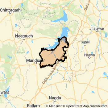
Mandsaur District.
Currently In:
India >>
Madhya Pradesh
Division : Ujjain
Head Quarters : Mandsaur
Language : Hindi and Malvi
Area: 9791 sq. km
Population : 1339832
Sex Ratio : 966
Density : 242/ sq. km
Literacy : 72.75
Elevation / Altitude: 469 - 384 meters. Above Seal level
Current Time 07:15 PM
Date: Wednesday , Jan 07,2026 (IST)
Time zone: IST (UTC+5:30)
District Pin code Index: 458XXX
Vehicle Registration Number: MP-14
RTO Office: Mandsaur
Tourist Places near Mandsaur
Neemuch (Nimach) Ratlam (Ratnapuri) Banswara Jhalawar Ujjain (Avanti) Bijolia (Beejoliya Kalan)
Neemuch (Nimach) Ratlam (Ratnapuri) Banswara Jhalawar Ujjain (Avanti) Bijolia (Beejoliya Kalan)
Mandsaur District Map
Current Corona Virus Infected Patients Count in Mandsaur District
| City Name | District Name | Total Covid cases |
|---|
Mandsaur Live Weather
Temperature: 19.2 °C
clear sky
Humidity: 40%
Wind : 4.54 mt/sec towards NE
StationName : "Mandsaur"
observed on 1 Hours Back
Temperature: 19.2 °C
clear sky
Humidity: 40%
Wind : 4.54 mt/sec towards NE
StationName : "Mandsaur"
observed on 1 Hours Back
Mandsaur Weather Forecast for Next 5 days
08-01-2026
12.1°C to 19.3°C
clear sky
12.1°C to 19.3°C
clear sky
09-01-2026
11.1°C to 24.2°C
clear sky, few clouds, broken clouds
11.1°C to 24.2°C
clear sky, few clouds, broken clouds
10-01-2026
12.7°C to 26.4°C
scattered clouds, broken clouds, clear sky
12.7°C to 26.4°C
scattered clouds, broken clouds, clear sky
11-01-2026
13.9°C to 26.5°C
scattered clouds, broken clouds, few clouds, clear sky
13.9°C to 26.5°C
scattered clouds, broken clouds, few clouds, clear sky
12-01-2026
13.0°C to 24.0°C
few clouds, clear sky, scattered clouds, overcast clouds, broken clouds
13.0°C to 24.0°C
few clouds, clear sky, scattered clouds, overcast clouds, broken clouds
Temples in Mandsaur
Historical Daily Min/Max Temperatures (Next 7 Days)
| Years | 07 Jan | 08 Jan | 09 Jan | 10 Jan | 11 Jan | 12 Jan | 13 Jan |
|---|---|---|---|---|---|---|---|
| 2025 | 26.0°C/ 14.0°C | 25.0°C/ 13.0°C | 24.0°C/ 9.0°C | 20.0°C/ 10.0°C | |||
| 2024 | 24.0°C/ 13.0°C | 26.0°C/ 14.0°C | 27.0°C/ 16.0°C | 27.0°C/ 13.0°C | |||
| 2023 | 26.0°C/ 16.0°C | 25.0°C/ 13.0°C | 23.0°C/ 10.0°C |
About Mandsaur District
Mandsaur District is one among 50 Districts of Madhya Pradesh State ,India. Mandsaur District Administrative head quarter is Mandsaur. It is is Located 300 KM East towards State capital Bhopal . Mandsaur District population is 1339832. It is 26 th Largest District in the State by population.Geography and Climate Mandsaur District
It is Located at Latitude-24.0, Longitude-75.0. Mandsaur District is sharing border with Neemuch District to the North , Kota District to the North , Pratapgarh District to the west . It is sharing Border with Rajasthan State to the North . Mandsaur District occupies an area of approximately 9791 square kilometres. . Its in the 469 meters to 384 meters elevation range.This District belongs to Hindi Belt India .DemoGraphics of Mandsaur District
Hindi is the Local Language here. Also People Speaks Malvi . Mandsaur District is divided into 5 Tehsils , 448 Panchayats , 921 Villages. Bhanpura Tehsil is the Smallest Tehsil by population with 132722 population. Mandsaur Tehsil is the Biggest Tehsil by population with 396919 population.Census 2011 of Mandsaur District
Mandsaur district Total population is 1339832 according to census 2011.Males are 681502 and Females are 658330 .Literate people are 886433 among total.Its total area is 9791 sq.km. It is the 26 th largest district in the state by Population . But 7 th Largest District in the state By Area. 359 th Largest District in the Country By Population. 18 th highest District in the State By literacy rate. 326 th highest District in the Country By literacy rate.its literacy Rate is 72.75Politics in Mandsaur District
Bharatiya Janata Party , BJP , INC are the major political parties in Mandsaur District.Assembly constituencies in Mandsaur District
Total 4 Assembly constituencies in Mandsaur District.| Constituency name | MLA name | Party |
|---|---|---|
| Mandsour | Vipin Jain | BJP |
| Malhargarh | Jagdish Devda | BJP |
| Suwasra | Dung Hardeepsingh | INC |
| Garoth | Chandar Singh Sisodiya | BJP |
Parliament constituencies in Mandsaur District
Total 1 Parliament constituencies in Mandsaur District.| Constituency name | MP name | Party |
|---|---|---|
| Mandsaur | Sudheer Gupta | Bharatiya Janata Party |
Mandsaur District Political Map
Mandsaur Commerce
Total Registered Comapnies with Ministry of Corporate Affairs (MCA) in Mandsaur are 155Company Name : MID INDIA INDUSTRIES LIMITED
Type Of Business : Manufacturing (Textiles)
Capital : 16.3 Crores
Company Name : PREM TEXTILES (INTERNATIONAL) PRIVATE LIMITED
Type Of Business : Manufacturing (Textiles)
Capital : 10.2641 Crores
Company Name : NARAYAN NIRYAT INDIA PRIVATE LIMITED
Type Of Business : Manufacturing (Food stuffs)
Capital : 4.25 Crores
Company Name : M P PROTEINS PRIVATE LIMITED
Type Of Business : Manufacturing (Food stuffs)
Capital : 2.22458 Crores
More Mandsaur Registered Companies
Mandsaur District Tourism
Mandsaur Transport
Road Transport
District Headquarters Mandsaur is well connected by road . Mandsaur , Shamgarh are the Cities in this district having road connectivity to major towns and remote villages. Mandsaur is about 300 KM by road to Bhopal( Capital of Madhya Pradesh )Rail Transport
Some of the rail way stations in district are Shamgarh , Bhawani Mandi , Mandsor , Piplia , Garoth , Dalauda , Malhargarh , Kurlasi .... which connects most of the towns and villages in the District.Bus Transport
Pin Codes in Mandsaur District
458553
( Narayangarh (Mandsaur)) ,
458990
( Sitamau ) ,
458775
( Bhanpura ) ,
458556
( Budha ) ,
458558
( Nahargarh ) ,
458664
( Piplia ) ,
458888
( Suwasara Mandi ) ,
458667
( Dalauda ) ,
458880
( Garoth ) ,
458895
( Degaon Mali ) ,
458339
( Malhargarh ) ,
458001
( Mandsaur ) ,
458002
( Sarafa Mandsaur ) ,
458883
( Shamgarh ) ,
458389
( Laduna ) ,
458771
( Gandhi Sagar ) ,
458778
( Bhensoda Mandi ) ,
458669
( Kachnara Flag ) ,
458660
( Kayampur) ,
more PinCodes
Hotels in Mandsaur
Bharhut Hotel
Police Line Chowk;; Satna;; Madhya Pradesh; Pin code- 458001
Satna
Price Range : Rs. 1600 - Rs. 2400
BusStops in Mandsaur Lakes in Mandsaur Temples in Mandsaur Shops in Mandsaur Mandsaur Hospitals Hotel/Restaurants in Mandsaur Mandsaur RailwayStations Mandsaur BusStops ATM in Mandsaur
Near Cities
Mandsaur 3 KM near
Pratapgarh 31 KM near
Manasa 51 KM near
Neemuch 53 KM near
Near By Air Ports
Dabok Airport 148 KM near
Indore Airport 188 KM near
Bhopal Airport 279 KM near
Vadodara Airport 301 KM near
Near By Districts
Mandsaur 0 KM near
Pratapgarh 30 KM near
Neemuch 52 KM near
Banswara 93 KM near