| Home | City Bus | Maps | Villages | Cities | Rail | Tourist Places | School | College | Pin Codes | Corona Cases Count |
| Distance Calculator Bus Services IFSC Codes Trace Mobile Number Weather Search Place Trace IP Available Cash ATM/Banks Locate Polling Booth Report an Error contact People |
Harda District.
Currently In:
India >>
Madhya Pradesh
Division : Narmadapuram
Head Quarters : Harda
Language : Hindi and Bhuani
Area: 2644 sq. km
Population : 570302
Sex Ratio : 932
Density : 171/ sq. km
Literacy : 74.04
Elevation / Altitude: 309 - 281 meters. Above Seal level
Current Time 09:56 PM
Date: Friday , Jan 02,2026 (IST)
Time zone: IST (UTC+5:30)
District Pin code Index: 461XXX
Vehicle Registration Number: MP-47
RTO Office: Harda
Tourist Places near Harda
Itarsi Bhimbetka (Bhim Baithaka) Omkareshwar (Omkareshwar Jyothirlinga) Melghat Tiger Reserve Bhopal Chikhaldara Wildlife Sanctuary
Itarsi Bhimbetka (Bhim Baithaka) Omkareshwar (Omkareshwar Jyothirlinga) Melghat Tiger Reserve Bhopal Chikhaldara Wildlife Sanctuary
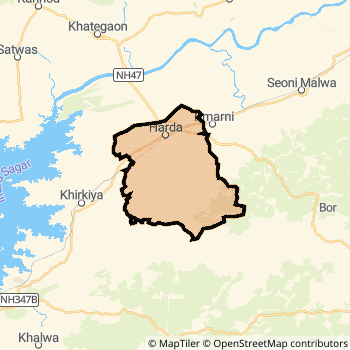
Harda District Map
Current Corona Virus Infected Patients Count in Harda District
| City Name | District Name | Total Covid cases |
|---|
Harda Live Weather
Temperature: 21.2 °C
few clouds
Humidity: 47%
Wind : 2.24 mt/sec towards S
StationName : "Harda"
observed on Now
Temperature: 21.2 °C
few clouds
Humidity: 47%
Wind : 2.24 mt/sec towards S
StationName : "Harda"
observed on Now
Harda Weather Forecast for Next 5 days
03-01-2026
16.7°C to 20.9°C
scattered clouds, few clouds
16.7°C to 20.9°C
scattered clouds, few clouds
04-01-2026
14.8°C to 27.3°C
clear sky
14.8°C to 27.3°C
clear sky
05-01-2026
14.7°C to 27.2°C
clear sky
14.7°C to 27.2°C
clear sky
06-01-2026
13.2°C to 26.0°C
clear sky
13.2°C to 26.0°C
clear sky
07-01-2026
12.7°C to 28.3°C
clear sky
12.7°C to 28.3°C
clear sky
Temples in Harda
Historical Daily Max Temperatures (Next 7 Days)
| Years | 02 Jan | 03 Jan | 04 Jan | 05 Jan | 06 Jan | 07 Jan | 08 Jan |
|---|---|---|---|---|---|---|---|
| 2025 | |||||||
| 2024 | |||||||
| 2023 |
About Harda District
Harda District is one among 50 Districts of Madhya Pradesh State ,India. Harda District Administrative head quarter is Harda. It is is Located 125 KM North towards State capital Bhopal . Harda District population is 570302. It is Smallest district in Madhya Pradesh State by population.Geography and Climate Harda District
It is Located at Latitude-22.3, Longitude-77.0. Harda District is sharing border with Betul District to the East , Dewas District to the west , East Nimar District to the west . Harda District occupies an area of approximately 2644 square kilometres. . Its in the 309 meters to 281 meters elevation range.This District belongs to Hindi Belt India .DemoGraphics of Harda District
Hindi is the Local Language here. Also People Speaks Bhuani . Harda District is divided into 3 Tehsils , 218 Panchayats , 512 Villages. Khirkiya Tehsil is the Smallest Tehsil by population with 138538 population. Harda Tehsil is the Biggest Tehsil by population with 190398 population.Census 2011 of Harda District
Harda district Total population is 570302 according to census 2011.Males are 295187 and Females are 275115 .Literate people are 377312 among total.Its total area is 2644 sq.km. It is the 49 th largest district in the state by Population . But 46 th Largest District in the state By Area. 526 th Largest District in the Country By Population. 11 th highest District in the State By literacy rate. 282 nd highest District in the Country By literacy rate.its literacy Rate is 74.04Politics in Harda District
Bharatiya Janata Party , BJP , INC are the major political parties in Harda District.Assembly constituencies in Harda District
Total 2 Assembly constituencies in Harda District.| Constituency name | MLA name | Party |
|---|---|---|
| Timarni | Abhijeet Shah (ANKIT BABA) | BJP |
| Harda | Dr. Ramkishore Dogne | BJP |
Parliament constituencies in Harda District
Total 1 Parliament constituencies in Harda District.| Constituency name | MP name | Party |
|---|---|---|
| Betul | DURGA DAS (D.D.) UIKEY | Bharatiya Janata Party |
Harda District Political Map
Harda Commerce
Total Registered Comapnies with Ministry of Corporate Affairs (MCA) in Harda are 36Company Name : SOUBHAGYALAXMI FOODS PRIVATE LIMITED
Type Of Business : Trading
Capital : 90.856 Lakhs
Company Name : SHIVAM PLYWOOD PVT LTD
Type Of Business : Manufacturing (Wood Products)
Capital : 29.1 Lakhs
Company Name : HARYALI AGROSEEDS AND FERTILIZERS PRIVATE LIMITED
Type Of Business : Agriculture and Allied Activities
Capital : 27.0 Lakhs
Company Name : HOTEL RAJ-RESIDENCY (HARDA) PRIVATE LIMITED
Type Of Business : Trading
Capital : 24.06 Lakhs
More Harda Registered Companies
Harda District Tourism
Harda Transport
Road Transport
District Headquarters Harda is well connected by road . Harda is about 125 KM by road to Bhopal( Capital of Madhya Pradesh )Rail Transport
Some of the rail way stations in district are Harda , Khirkiya , Timarni , Bhiringi , Masangaon , Charkhera , Palasner , Kurawan .... which connects most of the towns and villages in the District.Bus Transport
Pin Codes in Harda District
461228
( Timarni ) ,
461441
( Khirkiyan R.S. ) ,
461331
( Ptc Harda ) ,
461335
( Sirali) ,
461444
( Charuwa) ,
461251
( Rahatgaon) ,
more PinCodes
Hotels in Harda
BusStops in Harda Lakes in Harda Temples in Harda Shops in Harda Harda Hospitals Hotel/Restaurants in Harda Harda RailwayStations Harda BusStops ATM in Harda
Near Cities
Harda 4 KM near
Seoni-Malwa 45 KM near
Itarsi 83 KM near
Mandideep 106 KM near
Near By Air Ports
Bhopal Airport 121 KM near
Indore Airport 155 KM near
Sonegaon Airport 275 KM near
Jabalpur Airport 328 KM near
Near By Districts
Harda 0 KM near
Hoshangabad 88 KM near
Sehore 104 KM near
Betul 107 KM near