| Home | City Bus | Maps | Villages | Cities | Rail | Tourist Places | School | College | Pin Codes | Corona Cases Count |
| Distance Calculator Bus Services IFSC Codes Trace Mobile Number Weather Search Place Trace IP Available Cash ATM/Banks Locate Polling Booth Report an Error contact People |
Division : Udaipur
Head Quarters : Dungarpur
Language : Hindi and Rajasthani
Area: 3770 sq. km
Population : 1388906
Sex Ratio : 990
Density : 368/ sq. km
Literacy : 60.78
Elevation / Altitude: 328 - 273 meters. Above Seal level
Current Time 07:13 AM
Date: Monday , Jan 05,2026 (IST)
Time zone: IST (UTC+5:30)
District Pin code Index: 314XXX
Vehicle Registration Number: RJ-12
RTO Office: Dungarpur
Tourist Places near Dungarpur
Dungarpur Banswara Udaipur (City of Lakes) Sabarkantha Ambaji Danta Ambaji
Dungarpur Banswara Udaipur (City of Lakes) Sabarkantha Ambaji Danta Ambaji
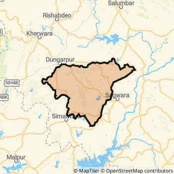
Dungarpur District Map
Current Corona Virus Infected Patients Count in Dungarpur District
| City Name | District Name | Total Covid cases |
|---|
Dungarpur Live Weather
Temperature: 10.7 °C
clear sky
Humidity: 39%
Wind : 4.81 mt/sec towards NE
StationName : "DÅ«ngarpur"
observed on Now
Temperature: 10.7 °C
clear sky
Humidity: 39%
Wind : 4.81 mt/sec towards NE
StationName : "DÅ«ngarpur"
observed on Now
Dungarpur Weather Forecast for Next 5 days
06-01-2026
12.5°C to 24.4°C
clear sky
12.5°C to 24.4°C
clear sky
07-01-2026
12.4°C to 25.0°C
clear sky
12.4°C to 25.0°C
clear sky
08-01-2026
13.0°C to 25.5°C
clear sky, broken clouds
13.0°C to 25.5°C
clear sky, broken clouds
09-01-2026
13.7°C to 25.9°C
overcast clouds, scattered clouds, few clouds, clear sky
13.7°C to 25.9°C
overcast clouds, scattered clouds, few clouds, clear sky
10-01-2026
15.2°C to 26.9°C
scattered clouds, broken clouds, few clouds
15.2°C to 26.9°C
scattered clouds, broken clouds, few clouds
Temples in Dungarpur
Historical Daily Min/Max Temperatures (Next 7 Days)
| Years | 04 Jan | 05 Jan | 06 Jan | 07 Jan | 08 Jan | 09 Jan | 10 Jan |
|---|---|---|---|---|---|---|---|
| 2025 | 27.0°C/ 21.0°C | ||||||
| 2024 | 26.0°C/ 14.0°C | ||||||
| 2023 | 25.0°C/ 17.0°C |
About Dungarpur District
Dungarpur District is one among 33 Districts of Rajasthan State ,India. Dungarpur District Administrative head quarter is Dungarpur. It is is Located 469 KM North towards State capital Jaipur . Dungarpur District population is 1388906. It is 25 th Largest District in the State by population.Geography and Climate Dungarpur District
It is Located at Latitude-23.8, Longitude-73.7. Dungarpur District is sharing border with Banswara District to the East , Udaipur District to the North , Sabar Kantha District to the west . It is sharing Border with Gujarat State to the west . Dungarpur District occupies an area of approximately 3770 square kilometres. . Its in the 328 meters to 273 meters elevation range.This District belongs to Hindi Belt India .DemoGraphics of Dungarpur District
Hindi is the Local Language here. Also People Speaks Rajasthani . Dungarpur District is divided into 5 Tehsils , Panchayats , 518 Villages.Census 2011 of Dungarpur District
Dungarpur district Total population is 1388906 according to census 2011.Males are 697943 and Females are 690963 .Literate people are 918900 among total.Its total area is 3770 sq.km. It is the 25 th largest district in the state by Population . But 31 st Largest District in the state By Area. 349 th Largest District in the Country By Population. 27 th highest District in the State By literacy rate. 553 rd highest District in the Country By literacy rate.its literacy Rate is 60.78Politics in Dungarpur District
Bharatiya Janata Party , Bhartiya Tribal Party , BJP , INC are the major political parties in Dungarpur District.Assembly constituencies in Dungarpur District
Total 4 Assembly constituencies in Dungarpur District.| Constituency name | MLA name | Party |
|---|---|---|
| Dungarpur | Ganesh Ghogra | INC |
| Aspur | Umesh Meena | BJP |
| Sagwara | Shankarlal Decha | Bhartiya Tribal Party |
| Chorasi | Rajkumar Roat | Bhartiya Tribal Party |
Parliament constituencies in Dungarpur District
Total 2 Parliament constituencies in Dungarpur District.| Constituency name | MP name | Party |
|---|---|---|
| Udaipur | ARJUNLAL MEENA | Bharatiya Janata Party |
| Banswara | KANAKMAL KATARA | Bharatiya Janata Party |
Dungarpur District Political Map
Dungarpur Commerce
Total Registered Comapnies with Ministry of Corporate Affairs (MCA) in Dungarpur are 69Company Name : WAGAD SYNTHETICS PRIVATE LIMITED.
Type Of Business : Manufacturing (Metals & Chemicals, and products thereof)
Capital : 65.3752 Lakhs
Company Name : HARI OM MARMO GRANI PRIVATE LIMITED
Type Of Business : Mining & Quarrying
Capital : 40.0 Lakhs
Company Name : BRISIL TECHNOLOGIES PRIVATE LIMITED
Type Of Business : Manufacturing (Metals & Chemicals, and products thereof)
Capital : 30.0 Lakhs
Company Name : VAGAR PRODUCER COMPANY LIMITED
Type Of Business : Agriculture and Allied Activities
Capital : 16.0 Lakhs
More Dungarpur Registered Companies
Dungarpur District Tourism
Dungarpur , Udai Bilas Palace , Juna Mahal or the Old palace , Shrinathji temple , Government Archaeological Museum , Shri Adinatha Jain Swetamber Temple , Beneshwar Dham , Rokadia Ganesh Temple , are the Tourist destinations to Visit.
Dungarpur Transport
Road Transport
District Headquarters Dungarpur is well connected by road . Ramngarh , Sagwara are the Cities in this district having road connectivity to major towns and remote villages. Dungarpur is about 469 KM by road to Jaipur( Capital of Rajasthan )Rail Transport
Some of the rail way stations in district are Jo Jagabor , Kotana , Bechhiwara , Kundalgarh , Dungarpur .... which connects most of the towns and villages in the District.Bus Transport
Rajasthan State Road Transport Corporation ( RSRTC) runs Busses from Major cities to Towns and Villages in this District.
Pin Codes in Dungarpur District
314025
( Sagwara ) ,
314403
( Simalwara ) ,
314024
( Padwa (Dungarpur)) ,
314030
( Chikhli (Dungarpur)) ,
314404
( Vikasnagar (Dungarpur)) ,
314038
( Punjpur ) ,
314001
( Dungarpur ) ,
314406
( Peeth ) ,
314022
( Sabla ) ,
314023
( Bankora ) ,
314029
( Thakarda ) ,
314801
( Bichhiwara ) ,
314036
( Damdi ) ,
314034
( Ramgarh (Dungarpur)) ,
314026
( Galiakot ) ,
314028
( Punali ) ,
314804
( Kanba ) ,
314021
( Aspur ) ,
314402
( Dhambola ) ,
314011
( Paldeval ) ,
more PinCodes
Hotels in Dungarpur
BusStops in Dungarpur Lakes in Dungarpur Temples in Dungarpur Shops in Dungarpur Dungarpur Hospitals Hotel/Restaurants in Dungarpur Dungarpur RailwayStations Dungarpur BusStops ATM in Dungarpur
Near Cities
Ramngarh 28 KM near
Sagwara 40 KM near
Modasa 67 KM near
Khedbrahma 80 KM near
Near By Air Ports
Dabok Airport 98 KM near
Ahmedabad Airport 157 KM near
Vadodara Airport 196 KM near
Indore Airport 276 KM near
Near By Districts
Dungarpur 0 KM near
Sabar Kantha 91 KM near
Banswara 92 KM near
Udaipur 92 KM near