| Home | City Bus | Maps | Villages | Cities | Rail | Tourist Places | School | College | Pin Codes | Corona Cases Count |
| Distance Calculator Bus Services IFSC Codes Trace Mobile Number Weather Search Place Trace IP Available Cash ATM/Banks Locate Polling Booth Report an Error contact People |
Head Quarters : Churachandpur
Language : Meiteilon (manipuri)
Area: 4570 sq. km
Population : 271274
Sex Ratio : 969
Density : 59/ sq. km
Literacy : 84.29
Elevation / Altitude: 41 - meters. Above Seal level
Current Time 11:15 AM
Date: Sunday , Jan 04,2026 (IST)
Time zone: IST (UTC+5:30)
District Pin code Index: 795XXX
Vehicle Registration Number: MN-02
RTO Office: Churachandpur
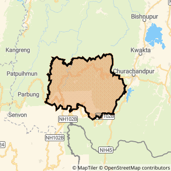
Churachandpur District Map
Current Corona Virus Infected Patients Count in Churachandpur District
| City Name | District Name | Total Covid cases |
|---|
Churachandpur Live Weather
Temperature: 12.3 °C
clear sky
Humidity: 85%
Wind : 0.89 mt/sec towards NE
StationName : "ChurÄ\u0081chÄ\u0081ndpur"
observed on 2 Hours Back
Temperature: 12.3 °C
clear sky
Humidity: 85%
Wind : 0.89 mt/sec towards NE
StationName : "ChurÄ\u0081chÄ\u0081ndpur"
observed on 2 Hours Back
Churachandpur Weather Forecast for Next 5 days
05-01-2026
5.5°C to 20.7°C
clear sky
5.5°C to 20.7°C
clear sky
06-01-2026
5.1°C to 21.1°C
clear sky
5.1°C to 21.1°C
clear sky
07-01-2026
5.4°C to 21.9°C
clear sky
5.4°C to 21.9°C
clear sky
08-01-2026
6.3°C to 22.0°C
clear sky, few clouds, broken clouds, overcast clouds
6.3°C to 22.0°C
clear sky, few clouds, broken clouds, overcast clouds
09-01-2026
6.3°C to 22.3°C
broken clouds, clear sky, scattered clouds
6.3°C to 22.3°C
broken clouds, clear sky, scattered clouds
Temples in Churachandpur
Historical Daily Min/Max Temperatures (Next 7 Days)
| Years | 03 Jan | 04 Jan | 05 Jan | 06 Jan | 07 Jan | 08 Jan | 09 Jan |
|---|---|---|---|---|---|---|---|
| 2025 | |||||||
| 2024 | |||||||
| 2023 |
About Churachandpur District
Churachandpur District is one among 9 Districts of Manipur State ,India. Churachandpur District Administrative head quarter is Churachandpur. It is is Located 66 KM North towards State capital Imphal . Churachandpur District population is 271274. It is 5 th Largest District in the State by population.Geography and Climate Churachandpur District
It is Located at Latitude-24.3, Longitude-93.7. Churachandpur District is sharing border with Chandel District to the East . Churachandpur District occupies an area of approximately 4570 square kilometres. . Its in the 41 meters to meters elevation range.This District belongs to Eastern India .DemoGraphics of Churachandpur District
Meiteilon (manipuri) is the Local Language here. Churachandpur District is divided into 11 Tehsils , 175 Panchayats , 729 Villages. Singngat Tehsil is the Smallest Tehsil by population with 19903 population. Churachandpur Tehsil is the Biggest Tehsil by population with 132156 population.Census 2011 of Churachandpur District
Churachandpur district Total population is 271274 according to census 2011.Males are 137772 and Females are 133502 .Literate people are 179475 among total.Its total area is 4570 sq.km. It is the 5 th largest district in the state by Population . But 1 st Largest District in the state By Area. 564 th Largest District in the Country By Population. 2 nd highest District in the State By literacy rate. 91 st highest District in the Country By literacy rate.its literacy Rate is 84.29Politics in Churachandpur District
Bharatiya Janata Party , Naga Peoples Front , INC are the major political parties in Churachandpur District.Assembly constituencies in Churachandpur District
Total 8 Assembly constituencies in Churachandpur District.| Constituency name | MLA name | Party |
|---|---|---|
| Kumbi | Sanasam Premchandra Singh | INC |
| Jiribam | Md. Achab Uddin | INC |
| Tipaimukh | Ngursanglur Sanate | INC |
| Thanlon | Vungzagin Valte | INC |
| Henglep | Letzamang Haokip | INC |
| Churachandpur | L.M. Khaute | INC |
Parliament constituencies in Churachandpur District
Total 2 Parliament constituencies in Churachandpur District.| Constituency name | MP name | Party |
|---|---|---|
| Inner Manipur | DR RAJKUMAR RANJAN SINGH | Bharatiya Janata Party |
| Outer Manipur | Lorho S. Pfoze | Naga Peoples Front |
Churachandpur District Political Map
Churachandpur Commerce
Total Registered Comapnies with Ministry of Corporate Affairs (MCA) in Churachandpur are 6Company Name : CHIBAI INITIATIVE DEVELOPMENT
Type Of Business : Community, personal & Social Services
Capital : 7.0 Lakhs
Company Name : MANATAM TEA COMPANY PRIVATE LIMITED
Type Of Business : Manufacturing (Food stuffs)
Capital : 1.5 Lakhs
Company Name : LOULHOUMI ORGANIC PRODUCER COMPANY LIMITED
Type Of Business : Agriculture and Allied Activities
Capital : 1.0 Lakhs
Company Name : THRUST TRADING AND INDUSTRY PRIVATE LIMITED
Type Of Business : Real Estate and Renting
Capital : 1.0 Lakhs
More Churachandpur Registered Companies
Churachandpur District Tourism
Churachandpur Transport
Road Transport
District Headquarters Churachandpur is well connected by road . Churachandpur is about 66 KM by road to Imphal( Capital of Manipur )Rail Transport
Bus Transport
Pin Codes in Churachandpur District
795143
( Thanlon ) ,
795139
( Singhat ) ,
795118
( Saikul ) ,
795117
( Saikot ) ,
795128
( Churachandpur ) ,
795158
( Chingkonpang) ,
more PinCodes
Hotels in Churachandpur
Near Cities
Kakching 38 KM near
Mayang Imphal 38 KM near
Lilong 49 KM near
Thoubal 50 KM near
Near By Air Ports
Imphal Municipal Airport 56 KM near
Kumbhirgram Airport 107 KM near
Aizawl Airport 137 KM near
Dimapur Airport 190 KM near
Near By Districts
Churachandpur 0 KM near
Chandel 34 KM near
Bishnupur 35 KM near
Thoubal 50 KM near