| Home | City Bus | Maps | Villages | Cities | Rail | Tourist Places | School | College | Pin Codes | Corona Cases Count |
| Distance Calculator Bus Services IFSC Codes Trace Mobile Number Weather Search Place Trace IP Available Cash ATM/Banks Locate Polling Booth Report an Error contact People |
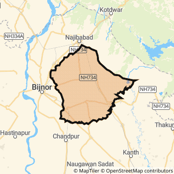
Bijnor District.
Currently In:
India >>
Uttar Pradesh
Division : Moradabad
Head Quarters : Bijnor
Language : Hindi and Urdu
Area: 4049 sq. km
Population : 3683896
Sex Ratio : 913
Density : 808/ sq. km
Literacy : 70.43
Elevation / Altitude: 269 - 224 meters. Above Seal level
Current Time 07:56 PM
Date: Thursday , Jan 01,2026 (IST)
Time zone: IST (UTC+5:30)
District Pin code Index: 246XXX
Vehicle Registration Number: UP-20
RTO Office: Bijnor
Tourist Places near Bijnor
Hastinapur Meerut Roorkee Haridwar Lansdowne (Kaludanda) Corbett National Park (Jim Corbett)
Hastinapur Meerut Roorkee Haridwar Lansdowne (Kaludanda) Corbett National Park (Jim Corbett)
Bijnor District Map
Current Corona Virus Infected Patients Count in Bijnor District
| City Name | District Name | Total Covid cases |
|---|---|---|
| Bijnor District | Bijnor | 2 |
Bijnor Live Weather
Temperature: 15.1 °C
clear sky
Humidity: 43%
Wind : 1.1 mt/sec towards W
StationName : "Bijnor"
observed on 1 Hours Back
Temperature: 15.1 °C
clear sky
Humidity: 43%
Wind : 1.1 mt/sec towards W
StationName : "Bijnor"
observed on 1 Hours Back
Bijnor Weather Forecast for Next 5 days
02-01-2026
11.2°C to 15.4°C
scattered clouds, few clouds, clear sky
11.2°C to 15.4°C
scattered clouds, few clouds, clear sky
03-01-2026
10.2°C to 22.1°C
clear sky
10.2°C to 22.1°C
clear sky
04-01-2026
9.2°C to 21.5°C
clear sky
9.2°C to 21.5°C
clear sky
05-01-2026
9.2°C to 21.9°C
clear sky
9.2°C to 21.9°C
clear sky
06-01-2026
8.4°C to 22.4°C
clear sky, few clouds
8.4°C to 22.4°C
clear sky, few clouds
Temples in Bijnor
Historical Daily Max Temperatures (Next 7 Days)
| Years | 01 Jan | 02 Jan | 03 Jan | 04 Jan | 05 Jan | 06 Jan | 07 Jan |
|---|---|---|---|---|---|---|---|
| 2025 | |||||||
| 2024 | |||||||
| 2023 |
About Bijnor District
Bijnor District is one among 71 Districts of Uttar Pradesh State ,India. Bijnor District Administrative head quarter is Bijnor. It is is Located 461 KM East towards State capital Lucknow . Bijnor District population is 3683896. It is 17 th Largest District in the State by population.Geography and Climate Bijnor District
It is Located at Latitude-29.3, Longitude-78.1. Bijnor District is sharing border with Farrukhabad District to the South , Meerut District to the South , Moradabad District to the East , Muzaffarnagar District to the west , Pauri Garhwal District to the North . It is sharing Border with Uttarakhand State to the East . Bijnor District occupies an area of approximately 4049 square kilometres. . Its in the 269 meters to 224 meters elevation range.This District belongs to Hindi Belt India .DemoGraphics of Bijnor District
Hindi is the Local Language here. Also People Speaks Urdu . Bijnor District is divided into 12 Blocks , Panchayats , 2477 Villages.Census 2011 of Bijnor District
Bijnor district Total population is 3683896 according to census 2011.Males are 1925717 and Females are 1758179 .Literate people are 2437266 among total.Its total area is 4049 sq.km. It is the 17 th largest district in the state by Population . But 23 rd Largest District in the state By Area. 74 th Largest District in the Country By Population. 34 th highest District in the State By literacy rate. 378 th highest District in the Country By literacy rate.its literacy Rate is 70.43Politics in Bijnor District
BJP , nCP , SP , BSP are the major political parties in Bijnor District.Assembly constituencies in Bijnor District
Total 8 Assembly constituencies in Bijnor District.| Constituency name | MLA name | Party |
|---|---|---|
| Najibabad | Tasleem Ahmad | BSP |
| Nagina | Manoj Kumar Paras | SP |
| Barhapur | Kunwar Sushant Singh | BSP |
| Dhampur | Ashok Kumar Rana | SP |
| Nehtaur | Omkumar | BSP |
| Bijnor | Suchi | BJP |
Parliament constituencies in Bijnor District
Total 3 Parliament constituencies in Bijnor District.| Constituency name | MP name | Party |
|---|---|---|
| Nagina | GIRISH CHANDRA | Bahujan Samaj Party |
| Moradabad | Dr. S.T. HASAN | Samajwadi Party |
| Bijnor | MALOOK NAGAR | Bahujan Samaj Party |
Bijnor District Political Map
Bijnor Commerce
Total Registered Comapnies with Ministry of Corporate Affairs (MCA) in Bijnor are 409Company Name : DHAMPUR SUGAR MILLS LIMITED
Type Of Business : Manufacturing (Food stuffs)
Capital : 66.3876 Crores
Company Name : P B S FOODS (SUGAR) PRIVATE LIMITED
Type Of Business : Manufacturing (Food stuffs)
Capital : 44.005 Crores
Company Name : UPPER GANGES SUGAR AND INDUSTRIES LIMITED
Type Of Business : Manufacturing (Food stuffs)
Capital : 41.5572 Crores
Company Name : DWARIKESH SUGAR INDUSTRIES LIMITED
Type Of Business : Manufacturing (Food stuffs)
Capital : 34.9301 Crores
More Bijnor Registered Companies
Bijnor District Tourism
Bijnor Transport
Road Transport
District Headquarters Bijnor is well connected by road . Noorpur , Bijnaur , Nagina , Sahaspur , Seohara , Sherkot , Najibabad , Nehtaur are the Cities in this district having road connectivity to major towns and remote villages. Bijnor is about 461 KM by road to Lucknow( Capital of Uttar Pradesh )Rail Transport
Some of the rail way stations in district are Najibabad Junction , Muazzampur Narayan Junction , Dhampur , Nagina , Seohara , Chandpur Siau , Bijnor , Haldaur .... which connects most of the towns and villages in the District.Bus Transport
Uttar Pradesh State Road Transport ( UPSRTC) runs Busses from Major cities to Towns and Villages in this District.
Pin Codes in Bijnor District
246746
( Seohara ) ,
246737
( Rahu Nagli ) ,
246764
( Kotwali (Bijnor)) ,
246731
( Kiratpur ) ,
246761
( Dhampur ) ,
246762
( Nagina (Bijnor)) ,
246747
( Sherkot ) ,
246724
( Badhapur ) ,
246729
( Chandpur Sugar Factory ) ,
246763
( Najibabad ) ,
246723
( Balawali ) ,
246701
( Bijnor ) ,
246728
( Jhalu ) ,
246738
( Khaspura ) ,
246734
( Noorpur ) ,
246736
( Bashta ) ,
246765
( Akbarabad ) ,
246727
( Hassupura ) ,
246768
( Jalalabad (Bijnor) ) ,
246726
( Haldaur ) ,
more PinCodes
Hotels in Bijnor
Near Cities
Bijnaur 0 KM near
Nehtaur 28 KM near
Hastinapur 32 KM near
Nagina 33 KM near
Near By Air Ports
Muzaffarnagar Airport 50 KM near
Dehra Dun Airport 118 KM near
Indira Gandhi International Airport 151 KM near
Pantnagar Airport 152 KM near
Near By Districts
Bijnor 0 KM near
Muzaffarnagar 48 KM near
Meerut 67 KM near
Jyotiba Phule Nagar 68 KM near