| Home | City Bus | Maps | Villages | Cities | Rail | Tourist Places | School | College | Pin Codes | Corona Cases Count |
| Distance Calculator Bus Services IFSC Codes Trace Mobile Number Weather Search Place Trace IP Available Cash ATM/Banks Locate Polling Booth Report an Error contact People |
Balaghat District.
Currently In:
India >>
Madhya Pradesh
Division : Jabalpur
Head Quarters : Balaghat
Language : Hindi and Marathi
Area: 9245 sq. km
Population : 1701156
Sex Ratio : 1021
Density : 184/ sq. km
Literacy : 78.29
Elevation / Altitude: 348 - 295 meters. Above Seal level
Current Time 05:59 AM
Date: Friday , Jan 02,2026 (IST)
Time zone: IST (UTC+5:30)
District Pin code Index: 481XXX
Vehicle Registration Number: MP-50
RTO Office: Balaghat
Tourist Places near Balaghat
Pench National Park Kanha National park Seoni (Siv-nee) Bhandara Kawardha Rajnandgaon
Pench National Park Kanha National park Seoni (Siv-nee) Bhandara Kawardha Rajnandgaon
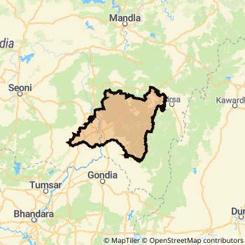
Balaghat District Map
Current Corona Virus Infected Patients Count in Balaghat District
| City Name | District Name | Total Covid cases |
|---|
Balaghat Live Weather
Temperature: 14.8 °C
clear sky
Humidity: 55%
Wind : 2.18 mt/sec towards NE
StationName : "BÄ\u0081lÄ\u0081ghÄ\u0081t"
observed on Now
Temperature: 14.8 °C
clear sky
Humidity: 55%
Wind : 2.18 mt/sec towards NE
StationName : "BÄ\u0081lÄ\u0081ghÄ\u0081t"
observed on Now
Balaghat Weather Forecast for Next 5 days
03-01-2026
16.1°C to 27.7°C
clear sky, few clouds
16.1°C to 27.7°C
clear sky, few clouds
04-01-2026
15.0°C to 27.5°C
clear sky
15.0°C to 27.5°C
clear sky
05-01-2026
14.8°C to 28.7°C
clear sky
14.8°C to 28.7°C
clear sky
06-01-2026
13.2°C to 27.6°C
clear sky
13.2°C to 27.6°C
clear sky
07-01-2026
12.2°C to 27.9°C
clear sky
12.2°C to 27.9°C
clear sky
Temples in Balaghat
Historical Daily Max Temperatures (Next 7 Days)
| Years | 01 Jan | 02 Jan | 03 Jan | 04 Jan | 05 Jan | 06 Jan | 07 Jan |
|---|---|---|---|---|---|---|---|
| 2025 | |||||||
| 2024 | |||||||
| 2023 |
About Balaghat District
Balaghat District is one among 50 Districts of Madhya Pradesh State ,India. Balaghat District Administrative head quarter is Balaghat. It is is Located 382 KM west towards State capital Bhopal . Balaghat District population is 1701156. It is 16 th Largest District in the State by population.Geography and Climate Balaghat District
It is Located at Latitude-21.8, Longitude-80.1. Balaghat District is sharing border with Mandla District to the North , Seoni District to the west , Gondia District to the South . It is sharing Border with Maharashtra State to the west . Balaghat District occupies an area of approximately 9245 square kilometres. . Its in the 348 meters to 295 meters elevation range.This District belongs to Hindi Belt India .DemoGraphics of Balaghat District
Hindi is the Local Language here. Also People Speaks Marathi . Balaghat District is divided into 10 Tehsils , 438 Panchayats , 1287 Villages. Kirnapur Tehsil is the Smallest Tehsil by population with 154407 population. Waraseoni Tehsil is the Biggest Tehsil by population with 443845 population.Census 2011 of Balaghat District
Balaghat district Total population is 1701156 according to census 2011.Males are 841740 and Females are 859416 .Literate people are 1125485 among total.Its total area is 9245 sq.km. It is the 16 th largest district in the state by Population . But 8 th Largest District in the state By Area. 286 th Largest District in the Country By Population. 4 th highest District in the State By literacy rate. 199 th highest District in the Country By literacy rate.its literacy Rate is 78.29Politics in Balaghat District
Independent , Bharatiya Janata Party , BJP , INC are the major political parties in Balaghat District.Assembly constituencies in Balaghat District
Total 6 Assembly constituencies in Balaghat District.| Constituency name | MLA name | Party |
|---|---|---|
| Baihar | Sanjay Uikey | INC |
| Lanji | Rajkumar Karrahe | INC |
| Paraswada | Madhu Bhau Bhagat | BJP |
| Balaghat | Anubha Munjare | BJP |
| Waraseoni | Vivek Vicky Patel | Independent |
| Katangi | Gaurav Singh Pardhi | INC |
Parliament constituencies in Balaghat District
Total 1 Parliament constituencies in Balaghat District.| Constituency name | MP name | Party |
|---|---|---|
| Balaghat | DR DHAL SINGH BISEN | Bharatiya Janata Party |
Balaghat District Political Map
Balaghat Commerce
Total Registered Comapnies with Ministry of Corporate Affairs (MCA) in Balaghat are 78Company Name : GOVIND TILES PRIVATE LIMITED
Type Of Business : Manufacturing (Metals & Chemicals, and products thereof)
Capital : 1.60033 Crores
Company Name : S.R.T.AGRO SCIENCE PRIVATE LIMITED
Type Of Business : Manufacturing (Metals & Chemicals, and products thereof)
Capital : 1.3426 Crores
Company Name : CHORDIA EDIBLE OIL PVT LTD
Type Of Business : Manufacturing (Food stuffs)
Capital : 1.0 Crores
Company Name : DIAMOND SUTRA PRIVATE LIMITED
Type Of Business : Manufacturing (Metals & Chemicals, and products thereof)
Capital : 49.0 Lakhs
More Balaghat Registered Companies
Balaghat District Tourism
Balaghat Transport
Road Transport
District Headquarters Balaghat is well connected by road . Malajkhand , Balaghat , Wara Seoni are the Cities in this district having road connectivity to major towns and remote villages. Balaghat is about 382 KM by road to Bhopal( Capital of Madhya Pradesh )Rail Transport
Some of the rail way stations in district are Balaghat Junction , Birsola , Hatta Road , Lakhanwara , Katangi , Waraseoni , Tirodi , Samnapur .... which connects most of the towns and villages in the District.Bus Transport
Pin Codes in Balaghat District
481117
( Garhi (Balaghat)) ,
481111
( Baihar ) ,
481224
( Karanja (Balaghat)) ,
481102
( Bharveli ) ,
481226
( Hatta (Balaghat)) ,
481449
( Tirodi ) ,
481337
( Khairlanji ) ,
481222
( Lanji ) ,
481441
( Lalbarra ) ,
481105
( Ukwa ) ,
481445
( Katangi (Balaghat)) ,
481331
( Waraseoni ) ,
481335
( Rampaily ) ,
481551
( Lamta ) ,
481556
( Paraswada ) ,
481116
( Malanjkhand ) ,
481332
( Budbuda ) ,
481051
( Birsa ) ,
481001
( Balaghat ) ,
481115
( Kirnapur ) ,
more PinCodes
Hotels in Balaghat
BusStops in Balaghat Lakes in Balaghat Temples in Balaghat Shops in Balaghat Balaghat Hospitals Hotel/Restaurants in Balaghat Balaghat RailwayStations Balaghat BusStops ATM in Balaghat
Near Cities
Balaghat 0 KM near
Wara Seoni 17 KM near
Gondiya 44 KM near
Tirora 58 KM near
Near By Air Ports
Jabalpur Airport 109 KM near
Sonegaon Airport 159 KM near
Raipur Airport 196 KM near
Khajuraho Airport 374 KM near
Near By Districts
Balaghat 0 KM near
Gondia 44 KM near
Seoni 81 KM near
Mandla 99 KM near