| Home | City Bus | Maps | Villages | Cities | Rail | Tourist Places | School | College | Pin Codes | Corona Cases Count |
| Distance Calculator Bus Services IFSC Codes Trace Mobile Number Weather Search Place Trace IP Available Cash ATM/Banks Locate Polling Booth Report an Error contact People |
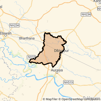
Auraiya District.
Currently In:
India >>
Uttar Pradesh
Division : Kanpur
Head Quarters : Auraiya
Language : Hindi and Urdu
Area: 2054 sq. km
Population : 1372287
Sex Ratio : 864
Density : 681/ sq. km
Literacy : 80.25
Elevation / Altitude: 146 - 139 meters. Above Seal level
Current Time 10:58 AM
Date: Saturday , Jan 03,2026 (IST)
Time zone: IST (UTC+5:30)
District Pin code Index: 206XXX
Vehicle Registration Number: UP-79
RTO Office: Auraiya
Auraiya District Map
Current Corona Virus Infected Patients Count in Auraiya District
| City Name | District Name | Total Covid cases |
|---|---|---|
| Auraiya District | Auraiya | 1 |
Auraiya Live Weather
Temperature: 16.0 °C
clear sky
Humidity: 54%
Wind : 2.04 mt/sec towards W
StationName : "Auraiya"
observed on Now
Temperature: 16.0 °C
clear sky
Humidity: 54%
Wind : 2.04 mt/sec towards W
StationName : "Auraiya"
observed on Now
Auraiya Weather Forecast for Next 5 days
04-01-2026
10.9°C to 20.2°C
clear sky
10.9°C to 20.2°C
clear sky
05-01-2026
9.9°C to 21.1°C
clear sky
9.9°C to 21.1°C
clear sky
06-01-2026
10.0°C to 22.0°C
clear sky
10.0°C to 22.0°C
clear sky
07-01-2026
10.4°C to 23.0°C
clear sky
10.4°C to 23.0°C
clear sky
08-01-2026
11.2°C to 23.3°C
clear sky
11.2°C to 23.3°C
clear sky
Temples in Auraiya
Historical Daily Max Temperatures (Next 7 Days)
| Years | 02 Jan | 03 Jan | 04 Jan | 05 Jan | 06 Jan | 07 Jan | 08 Jan |
|---|---|---|---|---|---|---|---|
| 2025 | |||||||
| 2024 | |||||||
| 2023 |
About Auraiya District
Auraiya District is one among 71 Districts of Uttar Pradesh State ,India. Auraiya District Administrative head quarter is Auraiya. It is is Located 173 KM East towards State capital Lucknow . Auraiya District population is 1372287. It is 64 th Largest District in the State by population.Geography and Climate Auraiya District
It is Located at Latitude-26.4, Longitude-79.5. Auraiya District is sharing border with Etawah District to the west , Kannauj District to the North , Kanpur Dehat District to the East . Auraiya District occupies an area of approximately 2054 square kilometres. . Its in the 146 meters to 139 meters elevation range.This District belongs to Hindi Belt India .DemoGraphics of Auraiya District
Hindi is the Local Language here. Also People Speaks Urdu . Auraiya District is divided into 7 Blocks , Panchayats , 1681 Villages.Census 2011 of Auraiya District
Auraiya district Total population is 1372287 according to census 2011.Males are 736205 and Females are 636082 .Literate people are 907905 among total.Its total area is 2054 sq.km. It is the 64 th largest district in the state by Population . But 55 th Largest District in the state By Area. 355 th Largest District in the Country By Population. 4 th highest District in the State By literacy rate. 169 th highest District in the Country By literacy rate.its literacy Rate is 80.25Politics in Auraiya District
SP , BSP are the major political parties in Auraiya District.Assembly constituencies in Auraiya District
Total 4 Assembly constituencies in Auraiya District.| Constituency name | MLA name | Party |
|---|---|---|
| Bharthana | Raghvendra Kumar Singh | SP |
| Bidhuna | Rekha Verma | SP |
| Dibiyapur | Pradeep Kumar Yadav | SP |
| Auraiya | Gudiya Katheriya | SP |
Parliament constituencies in Auraiya District
Total 2 Parliament constituencies in Auraiya District.| Constituency name | MP name | Party |
|---|---|---|
| Etawah | Dr RAM SHANKAR KATHERIA | Bharatiya Janata Party |
| Kannauj | SUBRAT PATHAK | Bharatiya Janata Party |
Auraiya District Political Map
Auraiya Commerce
Total Registered Comapnies with Ministry of Corporate Affairs (MCA) in Auraiya are 70Company Name : NGG INSUSIN ADVISORY SERVICES LIMITED.
Type Of Business : Business Services
Capital : 2.0 Crores
Company Name : O.P.A. ICE & COLD STORAGE PRIVATE LIMITED
Type Of Business : Agriculture and Allied Activities
Capital : 1.5 Crores
Company Name : RAJA JANMEJAY COLD STORAGE PRIVATE LIMITED
Type Of Business : Agriculture and Allied Activities
Capital : 1.0 Crores
Company Name : RHIZOME ENGINEERS PRIVATE LIMITED
Type Of Business : Manufacturing (Machinery & Equipments)
Capital : 51.0 Lakhs
More Auraiya Registered Companies
Auraiya District Tourism
Auraiya Transport
Road Transport
District Headquarters Auraiya is well connected by road . Auraiya is about 173 KM by road to Lucknow( Capital of Uttar Pradesh )Rail Transport
Some of the rail way stations in district are Phaphund , Achalda , Kanchausi , Pata , Ghasara Halt .... which connects most of the towns and villages in the District.Bus Transport
Uttar Pradesh State Road Transport ( UPSRTC) runs Busses from Major cities to Towns and Villages in this District.
Pin Codes in Auraiya District
206251
( Bela (Auraiya)) ,
206241
( Nevilganj ) ,
206243
( Bidhuna ) ,
206122
( Auraiya ) ,
206246
( Kanchausi Bazar ) ,
206121
( Babarpur (Auraiya)) ,
206247
( Phaphund ) ,
206255
( Malhosi ) ,
206250
( Harchandpur (Auraiya)) ,
206129
( Muradganj ) ,
206249
( Ruruganj ) ,
206248
( Sahar (Auraiya)) ,
206252
( Airwa Katra ) ,
206244
( N. T. P. C. Dibiapur ) ,
more PinCodes
Hotels in Auraiya
Near Cities
Achhalda 32 KM near
Bhajanpura 34 KM near
Pukhrayan 48 KM near
Bharthana 52 KM near
Near By Air Ports
Kanpur Airport 100 KM near
Gwalior Airport 144 KM near
Amausi Airport 157 KM near
Kheria Airport 192 KM near
Near By Districts
Auraiya 0 KM near
Jalaun 44 KM near
Kanpur Dehat 50 KM near
Etawah 66 KM near