| Home | City Bus | Maps | Villages | Cities | Rail | Tourist Places | School | College | Pin Codes | Corona Cases Count |
| Distance Calculator Bus Services IFSC Codes Trace Mobile Number Weather Search Place Trace IP Available Cash ATM/Banks Locate Polling Booth Report an Error contact People |
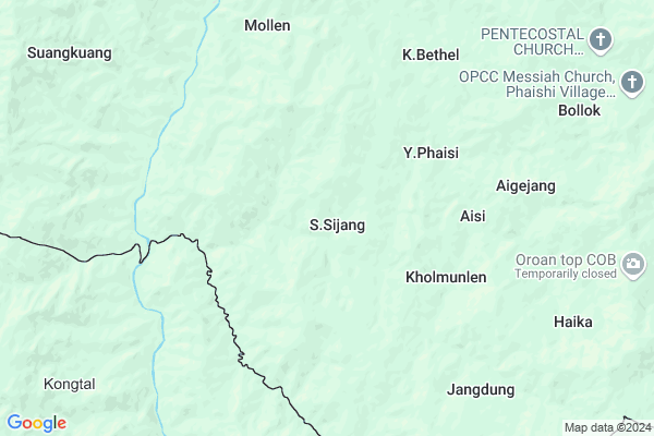
S.sijang
S.sijang Map
EDIT Map
Add Your House
 ..
..
Current Corona Virus Infected Patients Count in Chandel District
| City Name | District Name | Total Covid cases |
|---|
Locality Name :
S.sijang
( S.सीजंग )
Tehsil Name : Chakpikarong
District : Chandel
State : Manipur
Language : Meiteilon (manipuri) and Thadou
Current Time 09:52 PM
Date: Saturday , May 03,2025 (IST)
Time zone: IST (UTC+5:30)
Telephone Code / Std Code: 03878
Assembly constituency : Chandel assembly constituency
Assembly MLA : Ss. Olish
Lok Sabha constituency : Outer Manipur parliamentary constituency
Parliament MP : Lorho S. Pfoze
Serpanch Name :
Pin Code : 795102
Post Office Name : Chakpikarong
Commodities Prices : Bishenpur Market / Mandi
S.sijang Live Weather
Temperature: 16.1 °C
clear sky
Humidity: 94%
Wind : 1.05 mt/sec towards SW
StationName : "ChurÄ\u0081chÄ\u0081ndpur"
observed on Now
Temperature: 16.1 °C
clear sky
Humidity: 94%
Wind : 1.05 mt/sec towards SW
StationName : "ChurÄ\u0081chÄ\u0081ndpur"
observed on Now
S.sijang Weather Forecast for Next 5 days
04-05-2025
15.2°C to 16.1°C
clear sky
15.2°C to 16.1°C
clear sky
05-05-2025
16.3°C to 28.3°C
clear sky, few clouds, light rain, overcast clouds
16.3°C to 28.3°C
clear sky, few clouds, light rain, overcast clouds
06-05-2025
17.7°C to 29.0°C
clear sky, few clouds, overcast clouds, broken clouds, scattered clouds
17.7°C to 29.0°C
clear sky, few clouds, overcast clouds, broken clouds, scattered clouds
07-05-2025
17.2°C to 30.2°C
clear sky, few clouds, broken clouds, scattered clouds, light rain
17.2°C to 30.2°C
clear sky, few clouds, broken clouds, scattered clouds, light rain
08-05-2025
18.5°C to 31.1°C
scattered clouds, clear sky, broken clouds, light rain, overcast clouds
18.5°C to 31.1°C
scattered clouds, clear sky, broken clouds, light rain, overcast clouds
National Highways Reachable To S.sijang
Nationa High Way :NH102B
Nationa High Way :NH102B
Rivers Near S.sijang
Manipur River
Lokchao River
Manipur River
Lokchao River
About S.sijang
Correct below Info and add more info about S.sijangS.sijang is a Village in Chakpikarong Tehsil in Chandel District of Manipur State, India. It is located 48 KM towards South from District head quarters Chandel. 24 KM from Chakpikarong. 105 KM from State capital Imphal
S.sijang Pin code is 795102 and postal head office is Chakpikarong .
K.bethel ( 7 KM ) , Mollen ( 7 KM ) , Jangdung ( 8 KM ) , Phoikon ( 8 KM ) , Khongtal ( 9 KM ) are the nearby Villages to S.sijang. S.sijang is surrounded by Sangaikot Tehsil towards North , Singngat Tehsil towards west , Khengjoy Tehsil towards East , Saikot Tehsil towards North .
Kakching , Mayang Imphal , Thoubal , Lilong are the near by Cities to S.sijang.
This Place is in the border of the Chandel District and Churachandpur District. Churachandpur District Samulamlan is North towards this place .
S.Sijang 2011 Census Details
S.sijang Local Language is Meiteilon (manipuri). S.Sijang Village Total population is 237 and number of houses are 51. Female Population is 50.2%. Village literacy rate is 54.9% and the Female Literacy rate is 24.5%.
Population
| Census Parameter | Census Data |
| Total Population | 237 |
| Total No of Houses | 51 |
| Female Population % | 50.2 % ( 119) |
| Total Literacy rate % | 54.9 % ( 130) |
| Female Literacy rate | 24.5 % ( 58) |
| Scheduled Tribes Population % | 99.2 % ( 235) |
| Scheduled Caste Population % | 0.0 % ( 0) |
| Working Population % | 53.2 % |
| Child(0 -6) Population by 2011 | 56 |
| Girl Child(0 -6) Population % by 2011 | 53.6 % ( 30) |
S.Sijang Census More Deatils.
Politics in S.sijang
NPF , Naga Peoples Front , BJP , PDA , INC are the major political parties in this area.Polling Stations /Booths near S.sijang
1)Aihang2)Molngat
3)Salluk(a)
4)Rungchang
5)New Songjang
HOW TO REACH S.sijang
By Rail
There is no railway station near to S.sijang in less than 10 km.Schools near S.sijang
St.joshep High School
Address : sugnu , chakpikarong , chandel , Manipur . PIN- 795101 , Post - Sugnu
Christian English H S
Address : sugnu , chakpikarong , chandel , Manipur . PIN- 795101 , Post - Sugnu
Standard High School
Address : sugnu , chakpikarong , chandel , Manipur . PIN- 795101 , Post - Sugnu
Grage English School
Address : sugnu , chakpikarong , chandel , Manipur . PIN- 795101 , Post - Sugnu
Govt Health Centers near S.sijang
1) Sugnu CHC , , , Sugnu Bazar2) PHSC Thongam , , , Thongam L.P School
3) PHSC Waikhong , , ,
Schools in S.sijang,Chakpikarong
Electronic Shops in S.sijang,Chakpikarong
Super Markets in S.sijang,Chakpikarong
Local Parks in S.sijang,Chakpikarong
Police Stations near S.sijang,Chakpikarong
Governement Offices near S.sijang,Chakpikarong
About S.sijang &
History
How to reach S.sijang
Tourist Places Near By S.sijang
Schools in S.sijang
Colleges in S.sijang
Temperature & weather of S.sijang
places in S.sijang
S.sijang photos
More Information
How to reach S.sijang
Tourist Places Near By S.sijang
Schools in S.sijang
Colleges in S.sijang
Temperature & weather of S.sijang
places in S.sijang
S.sijang photos
More Information
Village Talk
Post News or Events about this Village
Near Cities
Kakching 64 KM near
Mayang Imphal 74 KM near
Thoubal 81 KM near
Lilong 85 KM near
Kakching 64 KM near
Mayang Imphal 74 KM near
Thoubal 81 KM near
Lilong 85 KM near
Near By Taluks
Chakpikarong 23 KM near
Sangaikot 27 KM near
Singngat 29 KM near
Khengjoy 34 KM near
Chakpikarong 23 KM near
Sangaikot 27 KM near
Singngat 29 KM near
Khengjoy 34 KM near
Near By Air Ports
Imphal Municipal Airport 94 KM near
Aizawl Airport 135 KM near
Kumbhirgram Airport 146 KM near
Dimapur Airport 232 KM near
Imphal Municipal Airport 94 KM near
Aizawl Airport 135 KM near
Kumbhirgram Airport 146 KM near
Dimapur Airport 232 KM near
Near By Tourist Places
Chandel 45 KM near
Thoubal 83 KM near
Champhai 87 KM near
Imphal 100 KM near
Tamenglong 126 KM near
Chandel 45 KM near
Thoubal 83 KM near
Champhai 87 KM near
Imphal 100 KM near
Tamenglong 126 KM near
Near By Districts
Churachandpur 43 KM near
Chandel 46 KM near
Bishnupur 77 KM near
Thoubal 81 KM near
Churachandpur 43 KM near
Chandel 46 KM near
Bishnupur 77 KM near
Thoubal 81 KM near
Near By RailWay Station
Silchar Rail Way Station 153 KM near
Badarpur Junction Rail Way Station 176 KM near
Silchar Rail Way Station 153 KM near
Badarpur Junction Rail Way Station 176 KM near