| Home | City Bus | Maps | Villages | Cities | Rail | Tourist Places | School | College | Pin Codes | Corona Cases Count |
| Distance Calculator Bus Services IFSC Codes Trace Mobile Number Weather Search Place Trace IP Available Cash ATM/Banks Locate Polling Booth Report an Error contact People |
Head Quarters : Senapati
Language : Meiteilon (manipuri) and Aimol
Area: 3269 sq. km
Population : 354972
Sex Ratio : 939
Density : 109/ sq. km
Literacy : 75
Elevation / Altitude: - meters. Above Seal level
Current Time 07:21 AM
Date: Friday , Jan 02,2026 (IST)
Time zone: IST (UTC+5:30)
District Pin code Index: 795XXX
Vehicle Registration Number: MN-03
RTO Office: Kangpokpi
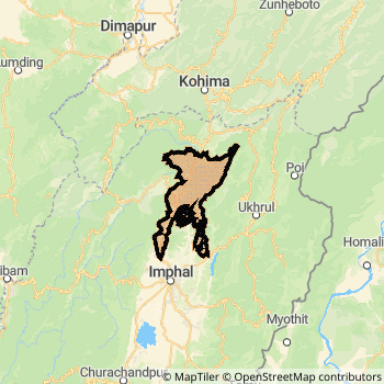
Senapati District Map
Current Corona Virus Infected Patients Count in Senapati District
| City Name | District Name | Total Covid cases |
|---|
Temples in Senapati
Historical Daily Max Temperatures (Next 7 Days)
| Years | 01 Jan | 02 Jan | 03 Jan | 04 Jan | 05 Jan | 06 Jan | 07 Jan |
|---|---|---|---|---|---|---|---|
| 2025 | |||||||
| 2024 | |||||||
| 2023 |
About Senapati District
Senapati District is one among 9 Districts of Manipur State ,India. Senapati District Administrative head quarter is Senapati. It is is Located 60 KM South towards State capital Imphal . Senapati District population is 354972. It is 4 th Largest District in the State by population.Geography and Climate Senapati District
It is Located at Latitude-25.2, Longitude-94.0. Senapati District is sharing border with Tamenglong District to the west , Ukhrul District to the East , Phek District to the North . It is sharing Border with Nagaland State to the North . Senapati District occupies an area of approximately 3269 square kilometres. . Its in the meters to meters elevation range.This District belongs to Eastern India .DemoGraphics of Senapati District
Meiteilon (manipuri) is the Local Language here. Also People Speaks Aimol . Senapati District is divided into 7 Tehsils , Panchayats , 758 Villages.Census 2011 of Senapati District
Senapati district Total population is 354972 according to census 2011.Males are 183070 and Females are 171902 .Literate people are 234849 among total.Its total area is 3269 sq.km. It is the 4 th largest district in the state by Population . But 3 rd Largest District in the state By Area. 555 th Largest District in the Country By Population. 7 th highest District in the State By literacy rate. 260 th highest District in the Country By literacy rate.its literacy Rate is 75Politics in Senapati District
Bharatiya Janata Party , NPF , Naga Peoples Front , MSCP , CPI , INC are the major political parties in Senapati District.Assembly constituencies in Senapati District
Total 9 Assembly constituencies in Senapati District.| Constituency name | MLA name | Party |
|---|---|---|
| Khundrakpam | Thokchom Lokeshwar Singh | INC |
| Saikul | Kimneo Haokip Hangshing | INC |
| Karong | J Kumo Sha | NPF |
| Mao | Losii Dikho | NPF |
| Tadubi | N. Kayisii | INC |
| Kangpokpi | Nemcha Kipgen | MSCP |
Parliament constituencies in Senapati District
Total 2 Parliament constituencies in Senapati District.| Constituency name | MP name | Party |
|---|---|---|
| Inner Manipur | DR RAJKUMAR RANJAN SINGH | Bharatiya Janata Party |
| Outer Manipur | Lorho S. Pfoze | Naga Peoples Front |
Senapati District Political Map
Senapati Commerce
Total Registered Comapnies with Ministry of Corporate Affairs (MCA) in Senapati are 10Company Name : EXOTIC JUICES LIMITED
Type Of Business : Manufacturing (Food stuffs)
Capital : 1.25 Crores
Company Name : EXOTIC CONTRACTORS PRIVATE LIMITED
Type Of Business : Construction
Capital : 1.0 Crores
Company Name : BOTWAYS FARMER PRODUCER COMPANY LIMITED
Type Of Business : Agriculture and Allied Activities
Capital : 2.0 Lakhs
Company Name : JEJO CONSTRUCTION PRIVATE LIMITED
Type Of Business : Construction
Capital : 2.0 Lakhs
More Senapati Registered Companies
Senapati District Tourism
Senapati Transport
Road Transport
District Headquarters Senapati is well connected by road . Senapati is about 60 KM by road to Imphal( Capital of Manipur )Rail Transport
Bus Transport
Pin Codes in Senapati District
795015
( Maram ) ,
795104
( Tadubi ) ,
795007
( Karong ) ,
795112
( T Waichong ) ,
795122
( Kalapahar ) ,
795107
( Motbung ) ,
795129
( Kangpokpi ) ,
795125
( Tamei ) ,
795150
( Mao ) ,
795106
( Senapati ) ,
more PinCodes
Hotels in Senapati
Near Cities
Kohima 51 KM near
Imphal 58 KM near
Lilong 73 KM near
Thoubal 79 KM near
Near By Air Ports
Imphal Municipal Airport 64 KM near
Dimapur Airport 81 KM near
Kumbhirgram Airport 126 KM near
Rowriah Airport 183 KM near
Near By Districts
Senapati 0 KM near
Ukhrul 40 KM near
Peren 44 KM near
Kohima 52 KM near