| Home | City Bus | Maps | Villages | Cities | Rail | Tourist Places | School | College | Pin Codes | Corona Cases Count |
| Distance Calculator Bus Services IFSC Codes Trace Mobile Number Weather Search Place Trace IP Available Cash ATM/Banks Locate Polling Booth Report an Error contact People |
Division : Saran
Head Quarters : Chhapra
Language : Maithili and Bhojpuri, Hindi, Urdu
Area: 2641 sq. km
Population : 3943098
Sex Ratio : 949
Density : 1493/ sq. km
Literacy : 68.57
Elevation / Altitude: 64 - 55 meters. Above Seal level
Current Time 04:54 AM
Date: Friday , Jan 02,2026 (IST)
Time zone: IST (UTC+5:30)
District Pin code Index: 841XXX
Vehicle Registration Number:
RTO Office:
Tourist Places near Saran
Vaishali Golghar (Round house) Patna Takht Sri Patna Sahib Agam Kuan (unfathomable well) Kesariya
Vaishali Golghar (Round house) Patna Takht Sri Patna Sahib Agam Kuan (unfathomable well) Kesariya
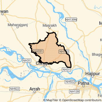
Saran District Map
Current Corona Virus Infected Patients Count in Saran District
| City Name | District Name | Total Covid cases |
|---|
Saran Live Weather
Temperature: 11.0 °C
clear sky
Humidity: 50%
Wind : 1.78 mt/sec towards W
StationName : "Revelganj"
observed on 1 Hours Back
Temperature: 11.0 °C
clear sky
Humidity: 50%
Wind : 1.78 mt/sec towards W
StationName : "Revelganj"
observed on 1 Hours Back
Saran Weather Forecast for Next 5 days
03-01-2026
10.0°C to 22.4°C
clear sky
10.0°C to 22.4°C
clear sky
04-01-2026
10.8°C to 23.3°C
clear sky
10.8°C to 23.3°C
clear sky
05-01-2026
11.0°C to 23.1°C
clear sky
11.0°C to 23.1°C
clear sky
06-01-2026
10.2°C to 22.6°C
clear sky
10.2°C to 22.6°C
clear sky
Temples in Saran
The Hariharnath Temple
The Hariharnath Temple
Historical Daily Max Temperatures (Next 7 Days)
| Years | 01 Jan | 02 Jan | 03 Jan | 04 Jan | 05 Jan | 06 Jan | 07 Jan |
|---|---|---|---|---|---|---|---|
| 2025 | |||||||
| 2024 | |||||||
| 2023 |
About Saran District
Saran District is one among 38 Districts of Bihar State ,India. Saran District Administrative head quarter is Chhapra. It is is Located 50 KM East towards State capital Patna . Saran District population is 3943098. It is 7 th Largest District in the State by population.Geography and Climate Saran District
It is Located at Latitude-25.7, Longitude-84.7. Saran District is sharing border with Patna District to the East , Siwan District to the North , Vaishali District to the East . Saran District occupies an area of approximately 2641 square kilometres. . Its in the 64 meters to 55 meters elevation range.This District belongs to Hindi Belt India .DemoGraphics of Saran District
Maithili is the Local Language here. Also People Speaks Bhojpuri, Hindi, Urdu . Saran District is divided into 20 Blocks , 332 Panchayats , 376 Villages. Lahladpur Block is the Smallest Block by population with 70078 population. Chhapra Block is the Biggest Block by population with 363036 population.Major producing Items,Crops,Industries and Exports from Saran District
Basket, Leather, Pottery, Rice are the major producing Items and Exports from here.Census 2011 of Saran District
Saran district Total population is 3943098 according to census 2011.Males are 2023139 and Females are 1919959 .Literate people are 2608754 among total.Its total area is 2641 sq.km. It is the 7 th largest district in the state by Population . But 17 th Largest District in the state By Area. 60 th Largest District in the Country By Population. 10 th highest District in the State By literacy rate. 423 rd highest District in the Country By literacy rate.its literacy Rate is 68.57Politics in Saran District
JD(U) , LJP , Bharatiya Janata Party , BJP , RJD are the major political parties in Saran District.Assembly constituencies in Saran District
Total 10 Assembly constituencies in Saran District.| Constituency name | MLA name | Party |
|---|---|---|
| Ekma | Srikant Yadav | JD(U) |
| Manjhi | Dr. Satyendra Yadav | JD(U) |
| Baniapur | Kedar Nath Singh | RJD |
| Taraiya | Janak Singh | BJP |
| Marhaura | Jitendra Kumar Ray | RJD |
| Chapra | Dr. C. N. Gupta | BJP |
Parliament constituencies in Saran District
Total 2 Parliament constituencies in Saran District.| Constituency name | MP name | Party |
|---|---|---|
| Maharajganj | Janardan Singh 'Sigriwal" | Bharatiya Janata Party |
| Saran | Rajiv Pratap Rudy | Bharatiya Janata Party |
Saran District Political Map
Saran Commerce
Total Registered Comapnies with Ministry of Corporate Affairs (MCA) in Saran are 449Company Name : SARASWATI COMPONENT MOTORS PRIVATE LIMITED
Type Of Business : Trading
Capital : 6.9795 Crores
Company Name : PAVITRA AGROTECH PRIVATE LIMITED
Type Of Business : Transport, storage and Communications
Capital : 5.4981 Crores
Company Name : ATUL MACHINERY TRADING (INDIA) PRIVATE LIMITED
Type Of Business : Manufacturing (Machinery & Equipments)
Capital : 2.63945 Crores
Company Name : J. K. ENGICON PRIVATE LIMITED
Type Of Business : Construction
Capital : 2.44492 Crores
More Saran Registered Companies
Saran District Tourism
Temples in Saran District
The Hariharnath Temple are the famous temple in Saran DistrictSaran Transport
Road Transport
District Headquarters Chhapra is well connected by road . Marhaura , Chhapra , Dighwara , Sonepur , Revelganj are the Cities in this district having road connectivity to major towns and remote villages. Chhapra is about 50 KM by road to Patna( Capital of Bihar )Rail Transport
Some of the rail way stations in district are Chhapra Junction , Hajipur Junction , Sonpur Junction , Dighwara , Ekma , Chhapra Kacheri , Chainwa , Daudpur .... which connects most of the towns and villages in the District.Bus Transport
Bihar State Road Transportation Corporation ( BSTDC) runs Busses from Major cities to Towns and Villages in this District.
Pin Codes in Saran District
841417
( Masrakh ) ,
841301
( Chapra ) ,
841419
( Mirzapur (Saran)) ,
841208
( Ekma ) ,
841217
( Nayagaon ) ,
841105
( T.M.Pal ) ,
841401
( Amnour ) ,
841223
( Mohamadpur ) ,
841312
( Gariba Tola ) ,
841460
( Bhatha Sonho ) ,
841221
( Sitalpur ) ,
841311
( Garkha ) ,
841443
( Gaura (Saran)) ,
841421
( Sarhwara ) ,
841205
( Daudpur (Saran)) ,
841220
( Parsagarh ) ,
841412
( Jalalpur Bazar ) ,
841212
( Jogia ) ,
841219
( Parsa ) ,
841207
( Dighwara ) ,
more PinCodes
Hotels in Saran
Aniket Hotel
Peetambar Nagar, Bihta Chowk, Patna - 801103, India
Patna
Contact No: 06115 - 294111, 8809560660
Email: deepika.construction@rediffmail.com
Price Range : Rs. 400 - Rs. 2000
Ambapali Vihar
Vaishali H.O. Vaishali - 844128, India
Vaishali
Contact No: 0621 - 2228512
Price Range : Rs. 350 - Rs. 500
Lichhwi Hotel
Dak Bunglow rd;; Hajipur; Bihar
Vaishali
Price Range : Rs. 400 - Rs. 800
Anamika Hotel
M.G Setu rd; Paswan Chowk; Hajipur; Bihar
Vaishali
Price Range : Rs. 1000 - Rs. 1600
BusStops in Saran Lakes in Saran Temples in Saran Shops in Saran Saran Hospitals Hotel/Restaurants in Saran Saran RailwayStations Saran BusStops ATM in Saran
Near Cities
Chhapra 1 KM near
Revelganj 10 KM near
Maner 23 KM near
Marhaura 26 KM near
Near By Air Ports
Patna Airport 46 KM near
Gaya Airport 131 KM near
Gorakhpur Airport 187 KM near
Varanasi Airport 216 KM near
Near By Districts
Saran 0 KM near
Bhojpur 30 KM near
Patna 48 KM near
Vaishali 54 KM near