| Home | City Bus | Maps | Villages | Cities | Rail | Tourist Places | School | College | Pin Codes | Corona Cases Count |
| Distance Calculator Bus Services IFSC Codes Trace Mobile Number Weather Search Place Trace IP Available Cash ATM/Banks Locate Polling Booth Report an Error contact People |
Head Quarters : Daltonganj
Language : Hindi and Santali, Asuri, Bhojpuri
Area: 5044 sq. km
Population : 1936319
Sex Ratio : 929
Density : 381/ sq. km
Literacy : 65.5
Elevation / Altitude: 370 - 143 meters. Above Seal level
Current Time 08:53 PM
Date: Monday , Jan 05,2026 (IST)
Time zone: IST (UTC+5:30)
District Pin code Index: 822XXX
Vehicle Registration Number: JH-03
RTO Office: Daltonganj
Tourist Places near Palamu
Betla National Park Palamu Latehar Rohtasgarh Fort Netarhat Chatra (Atavika)
Betla National Park Palamu Latehar Rohtasgarh Fort Netarhat Chatra (Atavika)
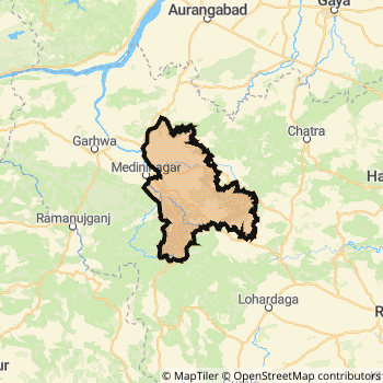
Palamu District Map
Current Corona Virus Infected Patients Count in Palamu District
| City Name | District Name | Total Covid cases |
|---|
Palamu Live Weather
Temperature: 13.3 °C
clear sky
Humidity: 32%
Wind : 1.36 mt/sec towards NW
StationName : "Medininagar"
observed on 1 Hours Back
Temperature: 13.3 °C
clear sky
Humidity: 32%
Wind : 1.36 mt/sec towards NW
StationName : "Medininagar"
observed on 1 Hours Back
Palamu Weather Forecast for Next 5 days
06-01-2026
7.1°C to 13.5°C
clear sky
7.1°C to 13.5°C
clear sky
07-01-2026
6.0°C to 22.9°C
clear sky
6.0°C to 22.9°C
clear sky
08-01-2026
7.9°C to 24.3°C
clear sky, scattered clouds
7.9°C to 24.3°C
clear sky, scattered clouds
09-01-2026
8.5°C to 24.1°C
broken clouds, overcast clouds, scattered clouds, clear sky, few clouds
8.5°C to 24.1°C
broken clouds, overcast clouds, scattered clouds, clear sky, few clouds
10-01-2026
8.6°C to 24.4°C
overcast clouds, broken clouds
8.6°C to 24.4°C
overcast clouds, broken clouds
Temples in Palamu
Historical Daily Min/Max Temperatures (Next 7 Days)
| Years | 05 Jan | 06 Jan | 07 Jan | 08 Jan | 09 Jan | 10 Jan | 11 Jan |
|---|---|---|---|---|---|---|---|
| 2025 | 23.0°C/ 10.0°C | 26.0°C/ 12.0°C | |||||
| 2024 | 25.0°C/ 14.0°C | 24.0°C/ 9.0°C | |||||
| 2023 | 26.0°C/ 9.0°C | 25.0°C/ 9.0°C |
About Palamu District
Palamu District is one among 24 Districts of Jharkhand State ,India. Palamu District Administrative head quarter is Daltonganj. It is is Located 173 KM East towards State capital Ranchi . Palamu District population is 1936319. It is 6 th Largest District in the State by population.Geography and Climate Palamu District
It is Located at Latitude-24.0, Longitude-84.0. Palamu District is sharing border with Aurangabad District to the North , Chatra District to the East , Garhwa District to the west , Latehar District to the East . It is sharing Border with Bihar State to the North . Palamu District occupies an area of approximately 5044 square kilometres. . Its in the 370 meters to 143 meters elevation range.This District belongs to Hindi Belt India .DemoGraphics of Palamu District
Hindi is the Local Language here. Also People Speaks Santali, Asuri, Bhojpuri . Palamu District is divided into 13 Blocks , 278 Panchayats , 1889 Villages. Satbarwa Block is the Smallest Block by population with 52668 population. Hussainabad Block is the Biggest Block by population with 230894 population.Census 2011 of Palamu District
Palamu district Total population is 1936319 according to census 2011.Males are 1003794 and Females are 932525 .Literate people are 1281069 among total.Its total area is 5044 sq.km. It is the 6 th largest district in the state by Population . But 4 th Largest District in the state By Area. 242 nd Largest District in the Country By Population. 13 th highest District in the State By literacy rate. 478 th highest District in the Country By literacy rate.its literacy Rate is 65.5Politics in Palamu District
Bharatiya Janata Party , BJP , NCP , JVMP , RJD , BSP , INC are the major political parties in Palamu District.Assembly constituencies in Palamu District
Total 5 Assembly constituencies in Palamu District.| Constituency name | MLA name | Party |
|---|---|---|
| Manika | RAMCHANDRA SINGH | INC |
| Panki | KUSHWAHA SHASHI BHUSHAN MEHTA | BJP |
| Daltonganj | ALOK KUMAR CHAURASIYA | BJP |
| Chhatarpur | PUSHPA DEVI | BJP |
| Hussainabad | Kamlesh Kumar Singh | NCP |
Parliament constituencies in Palamu District
Total 2 Parliament constituencies in Palamu District.| Constituency name | MP name | Party |
|---|---|---|
| Chatra | SUNIL KUMAR SINGH | Bharatiya Janata Party |
| Palamu | VISHNU DAYAL RAM | Bharatiya Janata Party |
Palamu District Political Map
Palamu Commerce
Total Registered Comapnies with Ministry of Corporate Affairs (MCA) in Palamu are 236Company Name : RDS & SONS PRIVATE LIMITED
Type Of Business : Manufacturing (Food stuffs)
Capital : 1.0 Crores
Company Name : SUSHILA CARBON & CHEMICALS PRIVATE LIMITED
Type Of Business : Manufacturing (Metals & Chemicals, and products thereof)
Capital : 59.5 Lakhs
Company Name : AVI NAMDHARI REAL ESTATE PRIVATE LIMITED
Type Of Business : Construction
Capital : 46.8 Lakhs
Company Name : SOHSA COMMUNICATION PRIVATE LIMITED
Type Of Business : Trading
Capital : 39.0 Lakhs
More Palamu Registered Companies
Palamu District Tourism
Betla National Park , Palamu , Betla National Park , Kamaldah lake Palamu Fort , Palamu Forts , Kund waterfalls , Suga Bandh Waterfalls , Barwadih are the Tourist destinations to Visit.
Palamu Transport
Road Transport
District Headquarters Daltonganj is well connected by road . Daltonganj , Hussainabad are the Cities in this district having road connectivity to major towns and remote villages. Daltonganj is about 173 KM by road to Ranchi( Capital of Jharkhand )Rail Transport
Some of the rail way stations in district are Garhwa Road Junction , Daltonganj , Nabinagar Road , Japla , Mohammad Ganj , Untari Road , Haidar Nagar , Kechki .... which connects most of the towns and villages in the District.Bus Transport
Pin Codes in Palamu District
822113
( Chhatarpur ) ,
822102
( Daltonganj Collage ) ,
822115
( Haidar Nagar ) ,
822131
( Harihar Ganj (Palamau)) ,
822101
( Daltonganj ) ,
822126
( Satbarwa ) ,
822121
( Nagar Utari ) ,
822110
( Raj Chainpur ) ,
822122
( Panki (Palamau)) ,
822120
( Mohammad Ganj ) ,
822116
( Japla ) ,
822123
( Patan (Palamau)) ,
822117
( Japla C F ) ,
822118
( Lesliganj ) ,
more PinCodes
Hotels in Palamu
Hotel Van Vihar
Betla; Ranchi; Jharkhand; Jharkhand; Pin code- 822111
Betla
Price Range : Rs. 800 - Rs. 1100
Hotel Debjani
Palamau National Park; Near the forest gate of Palamau; Betla; Jharkhand; Pin code- 822111
Betla
Price Range : Rs. 600 - Rs. 800
BusStops in Palamu Lakes in Palamu Temples in Palamu Shops in Palamu Palamu Hospitals Hotel/Restaurants in Palamu Palamu RailwayStations Palamu BusStops ATM in Palamu
Near Cities
Daltonganj 5 KM near
Garhwa 35 KM near
Hussainabad 71 KM near
Chatra 93 KM near
Near By Air Ports
Gaya Airport 132 KM near
Ranchi Airport 168 KM near
Varanasi Airport 223 KM near
Patna Airport 225 KM near
Near By Districts
Palamu 0 KM near
Garhwa 33 KM near
Latehar 60 KM near
Chatra 93 KM near