| Home | City Bus | Maps | Villages | Cities | Rail | Tourist Places | School | College | Pin Codes | Corona Cases Count |
| Distance Calculator Bus Services IFSC Codes Trace Mobile Number Weather Search Place Trace IP Available Cash ATM/Banks Locate Polling Booth Report an Error contact People Surnames |
Region : Telangana
Head Quarters : Nalgonda
Language : Telugu and Urdu
Area: 14200 sq. km
Population : 3483648
Sex Ratio : 982
Density : 245/ sq. km
Literacy : 65.05
Elevation / Altitude: 91 - 103 meters. Above Seal level
Current Time 01:53 PM
Date: Wednesday , Apr 29,2026 (IST)
Time zone: IST (UTC+5:30)
District Pin code Index: 508XXX
Vehicle Registration Number: AP-24
RTO Office: Bhongir,Bibinagar,Miryalaguda,Nalgonda,Suryapet
Tourist Places near Nalgonda
Nagarjunsagar Nagarjunakonda (Nagarjuna Sagar Dam) Hyderabad Khammam Warangal (Orugallu) Srisailam
Nagarjunsagar Nagarjunakonda (Nagarjuna Sagar Dam) Hyderabad Khammam Warangal (Orugallu) Srisailam
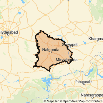
Nalgonda District Map
Current Corona Virus Infected Patients Count in Nalgonda District
| City Name | District Name | Total Covid cases |
|---|
Nalgonda Live Weather
Temperature: 37.5 °C
few clouds
Humidity: 32%
Wind : 1.28 mt/sec towards S
StationName : "Nalgonda"
observed on 2 Hours Back
Temperature: 37.5 °C
few clouds
Humidity: 32%
Wind : 1.28 mt/sec towards S
StationName : "Nalgonda"
observed on 2 Hours Back
Nalgonda Weather Forecast for Next 5 days
30-04-2026
30.3°C to 41.3°C
few clouds, clear sky, scattered clouds, light rain
30.3°C to 41.3°C
few clouds, clear sky, scattered clouds, light rain
01-05-2026
29.2°C to 43.0°C
scattered clouds, clear sky, few clouds, broken clouds, overcast clouds
29.2°C to 43.0°C
scattered clouds, clear sky, few clouds, broken clouds, overcast clouds
02-05-2026
28.4°C to 42.8°C
broken clouds, clear sky, few clouds
28.4°C to 42.8°C
broken clouds, clear sky, few clouds
03-05-2026
28.1°C to 42.0°C
scattered clouds, clear sky, few clouds, broken clouds
28.1°C to 42.0°C
scattered clouds, clear sky, few clouds, broken clouds
04-05-2026
29.0°C to 41.3°C
overcast clouds, clear sky, few clouds, light rain, broken clouds
29.0°C to 41.3°C
overcast clouds, clear sky, few clouds, light rain, broken clouds
Historical Daily Min/Max Temperatures (Next 7 Days)
| Years | 29 Apr | 30 Apr | 01 May | 02 May | 03 May | 04 May | 05 May |
|---|---|---|---|---|---|---|---|
| 2025 | 40.0°C/ 27.0°C | 40.0°C/ 27.0°C | |||||
| 2024 | 42.0°C/ 29.0°C | 43.0°C/ 29.0°C | |||||
| 2023 | 35.0°C/ 23.0°C |
About Nalgonda District
Nalgonda District is one among 10 Districts of Telangana State ,India. It belongs to Telangana Region . Nalgonda District Administrative head quarter is Nalgonda. Nalgonda District population is 3483648. It is 14 th Largest District in the State by population.Geography and Climate Nalgonda District
It is Located at Latitude-17.0, Longitude-79.2. Nalgonda District is sharing border with Guntur District to the East , Khammam District to the East , Krishna District to the East , Mahbubnagar District to the west , Rangareddi District to the west , Warangal District to the North . Nalgonda District occupies an area of approximately 14200 square kilometres. . Its in the 91 meters to 103 meters elevation range.This District belongs to Southern India .DemoGraphics of Nalgonda District
Telugu is the Local Language here. Also People Speaks Urdu . Nalgonda District is divided into 60 Mandals , 1230 Panchayats , 3208 Villages. M.Turka Pally Mandal is the Smallest Mandal by population with 32142 population. Nalgonda Mandal is the Biggest Mandal by population with 163382 population.Major producing Items,Crops,Industries and Exports from Nalgonda District
(Paddy)Rice, AutomobilePart, BambinoSemiya, BasketMaking, Bearings, Beedies, Blackgram, BoiledRice, Bricks, BulkDrugs, Castor, Cement, CementPipes, Chemicals, ChenethaVas-, Chenethaclothe, Chillies, C are the major producing Items and Exports from here.Census 2011 of Nalgonda District
Nalgonda district Total population is 3483648 according to census 2011.Males are 1757643 and Females are 1726005 .Literate people are 2304782 among total.Its total area is 14200 sq.km. It is the 14 th largest district in the state by Population . But 9 th Largest District in the state By Area. 88 th Largest District in the Country By Population. 13 th highest District in the State By literacy rate. 487 th highest District in the Country By literacy rate.its literacy Rate is 65.05Politics in Nalgonda District
TDP , TRS , INC are the major political parties in Nalgonda District.Assembly constituencies in Nalgonda District
Total 12 Assembly constituencies in Nalgonda District.| Constituency name | MLA name | Party |
|---|---|---|
| Devarakonda | Balu Naik Nenavath | TRS |
| Nagarjuna Sagar | Kunduru Jayaveer | TRS |
| Miryalguda | Bathula Laxma Reddy | TRS |
| Huzurnagar | Uttam Kumar Reddy Nalamada | INC |
| Kodad | Nalamada Padmavathi Reddy | TRS |
| Suryapet | Guntakandla Jagadish Reddy | TRS |
Parliament constituencies in Nalgonda District
Total 2 Parliament constituencies in Nalgonda District.| Constituency name | MP name | Party |
|---|---|---|
| Bhongir | Komati Reddy Venkat Reddy | Indian National Congress |
| Nalgonda | UTTAM KUMAR REDDY NALAMADA | Indian National Congress |
Nalgonda District Political Map
Nalgonda Commerce
Total Registered Comapnies with Ministry of Corporate Affairs (MCA) in Nalgonda are 418Company Name : UNITED SEAMLESS TUBULAAR PRIVATE LIMITED
Type Of Business : Manufacturing (Metals & Chemicals, and products thereof)
Capital : 497.4 Crores
Company Name : SITAPURAM POWER LIMITED
Type Of Business : Electricity, Gas & Water companies
Capital : 28.49 Crores
Company Name : SRI VENKATESWARA RICE INDUSTRIES PRIVATE LIMITED
Type Of Business : Manufacturing (Food stuffs)
Capital : 26.5156 Crores
Company Name : KEERTHI INDUSTRIES LIMITED
Type Of Business : Manufacturing (Metals & Chemicals, and products thereof)
Capital : 16.9011 Crores
More Nalgonda Registered Companies
Nalgonda District Tourism
Nagarjunsagar , Chennakesava Swami Temple , Nagarjuna Sagar Dam , Ethipothala Waterfalls , Buddhist Museum are the Tourist destinations to Visit.
Temples in Nalgonda District
Yadagirigutta Narasimha Swamy temple , Sri Sita Rama Anjaneya Swamy temple are the famous temple in Nalgonda DistrictNalgonda Transport
Road Transport
District Headquarters Nalgonda is well connected by road . Devarakonda , Kodad , Suryapet , Miryalaguda , Bhongir are the Cities in this district having road connectivity to major towns and remote villages. Nalgonda is about KM by road to ( Capital of Telangana )Rail Transport
Some of the rail way stations in district are Nalgonda , Miryalaguda , Bhongir , Aler , Bibinagar , Vishnupuram , Ramannapet , Chityala .... which connects most of the towns and villages in the District.Bus Transport
Andhra Pradesh State Transport Corporation ( APSRTC) runs Busses from Major cities to Towns and Villages in this District.
Pin Codes in Nalgonda District
508212
( Sirikonda (Nalgonda)) ,
508254
( Narketpalli ) ,
508111
( Athmakur ) ,
508001
( Nalgonda ) ,
508245
( Marriguda ) ,
508277
( Mothcore ) ,
508234
( Nadigudem ) ,
508201
( Garidepally ) ,
508210
( Vallala ) ,
508243
( Kondamallepalli ) ,
508112
( Valigonda ) ,
508256
( Koppole ) ,
508279
( Phanigiri ) ,
508206
( Kodad ) ,
508101
( Alair ) ,
508248
( Gandhinagar (Nalgonda)) ,
508221
( Noothankal ) ,
508258
( Dindi Project ) ,
508223
( Tirumalgiri ) ,
508126
( Bibinagar ) ,
more PinCodes
Hotels in Nalgonda
Haritha Vijay Vihar
Nagarjuna Sagar Nagarjunasagar - 508202, India
Nagarjunasagar
Contact No: 08680 - 277362
Price Range : Rs. 1200 - Rs. 3000
Samagamam Hotel
Nagarjuna Sagar Hill Colony Nagarjunasagar - 508202, India
Nagarjunasagar
Contact No: 08680 - 277362
Price Range : Rs. 1800 - Rs. 3200
Haritha Hotel- Ettipotala
Ettipotala Water Falls Nagarjunasagar - 508202, India
Nagarjunasagar
Contact No: 08642 - 211100
Price Range : Rs. 600 - Rs. 1100
Sri Vijayadurga Hotel
Near Collectorate; Miryalaguda rd; Nalgonda; Andhra Pradesh; Pin code- 508001
Nalgonda
Price Range : Rs. 400 - Rs. 800
Near Cities
Suryapet 43 KM near
Miryalaguda 46 KM near
Devarakonda 60 KM near
Bhongir 71 KM near
Near By Air Ports
Rajiv Gandhi International Airport 101 KM near
Vijayawada Airport 194 KM near
Rajahmundry Airport 304 KM near
Nanded Airport 351 KM near
Near By Districts
Nalgonda 0 KM near
Hyderabad 105 KM near
Khammam 109 KM near
Warangal 122 KM near