| Home | City Bus | Maps | Villages | Cities | Rail | Tourist Places | School | College | Pin Codes | Corona Cases Count |
| Distance Calculator Bus Services IFSC Codes Trace Mobile Number Weather Search Place Trace IP Available Cash ATM/Banks Locate Polling Booth Report an Error contact People |
Kolhapur District.
Currently In:
India >>
Maharashtra
Region : Desh or Paschim Maharashtra
Division : Pune
Head Quarters : Kolhapur
Language : Marathi and Kannada
Area: 7685 sq. km
Population : 3874015
Sex Ratio : 953
Density : 504/ sq. km
Literacy : 82.9
Elevation / Altitude: 80 - 114 meters. Above Seal level
Current Time 04:29 PM
Date: Monday , Jan 19,2026 (IST)
Time zone: IST (UTC+5:30)
District Pin code Index: 415XXX,416XXX
Vehicle Registration Number: MH-09
RTO Office: Kolhapur
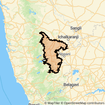
Kolhapur District Map
Current Corona Virus Infected Patients Count in Kolhapur District
| City Name | District Name | Total Covid cases |
|---|---|---|
| Kolhapur District | Kolhapur | 4 |
Kolhapur Live Weather
Temperature: 30.4 °C
clear sky
Humidity: 23%
Wind : 1.73 mt/sec towards SW
StationName : "KolhÄ\u0081pur"
observed on 34 Mins Back
Temperature: 30.4 °C
clear sky
Humidity: 23%
Wind : 1.73 mt/sec towards SW
StationName : "KolhÄ\u0081pur"
observed on 34 Mins Back
Kolhapur Weather Forecast for Next 5 days
20-01-2026
16.8°C to 29.4°C
clear sky
16.8°C to 29.4°C
clear sky
21-01-2026
16.4°C to 30.9°C
clear sky
16.4°C to 30.9°C
clear sky
22-01-2026
17.3°C to 31.0°C
clear sky
17.3°C to 31.0°C
clear sky
23-01-2026
17.7°C to 30.8°C
clear sky
17.7°C to 30.8°C
clear sky
24-01-2026
17.0°C to 31.1°C
clear sky, scattered clouds, few clouds
17.0°C to 31.1°C
clear sky, scattered clouds, few clouds
Temples in Kolhapur
Mahalakshmi Temple Chakreshwar Temple, Rameshwar Mahadev Temple Jyotibacha Khanderaya Mallikarjun Temple Narsoba wadi Kalaheshwar Temple
Mahalakshmi Temple Chakreshwar Temple, Rameshwar Mahadev Temple Jyotibacha Khanderaya Mallikarjun Temple Narsoba wadi Kalaheshwar Temple
Historical Daily Min/Max Temperatures (Next 7 Days)
| Years | 19 Jan | 20 Jan | 21 Jan | 22 Jan | 23 Jan | 24 Jan | 25 Jan |
|---|---|---|---|---|---|---|---|
| 2025 | 31.0°C/ 17.0°C | 31.0°C/ 17.0°C | 32.0°C/ 18.0°C | 33.0°C/ 19.0°C | 33.0°C/ 18.0°C | 33.0°C/ 19.0°C | |
| 2024 | 31.0°C/ 18.0°C | 31.0°C/ 18.0°C | 33.0°C/ 18.0°C | 33.0°C/ 15.0°C | 31.0°C/ 16.0°C | 30.0°C/ 16.0°C | 31.0°C/ 18.0°C |
| 2023 | 31.0°C/ 17.0°C | 31.0°C/ 17.0°C | 30.0°C/ 17.0°C | 30.0°C/ 17.0°C | 31.0°C/ 18.0°C | 30.0°C/ 18.0°C | 27.0°C/ 20.0°C |
About Kolhapur District
Kolhapur District is one among 34 Districts of Maharashtra State ,India. It belongs to Desh or Paschim Maharashtra Region . Kolhapur District Administrative head quarter is Kolhapur. It is is Located 346 KM North towards State capital Mumbai . Kolhapur District population is 3874015. It is 9 th Largest District in the State by population.Geography and Climate Kolhapur District
It is Located at Latitude-16.7, Longitude-74.2. Kolhapur District is sharing border with Belgaum District to the South , Ratnagiri District to the west , Sangli District to the East , Sindhudurg District to the South . It is sharing Border with Karnataka State to the East . Kolhapur District occupies an area of approximately 7685 square kilometres. . Its in the 80 meters to 114 meters elevation range.This District belongs to Western India .DemoGraphics of Kolhapur District
Marathi is the Local Language here. Also People Speaks Kannada . Kolhapur District is divided into 14 Talukas , Panchayats , 1622 Villages.Census 2011 of Kolhapur District
Kolhapur district Total population is 3874015 according to census 2011.Males are 1983623 and Females are 1890392 .Literate people are 2563048 among total.Its total area is 7685 sq.km. It is the 9 th largest district in the state by Population . But 20 th Largest District in the state By Area. 65 th Largest District in the Country By Population. 13 th highest District in the State By literacy rate. 114 th highest District in the Country By literacy rate.its literacy Rate is 82.9Politics in Kolhapur District
JSPI , BJP , NCP , JSS , Shivsena , SWP , INC , SHS are the major political parties in Kolhapur District.Assembly constituencies in Kolhapur District
Total 10 Assembly constituencies in Kolhapur District.| Constituency name | MLA name | Party |
|---|---|---|
| Chandgad | Rajesh Narasingrao Patil | NCP |
| Radhanagari | Abitkar Prakash Anandrao | SHS |
| Kagal | Mushrif Hasan Miyalal | NCP |
| Kolhapur South | Ruturaj Sanjay Patil | INC |
| Karvir | P. N.Patil (Sadolikar) | INC |
| Kolhapur North | Chandrakant Pandit Jadhav | INC |
Parliament constituencies in Kolhapur District
Total 2 Parliament constituencies in Kolhapur District.| Constituency name | MP name | Party |
|---|---|---|
| Kolhapur | Sanjay Sadashivrao Mandlik | Shivsena |
| Hatkanangle | Dhairyasheel Sambhajirao Mane | Shivsena |
Kolhapur District Political Map
Kolhapur Commerce
Total Registered Comapnies with Ministry of Corporate Affairs (MCA) in Kolhapur are 3265Company Name : RBL BANK LIMITED
Type Of Business : Finance
Capital : 419.668 Crores
Company Name : RBL BANK LIMITED
Type Of Business : Finance
Capital : 411.926 Crores
Company Name : SOKTAS INDIA PRIVATE LIMITED
Type Of Business : Manufacturing (Metals & Chemicals; and products thereof)
Capital : 113.091 Crores
Company Name : GRI POWERGEAR TOWERS INDIA PRIVATE LIMITED
Type Of Business : Business Services
Capital : 102.237 Crores
More Kolhapur Registered Companies
Kolhapur District Tourism
Durshet , Kolhapur , Panhala , Shri Ballaleshwar Ashtavinayaka , Pali Ganapati temple , Jungle Safari Koyna , Kaalammavadi , Radhanagari Dam , Sajja Kothi , Botanical Gardens , TeenDarwaza , are the Tourist destinations to Visit.
Temples in Kolhapur District
Mahalakshmi Temple , Chakreshwar Temple, , Rameshwar Mahadev Temple , Jyotibacha Khanderaya , Mallikarjun Temple , Narsoba wadi , Kalaheshwar Temple are the famous temple in Kolhapur DistrictKolhapur Transport
Road Transport
District Headquarters Kolhapur is well connected by road . Kolhapur , Ichalkaranji , Nipani , Uchgaon , Vadgaon Kasba are the Cities in this district having road connectivity to major towns and remote villages. Kolhapur is about 346 KM by road to Mumbai( Capital of Maharashtra )Rail Transport
Some of the rail way stations in district are Kolhapur Scsmt , Hatkanagale , Valivade , Rukadi , Shedbal , Nimshirgaon Tamdalge .... which connects most of the towns and villages in the District.Bus Transport
Maharashtra State Road Transportation ( MSRTC) runs Busses from Major cities to Towns and Villages in this District.
Pin Codes in Kolhapur District
416212
( Radhanagari ) ,
416235
( Sadashivnagar ) ,
416527
( Tillarinagar ) ,
416502
( Gadhinglaj Tilakpath ) ,
416234
( MIDC Gokul Shirgaon ) ,
416005
( Ruikar Colony ) ,
416013
( R K Nagar (Kolhapur)) ,
416105
( Ganeshwadi (Kolhapur)) ,
416211
( Parite ) ,
416506
( Halkarni ) ,
416007
( Kalamba ) ,
416209
( Gargoti ) ,
416143
( ICO Spinning Mills ) ,
416113
( Warnanagar ) ,
416115
( Ichalkaranji ) ,
416117
( Jawaharnagar Ichalkaranji ) ,
416204
( Kuditre ) ,
416006
( Kasba Bavada ) ,
416231
( Dudhganganagar ) ,
416144
( Akiwate Industrial Estate ) ,
more PinCodes
Hotels in Kolhapur
Sai Internationl Hotel
Pune-Banglore Highway;; Yelur Phata;; Taluka Walwa;; Maharashtra; Pin code- 415411
Sangli
Price Range : Rs. 2200 - Rs. 2400
Raj Hotel
1250 C, Laxmipuri, Kolhapur - 416002
Kolhapur
Contact No: (91)-(231)-2640623
Price Range : Rs. 400 - Rs. 500
Raysons Regency Hotel
204 E Ward, S T Stand, Shahupuri, Kolhapur - 416001
Kolhapur
Contact No: (91)-(231)-6681333
Price Range : Rs. 2000 - Rs. 4000
Pearl Hotel
New Shahupuri Opposite Panchashil Hotel, Main Road Kolhapur, Shahupuri, Kolhapur - 416001
Kolhapur
Contact No: (91)-(231)-6684451
Price Range : Rs. 2000 - Rs. 4000
BusStops in Kolhapur Lakes in Kolhapur Temples in Kolhapur Shops in Kolhapur Kolhapur Hospitals Hotel/Restaurants in Kolhapur Kolhapur RailwayStations Kolhapur BusStops ATM in Kolhapur
Near Cities
Uchgaon 2 KM near
Kolhapur 3 KM near
Vadgaon Kasba 18 KM near
Ichalkaranji 24 KM near
Near By Air Ports
Kolhapur Airport 10 KM near
Sambre Airport 113 KM near
Dabolim Airport 171 KM near
Hubli Airport 194 KM near
Near By Districts
Kolhapur 0 KM near
Sangli 43 KM near
Sindhudurg 99 KM near
Belgaum 110 KM near