| Home | City Bus | Maps | Villages | Cities | Rail | Tourist Places | School | College | Pin Codes | Corona Cases Count |
| Distance Calculator Bus Services IFSC Codes Trace Mobile Number Weather Search Place Trace IP Available Cash ATM/Banks Locate Polling Booth Report an Error contact People |
Division : Kota
Head Quarters : Jhalawar
Language : Hindi and Rajasthani
Area: 6928 sq. km
Population : 1411327
Sex Ratio : 945
Density : 227/ sq. km
Literacy : 62.13
Elevation / Altitude: 430 - 289 meters. Above Seal level
Current Time 06:24 AM
Date: Thursday , Jan 01,2026 (IST)
Time zone: IST (UTC+5:30)
District Pin code Index: 326XXX
Vehicle Registration Number: RJ-17
RTO Office: Jhalawar
Tourist Places near Jhalawar
Jhalawar Kota (Kotah) Bijolia (Beejoliya Kalan) Bundi Guna (string) Neemuch (Nimach)
Jhalawar Kota (Kotah) Bijolia (Beejoliya Kalan) Bundi Guna (string) Neemuch (Nimach)
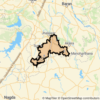
Jhalawar District Map
Current Corona Virus Infected Patients Count in Jhalawar District
| City Name | District Name | Total Covid cases |
|---|
Temples in Jhalawar
Historical Daily Max Temperatures (Next 7 Days)
| Years | 31 Dec | 01 Jan | 02 Jan | 03 Jan | 04 Jan | 05 Jan | 06 Jan |
|---|---|---|---|---|---|---|---|
| 2025 | |||||||
| 2024 | 21.0°C/ 12.0°C | ||||||
| 2023 | 26.0°C/ 14.0°C | ||||||
| 2022 | 14.0°C/ 11.0°C |
About Jhalawar District
Jhalawar District is one among 33 Districts of Rajasthan State ,India. Jhalawar District Administrative head quarter is Jhalawar. It is is Located 303 KM North towards State capital Jaipur . Jhalawar District population is 1411327. It is 24 th Largest District in the State by population.Geography and Climate Jhalawar District
It is Located at Latitude-24.6, Longitude-76.1. Jhalawar District is sharing border with Guna District to the East , Mandsaur District to the west , Shajapur District to the South , Baran District to the North . It is sharing Border with Madhya Pradesh State to the East . Jhalawar District occupies an area of approximately 6928 square kilometres. . Its in the 430 meters to 289 meters elevation range.This District belongs to Hindi Belt India .DemoGraphics of Jhalawar District
Hindi is the Local Language here. Also People Speaks Rajasthani . Jhalawar District is divided into 7 Tehsils , Panchayats , 1405 Villages.Census 2011 of Jhalawar District
Jhalawar district Total population is 1411327 according to census 2011.Males are 725618 and Females are 685709 .Literate people are 933734 among total.Its total area is 6928 sq.km. It is the 24 th largest district in the state by Population . But 21 st Largest District in the state By Area. 347 th Largest District in the Country By Population. 26 th highest District in the State By literacy rate. 539 th highest District in the Country By literacy rate.its literacy Rate is 62.13Politics in Jhalawar District
BJP , INC are the major political parties in Jhalawar District.Assembly constituencies in Jhalawar District
Total 5 Assembly constituencies in Jhalawar District.| Constituency name | MLA name | Party |
|---|---|---|
| Sangod | Heeralal Nagar | INC |
| Dag | Kaluram | BJP |
| Jhalrapatan | Vasundhara Raje | BJP |
| Khanpur | Suresh Gurjar | BJP |
| Manohar Thana | Govind Prasad | BJP |
Parliament constituencies in Jhalawar District
Total 2 Parliament constituencies in Jhalawar District.| Constituency name | MP name | Party |
|---|---|---|
| Kota | OM BIRLA | Bharatiya Janata Party |
| Jhalawar-Baran | DUSHYANT SINGH | Bharatiya Janata Party |
Jhalawar District Political Map
Jhalawar Commerce
Total Registered Comapnies with Ministry of Corporate Affairs (MCA) in Jhalawar are 89Company Name : SUTLEJ TEXTILES AND INDUSTRIES LIMITED
Type Of Business : Manufacturing (Textiles)
Capital : 16.3829 Crores
Company Name : SIL INVESTMENTS LIMITED
Type Of Business : Manufacturing (Textiles)
Capital : 10.5959 Crores
Company Name : BANAS STONES PRIVATE LIMITED
Type Of Business : Mining & Quarrying
Capital : 1.0 Crores
Company Name : BANAS MINERALS PRIVATE LIMITED
Type Of Business : Mining & Quarrying
Capital : 1.0 Crores
More Jhalawar Registered Companies
Jhalawar District Tourism
Jhalawar , Garh Palace , Rain Basera , Bhawani Natya Shala , Prithvi Vilas Palace , Gagron Fort , Jhalrapatan are the Tourist destinations to Visit.
Jhalawar Transport
Road Transport
District Headquarters Jhalawar is well connected by road . Jhalawar is about 303 KM by road to Jaipur( Capital of Rajasthan )Rail Transport
Some of the rail way stations in district are Suwasra , Nathukheri .... which connects most of the towns and villages in the District.Bus Transport
Rajasthan State Road Transport Corporation ( RSRTC) runs Busses from Major cities to Towns and Villages in this District.
Pin Codes in Jhalawar District
326023
( Jhalara Patan City ) ,
326501
( Shrichhattarpur ) ,
326035
( Sarola ) ,
326502
( Bhawanimandi ) ,
326516
( Gangdhar ) ,
326513
( Sunel ) ,
326515
( Chaumahla ) ,
326034
( Pirawa ) ,
326036
( Raipur (Jhalawar)) ,
326033
( Aklera ) ,
326517
( Morak ) ,
326022
( Bakani ) ,
326001
( Jhalawar ) ,
326037
( Manohar Thana ) ,
326021
( Asnawar ) ,
326514
( Dag ) ,
326038
( Khanpur (Jhalawar)) ,
326039
( Ghatoli ) ,
326512
( Pach Pahar ) ,
326030
( Sumar) ,
more PinCodes
Hotels in Jhalawar
Dwarika Hotel
NH 12, , Hospital Road, Jhalawar - 326001, India
Jhalawar
Contact No: 07432 - 232626
Price Range : Rs. 600 - Rs. 1100
Rain Basera
Kota Road, Jhalawar - 326001, India
Jhalawar
Contact No: 07432 - 232349
Price Range : Rs. 200 - Rs. 300
Gavdi Talab Hotel
Dak Bunglow Road, Jhalawar - 326001, India
Jhalawar
Contact No: 07432 - 211265
Price Range : Rs. 1800 - Rs. 1800
Chandrawati Hotel
Patan Road,, NH No.12, Jhalawar - 326001, India
Jhalawar
Contact No: 07432 - 234023
Price Range : Rs. 1000 - Rs. 1200
BusStops in Jhalawar Lakes in Jhalawar Temples in Jhalawar Shops in Jhalawar Jhalawar Hospitals Hotel/Restaurants in Jhalawar Jhalawar RailwayStations Jhalawar BusStops ATM in Jhalawar
Near Cities
Jhalawar 1 KM near
Ramganj Mandi 26 KM near
Baran 73 KM near
Rawatbhata 77 KM near
Near By Air Ports
Bhopal Airport 211 KM near
Indore Airport 236 KM near
Dabok Airport 256 KM near
Sanganeer Airport 279 KM near
Near By Districts
Jhalawar 0 KM near
Baran 73 KM near
Kota 81 KM near
Rajgarh 95 KM near