| Home | City Bus | Maps | Villages | Cities | Rail | Tourist Places | School | College | Pin Codes | Corona Cases Count |
| Distance Calculator Bus Services IFSC Codes Trace Mobile Number Weather Search Place Trace IP Available Cash ATM/Banks Locate Polling Booth Report an Error contact People |
Haridwar District.
Currently In:
India >>
Uttarakhand
Head Quarters : Haridwar
Language : Hindi and Urdu
Area: 2360 sq. km
Population : 1927029
Sex Ratio : 879
Density : 817/ sq. km
Literacy : 74.62
Elevation / Altitude: 312 - 238 meters. Above Seal level
Current Time 11:38 AM
Date: Thursday , Jan 01,2026 (IST)
Time zone: IST (UTC+5:30)
District Pin code Index: 247XXX,249XXX
Vehicle Registration Number: UK-08
RTO Office: Haridwar
Tourist Places near Haridwar
Haridwar Rishikesh (Hrishikesh) Rajaji National Park Roorkee Dehradun Devprayag
Haridwar Rishikesh (Hrishikesh) Rajaji National Park Roorkee Dehradun Devprayag
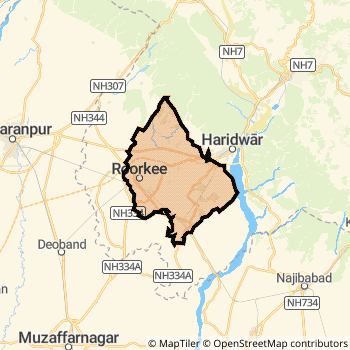
Haridwar District Map
Current Corona Virus Infected Patients Count in Haridwar District
| City Name | District Name | Total Covid cases |
|---|
Temples in Haridwar
Chandi Devi Temple Daksheswara Mahadev Temple Har ki Pauri Mansa Devi Temple Maya Devi Temple
Chandi Devi Temple Daksheswara Mahadev Temple Har ki Pauri Mansa Devi Temple Maya Devi Temple
Historical Daily Max Temperatures (Next 7 Days)
| Years | 01 Jan | 02 Jan | 03 Jan | 04 Jan | 05 Jan | 06 Jan | 07 Jan |
|---|---|---|---|---|---|---|---|
| 2025 | |||||||
| 2024 | |||||||
| 2023 |
About Haridwar District
Haridwar District is one among 13 Districts of Uttarakhand State ,India. Haridwar District Administrative head quarter is Haridwar. It is is Located 50 KM North towards State capital Dehradun . Haridwar District population is 1927029. It is Biggest district in Uttarakhand State by population.Geography and Climate Haridwar District
It is Located at Latitude-29.9, Longitude-78.1. Haridwar District is sharing border with Muzaffarnagar District to the South , Saharanpur District to the west , Pauri Garhwal District to the East . It is sharing Border with Uttar Pradesh State to the South . Haridwar District occupies an area of approximately 2360 square kilometres. . Its in the 312 meters to 238 meters elevation range.This District belongs to Hindi Belt India .DemoGraphics of Haridwar District
Hindi is the Local Language here. Also People Speaks Urdu . Haridwar District is divided into 7 Blocks , Panchayats , 603 Villages.Census 2011 of Haridwar District
Haridwar district Total population is 1927029 according to census 2011.Males are 1025561 and Females are 901468 .Literate people are 1274922 among total.Its total area is 2360 sq.km. It is the 1 st largest district in the state by Population . But 10 th Largest District in the state By Area. 243 rd Largest District in the Country By Population. 12 th highest District in the State By literacy rate. 266 th highest District in the Country By literacy rate.its literacy Rate is 74.62Politics in Haridwar District
INC , BJP , BJP , BSP , INC are the major political parties in Haridwar District.Assembly constituencies in Haridwar District
Total 11 Assembly constituencies in Haridwar District.| Constituency name | MLA name | Party |
|---|---|---|
| Hardwar | Madan Kaushik | BJP |
| B.H.E.L. Ranipur | Adesh Chauhan | BJP |
| Jwalapur | Er. Ravi Bahadur | BJP |
| Bhagwanpur | Mamta Rakesh | BSP |
| Jhabrera | Virendra Kumar | BJP |
| Pirankaliyar | Furkan Ahmad | INC |
Parliament constituencies in Haridwar District
Total 1 Parliament constituencies in Haridwar District.| Constituency name | MP name | Party |
|---|---|---|
| Hardwar | Ramesh Pokhriyal 'Nishank' | Bharatiya Janata Party |
Haridwar District Political Map
Haridwar Commerce
Total Registered Comapnies with Ministry of Corporate Affairs (MCA) in Haridwar are 978Company Name : UTTAM SUGAR MILLS LIMITED
Type Of Business : Others
Capital : 109.788 Crores
Company Name : FORACE POLYMERS PRIVATE LIMITED
Type Of Business : Manufacturing (Food stuffs)
Capital : 40.6978 Crores
Company Name : TEXPLAS TEXTILES INDIA PRIVATE LIMITED
Type Of Business : Manufacturing (Textiles)
Capital : 37.75 Crores
Company Name : SBL PRIVATE LIMITED
Type Of Business : Business Services
Capital : 29.8803 Crores
More Haridwar Registered Companies
Haridwar District Tourism
Haridwar , Rajaji National Park , Roorkee , are the Tourist destinations to Visit.
Temples in Haridwar District
Chandi Devi Temple , Daksheswara Mahadev Temple , Har ki Pauri , Mansa Devi Temple , Maya Devi Temple are the famous temple in Haridwar DistrictHaridwar Transport
Road Transport
District Headquarters Haridwar is well connected by road . Manglaur , Purquazi , Haridwar , Roorkee are the Cities in this district having road connectivity to major towns and remote villages. Haridwar is about 50 KM by road to Dehradun( Capital of Uttarakhand )Rail Transport
Some of the rail way stations in district are Roorkee , Haridwar , Laksar Junction , Raiwala Junction , Jwalapur , Motichur , Aithal , Dausni .... which connects most of the towns and villages in the District.Bus Transport
Uttaranchal transport ( UTC) runs Busses from Major cities to Towns and Villages in this District.
Pin Codes in Haridwar District
249405
( Patanjali Yogpeeth ) ,
249410
( Sadhubela Bhupatwala ) ,
247665
( Jhabrera ) ,
249407
( Jwalapur Town ) ,
249411
( Shantikunj ) ,
247670
( Gurkul Narsan ) ,
249401
( Mayapur (Haridwar)) ,
247656
( Manglour Town ) ,
247668
( Iqbalpur ) ,
249404
( Gurukul Pharmecy ) ,
247666
( Milap Nagar ) ,
247663
( Lokoshed Laksar ) ,
247667
( Roorkee ) ,
249408
( Kankhal ) ,
247664
( Landhaura ) ,
247671
( Raisi ) ,
247661
( Bhagwanpur (Haridwar)) ,
249402
( Bahadrabad ) ,
249403
( Shivalik Nagar ) ,
more PinCodes
Hotels in Haridwar
Hotel Royal Palace
22 Civil Lines, Near Roorkee Talkies Roorkee - 247667, India
Roorkee
Contact No: 01332 - 272678
Email: info@hotelroyalpalace.org
Price Range : Rs. 800 - Rs. 2000
Centrum Hotel
Delhi Road, Opp: Maruti Shakumbari Roorkee - 247667, India
Roorkee
Contact No: 01332 - 242411, 242422, 9756207194, 9756207191
Email: hotelscentrum@yahoo.in
Price Range : Rs. 2000 - Rs. 4000
Sagar Hotel & Restaurant
19, Civil Lines, Garhwal Roorkee - 247667, India
Roorkee
Contact No: 01332 - 271600, 9927094500
Price Range : Rs. 1200 - Rs. 2300
Center Point Hotel
24 Civil Lines Roorkee - 247667, India
Roorkee
Contact No: 01332 - 273040, 274050
Email: hotelcp@in.com
Price Range : Rs. 1600 - Rs. 2500
Near Cities
Haridwar 9 KM near
Rishikesh 18 KM near
Roorkee 31 KM near
Manglaur 36 KM near
Near By Air Ports
Dehra Dun Airport 47 KM near
Muzaffarnagar Airport 83 KM near
Chandigarh Airport 172 KM near
Simla Airport 181 KM near
Near By Districts
Haridwar 0 KM near
Dehradun 49 KM near
Saharanpur 64 KM near
Tehri Garhwal 64 KM near