| Home | City Bus | Maps | Villages | Cities | Rail | Tourist Places | School | College | Pin Codes | Corona Cases Count |
| Distance Calculator Bus Services IFSC Codes Trace Mobile Number Weather Search Place Trace IP Available Cash ATM/Banks Locate Polling Booth Report an Error contact People |
Hamirpur District.
Currently In:
India >>
Himachal Pradesh
Head Quarters : Hamirpur
Language : Hindi
Area: 1118 sq. km
Population : 454293
Sex Ratio : 1096
Density : 406/ sq. km
Literacy : 89.01
Elevation / Altitude: 478 - 1081 meters. Above Seal level
Current Time 10:05 AM
Date: Friday , Jan 02,2026 (IST)
Time zone: IST (UTC+5:30)
District Pin code Index: 174XXX,176XXX,177XXX
Vehicle Registration Number: HP-21,HP-22,HP-55,HP-67,HP-74
RTO Office: Barsar,Bhoranj,Hamirpur,Nadaun
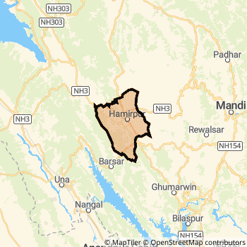
Hamirpur District Map
Current Corona Virus Infected Patients Count in Hamirpur District
| City Name | District Name | Total Covid cases |
|---|
Hamirpur Live Weather
Temperature: 11.7 °C
clear sky
Humidity: 38%
Wind : 1.25 mt/sec towards E
StationName : "Hamīrpur"
observed on 18 Mins Back
Temperature: 11.7 °C
clear sky
Humidity: 38%
Wind : 1.25 mt/sec towards E
StationName : "Hamīrpur"
observed on 18 Mins Back
Hamirpur Weather Forecast for Next 5 days
03-01-2026
8.0°C to 19.6°C
clear sky, overcast clouds
8.0°C to 19.6°C
clear sky, overcast clouds
04-01-2026
7.7°C to 19.7°C
overcast clouds, broken clouds, scattered clouds, clear sky
7.7°C to 19.7°C
overcast clouds, broken clouds, scattered clouds, clear sky
05-01-2026
7.1°C to 19.7°C
clear sky
7.1°C to 19.7°C
clear sky
06-01-2026
6.8°C to 20.5°C
clear sky, broken clouds
6.8°C to 20.5°C
clear sky, broken clouds
07-01-2026
7.5°C to 21.4°C
broken clouds, scattered clouds, clear sky, few clouds
7.5°C to 21.4°C
broken clouds, scattered clouds, clear sky, few clouds
Temples in Hamirpur
Historical Daily Max Temperatures (Next 7 Days)
| Years | 01 Jan | 02 Jan | 03 Jan | 04 Jan | 05 Jan | 06 Jan | 07 Jan |
|---|---|---|---|---|---|---|---|
| 2025 | |||||||
| 2024 | |||||||
| 2023 |
About Hamirpur District
Hamirpur District is one among 12 Districts of Himachal Pradesh State ,India. Hamirpur District Administrative head quarter is Hamirpur. It is is Located 104 KM South towards State capital Shimla . Hamirpur District population is 454293. It is 8 th Largest District in the State by population.Geography and Climate Hamirpur District
It is Located at Latitude-31.6, Longitude-76.5. Hamirpur District is sharing border with Bilaspur District District to the South , Kangra District to the North , Mandi District to the East , Una District to the South . Hamirpur District occupies an area of approximately 1118 square kilometres. . Its in the 478 meters to 1081 meters elevation range.This District belongs to Hindi Belt India .DemoGraphics of Hamirpur District
Hindi is the Local Language here. Hamirpur District is divided into 6 Tehsils , 138 Panchayats , 1471 Villages. Tira Sujanpur Tehsil is the Smallest Tehsil by population with 43189 population. Hamirpur Tehsil is the Biggest Tehsil by population with 111210 population.Census 2011 of Hamirpur District
Hamirpur district Total population is 454293 according to census 2011.Males are 216743 and Females are 237550 .Literate people are 300560 among total.Its total area is 1118 sq.km. It is the 8 th largest district in the state by Population . But 12 th Largest District in the state By Area. 542 nd Largest District in the Country By Population. 1 st highest District in the State By literacy rate. 26 th highest District in the Country By literacy rate.its literacy Rate is 89.01Politics in Hamirpur District
Bharatiya Janata Party , BJP , INC are the major political parties in Hamirpur District.Assembly constituencies in Hamirpur District
Total 8 Assembly constituencies in Hamirpur District.| Constituency name | MLA name | Party |
|---|---|---|
| Sarkaghat | Dalip Thakur | BJP |
| Bhoranj | Suresh Kumar | BJP |
| Sujanpur | Rajinder Singh | INC |
| Hamirpur | Ashish Sharma | BJP |
| Barsar | Inder Dutt Lakhanpal | INC |
| Nadaun | Sukhvinder Singh | INC |
Parliament constituencies in Hamirpur District
Total 2 Parliament constituencies in Hamirpur District.| Constituency name | MP name | Party |
|---|---|---|
| Mandi | RAM SWAROOP SHARMA | Bharatiya Janata Party |
| Hamirpur | ANURAG SINGH THAKUR | Bharatiya Janata Party |
Hamirpur District Political Map
Hamirpur Commerce
Total Registered Comapnies with Ministry of Corporate Affairs (MCA) in Hamirpur are 14Company Name : DHAULADHAR HYDRO SYSTEMS PRIVATE LIMITED
Type Of Business : Electricity, Gas & Water companies
Capital : 38.31 Lakhs
Company Name : HIMACHAL KNIT EXPORTS LIMITED
Type Of Business : Manufacturing (Textiles)
Capital : 5.0 Lakhs
Company Name : MNTECH ENTERPRISES PRIVATE LIMITED
Type Of Business : Business Services
Capital : 5.0 Lakhs
Company Name : KAMUN ENTERPRISES PRIVATE LIMITED
Type Of Business : Electricity, Gas & Water companies
Capital : 1.0 Lakhs
More Hamirpur Registered Companies
Hamirpur District Tourism
Hamirpur Transport
Road Transport
District Headquarters Hamirpur is well connected by road . Hamirpur is about 104 KM by road to Shimla( Capital of Himachal Pradesh )Rail Transport
Bus Transport
Himachal Pradesh State Road Transportation ( HRTC) runs Busses from Major cities to Towns and Villages in this District.
Pin Codes in Hamirpur District
176111
( Patlander ) ,
176042
( Mair ) ,
174405
( Hareta ) ,
177022
( Uhal ) ,
176040
( Bijhari ) ,
177048
( Rangas ) ,
177038
( Sera ) ,
174311
( Salauni ) ,
177025
( Kanjian ) ,
177030
( Mohin) ,
177046
( Sudhial) ,
more PinCodes
Hotels in Hamirpur
Hotel Hillside
Main Bazar, Bhota Bhota, Barsar, Himachal Pradesh 176041
Himachal Pradesh
Contact No: (1972) - 256231
Price Range : Rs. 1600 - Rs. 2600
Kamal Taj Hotel
Main Bazar, Upper Dharamshala Hamirpur - 177001, India
Himachal Pradesh
Contact No: 01972 - 222516
Price Range : Rs. 400 - Rs. 900
Maya Hotel
Near Bus Stand, Hamirpur 177001, India
Himachal Pradesh
Price Range : Rs. 600 - Rs. 1000
Parag Hotel
Near Bus Stand, Upper Dharamshala Hamirpur - 177001, India
Himachal Pradesh
Contact No: 01972 - 223227
Price Range : Rs. 200 - Rs. 400
BusStops in Hamirpur Lakes in Hamirpur Temples in Hamirpur Shops in Hamirpur Hamirpur Hospitals Hotel/Restaurants in Hamirpur Hamirpur RailwayStations Hamirpur BusStops ATM in Hamirpur
Near Cities
Hamirpur 1 KM near
Nangal 42 KM near
Sundarnagar 43 KM near
Mandi 44 KM near
Near By Air Ports
Bhuntar Airport 71 KM near
Gaggal Airport 80 KM near
Simla Airport 97 KM near
Pathankot Airport 114 KM near
Near By Districts
Hamirpur 0 KM near
Una 38 KM near
Mandi 43 KM near
Bilaspur District 50 KM near