| Home | City Bus | Maps | Villages | Cities | Rail | Tourist Places | School | College | Pin Codes | Corona Cases Count |
| Distance Calculator Bus Services IFSC Codes Trace Mobile Number Weather Search Place Trace IP Available Cash ATM/Banks Locate Polling Booth Report an Error contact People |
Division : Saran
Head Quarters : Gopalganj
Language : Maithili and Bhojpuri, Hindi, Urdu
Area: 2033 sq. km
Population : 2558037
Sex Ratio : 1015
Density : 1258/ sq. km
Literacy : 67.04
Elevation / Altitude: 72 - 65 meters. Above Seal level
Current Time 07:19 PM
Date: Thursday , Jan 01,2026 (IST)
Time zone: IST (UTC+5:30)
District Pin code Index: 841XXX
Vehicle Registration Number: BR-28
RTO Office: Gopalganj
Tourist Places near Gopalganj
Kesariya Buddha Stupa Motihari Lauria Nandangarh Kushinagar (Kusinagar) Vaishali
Kesariya Buddha Stupa Motihari Lauria Nandangarh Kushinagar (Kusinagar) Vaishali
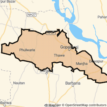
Gopalganj District Map
Current Corona Virus Infected Patients Count in Gopalganj District
| City Name | District Name | Total Covid cases |
|---|
Gopalganj Live Weather
Temperature: 17.1 °C
clear sky
Humidity: 40%
Wind : 1.97 mt/sec towards W
StationName : "GopÄ\u0081lganj"
observed on 57 Mins Back
Temperature: 17.1 °C
clear sky
Humidity: 40%
Wind : 1.97 mt/sec towards W
StationName : "GopÄ\u0081lganj"
observed on 57 Mins Back
Gopalganj Weather Forecast for Next 5 days
02-01-2026
13.1°C to 17.3°C
clear sky
13.1°C to 17.3°C
clear sky
03-01-2026
12.1°C to 23.1°C
clear sky
12.1°C to 23.1°C
clear sky
04-01-2026
12.5°C to 23.5°C
clear sky
12.5°C to 23.5°C
clear sky
05-01-2026
12.4°C to 23.2°C
clear sky
12.4°C to 23.2°C
clear sky
06-01-2026
11.8°C to 23.1°C
clear sky
11.8°C to 23.1°C
clear sky
Temples in Gopalganj
The Durga Temple
The Durga Temple
Historical Daily Max Temperatures (Next 7 Days)
| Years | 01 Jan | 02 Jan | 03 Jan | 04 Jan | 05 Jan | 06 Jan | 07 Jan |
|---|---|---|---|---|---|---|---|
| 2025 | |||||||
| 2024 | |||||||
| 2023 |
About Gopalganj District
Gopalganj District is one among 38 Districts of Bihar State ,India. Gopalganj District Administrative head quarter is Gopalganj. It is is Located 135 KM South towards State capital Patna . Gopalganj District population is 2558037. It is 21 st Largest District in the State by population.Geography and Climate Gopalganj District
It is Located at Latitude-26.4, Longitude-84.4. Gopalganj District is sharing border with Purbi Champaran District to the East , Siwan District to the South , Deoria District to the west . It is sharing Border with Uttar Pradesh State to the west . Gopalganj District occupies an area of approximately 2033 square kilometres. . Its in the 72 meters to 65 meters elevation range.This District belongs to Hindi Belt India .DemoGraphics of Gopalganj District
Maithili is the Local Language here. Also People Speaks Bhojpuri, Hindi, Urdu . Gopalganj District is divided into 14 Blocks , 227 Panchayats , 533 Villages. Panchdeori Block is the Smallest Block by population with 83826 population. Kuchaikote Block is the Biggest Block by population with 277714 population.Major producing Items,Crops,Industries and Exports from Gopalganj District
Basket, Blanket, Booket, Bricks, Cloth, EarthenPot, Earthenware, Fertilizer, Furture, Gur, MatchBox, MustardOil, Pot, Rope, Sugar, Tobacco, Treacle, WoodenFurture are the major producing Items and Exports from here.Census 2011 of Gopalganj District
Gopalganj district Total population is 2558037 according to census 2011.Males are 1269497 and Females are 1288540 .Literate people are 1692397 among total.Its total area is 2033 sq.km. It is the 21 st largest district in the state by Population . But 27 th Largest District in the state By Area. 162 nd Largest District in the Country By Population. 13 th highest District in the State By literacy rate. 452 nd highest District in the Country By literacy rate.its literacy Rate is 67.04Politics in Gopalganj District
JD(U) , LJP , BJP , Janata Dal (United) , RJD , HAM(S) are the major political parties in Gopalganj District.Assembly constituencies in Gopalganj District
Total 6 Assembly constituencies in Gopalganj District.| Constituency name | MLA name | Party |
|---|---|---|
| Barauli | Rampravesh Rai | BJP |
| Gopalganj | Subash Singh | BJP |
| Kuchaikote | Amrendra Kumar Pandey | JD(U) |
| Bhore | Sunil Kumar | BJP |
| Hathua | Rajesh Kumar Singh | JD(U) |
| Baikunthpur | Prem Shankar Prasad | JD(U) |
Parliament constituencies in Gopalganj District
Total 1 Parliament constituencies in Gopalganj District.| Constituency name | MP name | Party |
|---|---|---|
| Gopalganj | DR. ALOK KUMAR SUMAN | Janata Dal (United) |
Gopalganj District Political Map
Gopalganj Commerce
Total Registered Comapnies with Ministry of Corporate Affairs (MCA) in Gopalganj are 203Company Name : SONA SATI ORGANICS PRIVATE LIMITED
Type Of Business : OTHERS
Capital : 4.2537 Crores
Company Name : SONA ENGICON PRIVATE LIMITED
Type Of Business : OTHERS
Capital : 2.4873 Crores
Company Name : HARIOM FEEDS PRIVATE LIMITED
Type Of Business : Agriculture and Allied Activities
Capital : 2.08 Crores
Company Name : MAA AMBE AGROTECH PRIVATE LIMITED
Type Of Business : Transport, storage and Communications
Capital : 1.8403 Crores
More Gopalganj Registered Companies
Gopalganj District Tourism
Temples in Gopalganj District
The Durga Temple are the famous temple in Gopalganj DistrictGopalganj Transport
Road Transport
District Headquarters Gopalganj is well connected by road . Mirganj , Barauli , Gopalganj are the Cities in this district having road connectivity to major towns and remote villages. Gopalganj is about 135 KM by road to Patna( Capital of Bihar )Rail Transport
Some of the rail way stations in district are Thawe Junction , Hathua Junction , Brij Kishore Halt , Gopalganj , Jalalpur , Sasa Musa , Sipaya , Sidhwalia .... which connects most of the towns and villages in the District.Bus Transport
Bihar State Road Transportation Corporation ( BSTDC) runs Busses from Major cities to Towns and Villages in this District.
Pin Codes in Gopalganj District
841413
( Jamobazar ) ,
841405
( Barauli (Gopalganj)) ,
841420
( Rajapatti ) ,
841503
( Nechwajalapur ) ,
841436
( Hathwa ) ,
841501
( Kuchaikote ) ,
841437
( Kateya ) ,
841407
( Bishunpura ) ,
841438
( Mirganj ) ,
841409
( Dighwdubauli ) ,
841426
( Bhore ) ,
841505
( Sasamusa ) ,
841441
( Baghibazar ) ,
841427
( Garhmanjha ) ,
841428
( Gopalganj ) ,
841423
( Sidhwalia ) ,
841440
( Thawe ) ,
841508
( Bijaipur (Gopalganj)) ,
841425
( Bathubazar ) ,
more PinCodes
Hotels in Gopalganj
BusStops in Gopalganj Lakes in Gopalganj Temples in Gopalganj Shops in Gopalganj Gopalganj Hospitals Hotel/Restaurants in Gopalganj Gopalganj RailwayStations Gopalganj BusStops ATM in Gopalganj
Near Cities
Gopalganj 1 KM near
Mirganj 17 KM near
Barauli 17 KM near
Areraj 26 KM near
Near By Air Ports
Gorakhpur Airport 118 KM near
Patna Airport 128 KM near
Varanasi Airport 219 KM near
Gaya Airport 220 KM near
Near By Districts
Gopalganj 0 KM near
Siwan 32 KM near
Pashchim Champaran 43 KM near
Purbi Champaran 53 KM near