| Home | City Bus | Maps | Villages | Cities | Rail | Tourist Places | School | College | Pin Codes | Corona Cases Count |
| Distance Calculator Bus Services IFSC Codes Trace Mobile Number Weather Search Place Trace IP Available Cash ATM/Banks Locate Polling Booth Report an Error contact People |
Head Quarters : Dimapur
Language : English
Area: 927 sq. km
Population : 379769
Sex Ratio : 916
Density : 410/ sq. km
Literacy : 85.44
Elevation / Altitude: 170 - 154 meters. Above Seal level
Current Time 04:49 AM
Date: Thursday , Jan 08,2026 (IST)
Time zone: IST (UTC+5:30)
District Pin code Index: 797XXX
Vehicle Registration Number: NL-07
RTO Office: Dimapur
Tourist Places near Dimapur
Diphu Kohima (Kohima) Wokha (Wokha) Golaghat Phek (Phek) Kaziranga National Park
Diphu Kohima (Kohima) Wokha (Wokha) Golaghat Phek (Phek) Kaziranga National Park
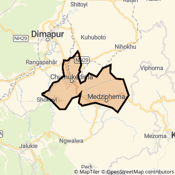
Dimapur District Map
Current Corona Virus Infected Patients Count in Dimapur District
| City Name | District Name | Total Covid cases |
|---|
Dimapur Live Weather
Temperature: 10.6 °C
clear sky
Humidity: 87%
Wind : 0.35 mt/sec towards SW
StationName : "DimÄ\u0081pur"
observed on 2 Hours Back
Temperature: 10.6 °C
clear sky
Humidity: 87%
Wind : 0.35 mt/sec towards SW
StationName : "DimÄ\u0081pur"
observed on 2 Hours Back
Dimapur Weather Forecast for Next 5 days
08-01-2026
10.6°C to 10.6°C
clear sky
10.6°C to 10.6°C
clear sky
09-01-2026
9.9°C to 24.6°C
clear sky
9.9°C to 24.6°C
clear sky
10-01-2026
10.2°C to 25.7°C
clear sky, scattered clouds
10.2°C to 25.7°C
clear sky, scattered clouds
11-01-2026
10.5°C to 25.8°C
few clouds, broken clouds, clear sky
10.5°C to 25.8°C
few clouds, broken clouds, clear sky
12-01-2026
10.4°C to 25.5°C
clear sky
10.4°C to 25.5°C
clear sky
Temples in Dimapur
Historical Daily Min/Max Temperatures (Next 7 Days)
| Years | 07 Jan | 08 Jan | 09 Jan | 10 Jan | 11 Jan | 12 Jan | 13 Jan |
|---|---|---|---|---|---|---|---|
| 2025 | 26.0°C/ 11.0°C | 26.0°C/ 12.0°C | 28.0°C/ 12.0°C | ||||
| 2024 | 24.0°C/ 11.0°C | 23.0°C/ 11.0°C | 22.0°C/ 11.0°C | 23.0°C/ 12.0°C | |||
| 2023 | 23.0°C/ 12.0°C | 25.0°C/ 12.0°C | 25.0°C/ 12.0°C | 25.0°C/ 12.0°C |
About Dimapur District
Dimapur District is one among 11 Districts of Nagaland State ,India. Dimapur District Administrative head quarter is Dimapur. It is is Located 52 KM East towards State capital Kohima . Dimapur District population is 379769. It is Biggest district in Nagaland State by population.Geography and Climate Dimapur District
It is Located at Latitude-25.8, Longitude-93.7. Dimapur District is sharing border with Peren District to the South . It is sharing Border with Meghalaya State to the west . Dimapur District occupies an area of approximately 927 square kilometres. . Its in the 170 meters to 154 meters elevation range.This District belongs to Eastern India .DemoGraphics of Dimapur District
English is the Local Language here. Dimapur District is divided into 5 Tehsils , 255 Panchayats , 275 Villages. Kuhuboto Tehsil is the Smallest Tehsil by population with 12699 population. Dimapur Tehsil is the Biggest Tehsil by population with 127458 population.Census 2011 of Dimapur District
Dimapur district Total population is 379769 according to census 2011.Males are 198209 and Females are 181560 .Literate people are 251255 among total.Its total area is 927 sq.km. It is the 1 st largest district in the state by Population . But 5 th Largest District in the state By Area. 553 rd Largest District in the Country By Population. 3 rd highest District in the State By literacy rate. 70 th highest District in the Country By literacy rate.its literacy Rate is 85.44Assembly constituencies in Dimapur District
Parliament constituencies in Dimapur District
Dimapur District Political Map
Dimapur Commerce
Total Registered Comapnies with Ministry of Corporate Affairs (MCA) in Dimapur are 274Company Name : NAGALAND INDUSTRIAL DEVELOPMENT CORPORATION LIMITED
Type Of Business : Community, personal & Social Services
Capital : 18.9502 Crores
Company Name : SHYAMA POWER INDIA LIMITED
Type Of Business : Construction
Capital : 15.0761 Crores
Company Name : AADYASHAKTI FOODS & BEVERAGES PRIVATE LIMITED
Type Of Business : Manufacturing (Food stuffs)
Capital : 9.913 Crores
Company Name : DOYS AGRI RESOURCES PRIVATE LIMITED
Type Of Business : Community, personal & Social Services
Capital : 8.73 Crores
More Dimapur Registered Companies
Dimapur District Tourism
Diphu , are the Tourist destinations to Visit.
Dimapur Transport
Road Transport
District Headquarters Dimapur is well connected by road . Dimapur , Diphu are the Cities in this district having road connectivity to major towns and remote villages. Dimapur is about 52 KM by road to Kohima( Capital of Nagaland )Rail Transport
Some of the rail way stations in district are Lumding Junction , Dimapur , Diphu , Bokajan , Dhansiri , Barlangfer , Khotkhoti , Nailalung .... which connects most of the towns and villages in the District.Bus Transport
Pin Codes in Dimapur District
797113
( New Nepaligaon ) ,
797117
( Circular Road ) ,
797116
( Dimapur Bazar ) ,
797112
( Dimapur ) ,
797115
( Artc ) ,
797103
( Chumukedima ) ,
797106
( Medziphema ) ,
more PinCodes
Hotels in Dimapur
Saramati Hotel
Near Super Market, Dimapur - 797112, India
Dimapur
Contact No: 03862 - 234761
Price Range : Rs. 1200 - Rs. 6000
Hotel De Oriental Dream
Bank Colony; Opp.Naga Shopping Arcade; Kohima rd; Dimapur; Nagaland; Pin code- 797112
Dimapur
Price Range : Rs. 1600 - Rs. 2500
Hotel Maple
Near Hongkong Market; Opposite Jack & Jill; Dimapur; Nagaland; Pin code- 797112
Dimapur
Price Range : Rs. 400 - Rs. 400
Hotel Tragopan
Circular Road Dimapur - 797112, India
Dimapur
Contact No: 0386 - 2230351, 2230291, 2232951, 2225537
Price Range : Rs. 1600 - Rs. 2100
Near Cities
Dimapur 2 KM near
Diphu 33 KM near
Kohima 50 KM near
Lumding 65 KM near
Near By Air Ports
Dimapur Airport 4 KM near
Rowriah Airport 116 KM near
Imphal Municipal Airport 141 KM near
Salonibari Airport 146 KM near
Near By Districts
Dimapur 0 KM near
Peren 47 KM near
Kohima 51 KM near
Wokha 63 KM near