| Home | City Bus | Maps | Villages | Cities | Rail | Tourist Places | School | College | Pin Codes | Corona Cases Count |
| Distance Calculator Bus Services IFSC Codes Trace Mobile Number Weather Search Place Trace IP Available Cash ATM/Banks Locate Polling Booth Report an Error contact People |
Anantapur District.
Currently In:
India >>
Andhra Pradesh
Region : Rayalaseema
Head Quarters : Anantapur
Language : Telugu and Urdu
Area: 19130 sq. km
Population : 4083315
Sex Ratio : 977
Density : 213/ sq. km
Literacy : 64.28
Elevation / Altitude: 800 - 223 meters. Above Seal level
Current Time 05:53 AM
Date: Saturday , Jan 03,2026 (IST)
Time zone: IST (UTC+5:30)
District Pin code Index: 515XXX
Vehicle Registration Number: AP-02
RTO Office: Anantapur,Hindupur
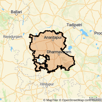
Anantapur District Map
Current Corona Virus Infected Patients Count in Anantapur District
| City Name | District Name | Total Covid cases |
|---|
Anantapur Live Weather
Temperature: 21.5 °C
overcast clouds
Humidity: 78%
Wind : 2.49 mt/sec towards SE
StationName : "Anantapur"
observed on 2 Hours Back
Temperature: 21.5 °C
overcast clouds
Humidity: 78%
Wind : 2.49 mt/sec towards SE
StationName : "Anantapur"
observed on 2 Hours Back
Anantapur Weather Forecast for Next 5 days
04-01-2026
20.6°C to 30.3°C
overcast clouds, broken clouds, few clouds, clear sky
20.6°C to 30.3°C
overcast clouds, broken clouds, few clouds, clear sky
05-01-2026
19.4°C to 30.0°C
broken clouds, scattered clouds, clear sky
19.4°C to 30.0°C
broken clouds, scattered clouds, clear sky
06-01-2026
19.1°C to 29.5°C
clear sky, broken clouds, scattered clouds
19.1°C to 29.5°C
clear sky, broken clouds, scattered clouds
07-01-2026
18.6°C to 28.3°C
overcast clouds, broken clouds, scattered clouds, few clouds
18.6°C to 28.3°C
overcast clouds, broken clouds, scattered clouds, few clouds
Temples in Anantapur
Lepakshi Sri Lakshmi Narasimha Swamy temple sri sri sri kasi visweshwara swamy temple Veerabhadra temple (Lepakshi) Sri Sathya Sai Baba Temple
Lepakshi Sri Lakshmi Narasimha Swamy temple sri sri sri kasi visweshwara swamy temple Veerabhadra temple (Lepakshi) Sri Sathya Sai Baba Temple
Historical Daily Max Temperatures (Next 7 Days)
| Years | 02 Jan | 03 Jan | 04 Jan | 05 Jan | 06 Jan | 07 Jan | 08 Jan |
|---|---|---|---|---|---|---|---|
| 2025 | |||||||
| 2024 | |||||||
| 2023 |
About Anantapur District
Anantapur District is one among 23 Districts of Andhra Pradesh State ,India. It belongs to Rayalaseema Region . Anantapur District Administrative head quarter is Anantapur. It is is Located 368 KM North towards State capital Hyderabad . Anantapur District population is 4083315. It is 7 th Largest District in the State by population.Geography and Climate Anantapur District
It is Located at Latitude-14.6, Longitude-77.5. Anantapur District is sharing border with Chittoor District to the South , Kurnool District to the North , Cuddapah District to the East , Bellary District to the west , Chikballapur District to the South , Chitradurga District to the west , Tumkur District to the South . It is sharing Border with Karnataka State to the west . Anantapur District occupies an area of approximately 19130 square kilometres. . Its in the 800 meters to 223 meters elevation range.This District belongs to Southern India .DemoGraphics of Anantapur District
Telugu is the Local Language here. Also People Speaks Urdu . Anantapur District is divided into 63 Mandals , 1046 Panchayats , 3175 Villages. Gandlapenta Mandal is the Smallest Mandal by population with 24118 population. Anantapur Mandal is the Biggest Mandal by population with 308228 population.Major producing Items,Crops,Industries and Exports from Anantapur District
., Baans, Bajra, BandageCloth, Beedies, Bheedies, BronzeStatues, Chillies, Corriander, CottonThread, Fibre, Flowers, GNut, GrateStones, Greenchillies, Groundnut, Handicrafts, HandloomSilks, Jaggery, J are the major producing Items and Exports from here.Census 2011 of Anantapur District
Anantapur district Total population is 4083315 according to census 2011.Males are 2065410 and Females are 2017905 .Literate people are 2701521 among total.Its total area is 19130 sq.km. It is the 7 th largest district in the state by Population . But 1 st Largest District in the state By Area. 52 nd Largest District in the Country By Population. 15 th highest District in the State By literacy rate. 502 nd highest District in the Country By literacy rate.its literacy Rate is 64.28Assembly constituencies in Anantapur District
Parliament constituencies in Anantapur District
Anantapur District Political Map
Anantapur Commerce
Total Registered Comapnies with Ministry of Corporate Affairs (MCA) in Anantapur are 634Company Name : GERDAU STEEL INDIA PRIVATE LIMITED
Type Of Business : Manufacturing (Metals & Chemicals, and products thereof)
Capital : 2374.09 Crores
Company Name : HYUNDAI STEEL ANANTAPUR PRIVATE LIMITED
Type Of Business : Manufacturing (Metals & Chemicals, and products thereof)
Capital : 96.9468 Crores
Company Name : SAISUDHIR ENERGY LIMITED
Type Of Business : Electricity, Gas & Water companies
Capital : 89.5353 Crores
Company Name : HYUNDAI DYMOS INDIA PRIVATE LIMITED
Type Of Business : Manufacturing (Machinery & Equipments)
Capital : 63.1202 Crores
More Anantapur Registered Companies
Anantapur District Tourism
This district is in High Altitude .Lepakshi , Puttaparthi , Srirama Temple , Durga Temple , Kurma Saila, Tortoise Shaped Hills , Veerabhadra Temple , Prasanthi Nilayam , Sri Sathya Sai Hill View Stadium , Sri Sathya Sai University , Spiritual Museum , Sri Sathya Sai Space Theatre , are the Tourist destinations to Visit.
Temples in Anantapur District
Lepakshi , Sri Lakshmi Narasimha Swamy temple , sri sri sri kasi visweshwara swamy temple , Veerabhadra temple (Lepakshi) , Sri Sathya Sai Baba Temple are the famous temple in Anantapur DistrictAnantapur Transport
Road Transport
District Headquarters Anantapur is well connected by road . Anantapur , Kadiri , Kalyandurg , Gooty , Hindupur , Dharmavaram , Rayadurg , Tadpatri , Uravakonda , Guntakal are the Cities in this district having road connectivity to major towns and remote villages. Anantapur is about 368 KM by road to Hyderabad( Capital of Andhra Pradesh )Rail Transport
Some of the rail way stations in district are Guntakal Junction , Dharmavaram Junction , Gooty Junction , Anantapur , Hindupur , Tadipatri , Sri Sathya Sai Prashanthi Nilayam , Penukonda Junction .... which connects most of the towns and villages in the District.Bus Transport
Andhra Pradesh State Transport Corporation ( APSRTC) runs Busses from Major cities to Towns and Villages in this District.Anantapur APSRTC Bus Station , S.K. University APSRTC Bus Station , Bellary APSRTC Bus Station are the Bus Stations in Anantapur District .APSRTC runs Number of busses from major cities to here.
Pin Codes in Anantapur District
515751
( Atmakur(ATP) ) ,
515867
( Udegolam ) ,
515411
( Tadpatri ) ,
515842
( Konakondla ) ,
515154
( Pamudurthi ) ,
515863
( Gummaghatta ) ,
515872
( Herial ) ,
515611
( Tarimala ) ,
515766
( Kundurpi ) ,
515004
( Ramnagar (Ananthapur)) ,
515870
( Vidapanakal ) ,
515001
( Anantapur ) ,
515124
( Peddamanthur ) ,
515122
( Somandepalli ) ,
515521
( Gandlapenta ) ,
515003
( Sri Venkateswara Puram ) ,
515123
( Roddam ) ,
515435
( Singanamala ) ,
515445
( Ammaladinne ) ,
515672
( Dharmavaram R.S ) ,
more PinCodes
Hotels in Anantapur
SRS Regency Hotel
Kamalanagar, , Near Satyam City Scan Anantapur - 515001, India
Anantapur
Contact No: 08554 - 227777
Price Range : Rs. 600 - Rs. 900
Sampoorna Hotel
15-442, , kamalanagar Anantapur - 515001, India
Anantapur
Contact No: 08554 - 221852/3/4/6/7/8
Price Range : Rs. 400 - Rs. 800
Bheema Hotel
R. F. Road Anantapur - 515001, India
Anantapur
Contact No: 08554 - 221531-34
Price Range : Rs. 400 - Rs. 1000
Annapurna Hotel
Raju rd;Kamala Nagar; Anantapur; Andhra Pradesh; Pin code- 515001
Anantapur
Price Range : Rs. 200 - Rs. 600
BusStops in Anantapur Lakes in Anantapur Temples in Anantapur Shops in Anantapur Anantapur Hospitals Hotel/Restaurants in Anantapur Anantapur RailwayStations Anantapur BusStops ATM in Anantapur
Top 5 Engineering Colleges in Anantapur
Near Cities
Anantapur 3 KM near
Dharmavaram 37 KM near
Uravakonda 52 KM near
Gooty 55 KM near
Near By Air Ports
Bengaluru International Airport 184 KM near
Tirupati Airport 269 KM near
Hubli Airport 312 KM near
Mysore Airport 317 KM near
Near By Districts
Anantapur 0 KM near
Bellary 99 KM near
Cuddapah 151 KM near
Kurnool 151 KM near