| Home | City Bus | Maps | Villages | Cities | Rail | Tourist Places | School | College | Pin Codes | Corona Cases Count |
| Distance Calculator Bus Services IFSC Codes Trace Mobile Number Weather Search Place Trace IP Available Cash ATM/Banks Locate Polling Booth Report an Error contact People |
Amravati District.
Currently In:
India >>
Maharashtra
Region : Vidarbha
Division : Amravati
Head Quarters : Amravati
Language : English and Hindi, Marathi,
Area: 12235 sq. km
Population : 2887826
Sex Ratio : 947
Density : 237/ sq. km
Literacy : 88.23
Elevation / Altitude: 411 - 285 meters. Above Seal level
Current Time 12:49 PM
Date: Thursday , Jan 01,2026 (IST)
Time zone: IST (UTC+5:30)
District Pin code Index: 431XXX,444XXX
Vehicle Registration Number: MH-27
RTO Office: Amravati
Tourist Places near Amravati
Amravati Chikhaldara Wildlife Sanctuary Melghat Tiger Reserve Sevagram Washim Nagpur
Amravati Chikhaldara Wildlife Sanctuary Melghat Tiger Reserve Sevagram Washim Nagpur
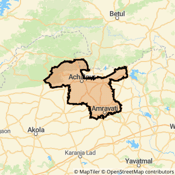
Amravati District Map
Current Corona Virus Infected Patients Count in Amravati District
| City Name | District Name | Total Covid cases |
|---|---|---|
| Amravati District | Amravati | 3 |
Amravati Live Weather
Temperature: 25.8 °C
clear sky
Humidity: 25%
Wind : 1.68 mt/sec towards SE
StationName : "Amravati"
observed on 37 Mins Back
Temperature: 25.8 °C
clear sky
Humidity: 25%
Wind : 1.68 mt/sec towards SE
StationName : "Amravati"
observed on 37 Mins Back
Amravati Weather Forecast for Next 5 days
02-01-2026
17.6°C to 27.4°C
clear sky
17.6°C to 27.4°C
clear sky
03-01-2026
16.6°C to 28.0°C
clear sky
16.6°C to 28.0°C
clear sky
04-01-2026
17.4°C to 28.1°C
clear sky
17.4°C to 28.1°C
clear sky
05-01-2026
17.3°C to 28.4°C
clear sky
17.3°C to 28.4°C
clear sky
06-01-2026
16.6°C to 28.1°C
clear sky
16.6°C to 28.1°C
clear sky
Temples in Amravati
Amba Devi Amravati
Amba Devi Amravati
Historical Daily Max Temperatures (Next 7 Days)
| Years | 01 Jan | 02 Jan | 03 Jan | 04 Jan | 05 Jan | 06 Jan | 07 Jan |
|---|---|---|---|---|---|---|---|
| 2025 | |||||||
| 2024 | |||||||
| 2023 |
About Amravati District
Amravati District is one among 34 Districts of Maharashtra State ,India. It belongs to Vidarbha Region . Amravati District Administrative head quarter is Amravati. It is is Located 648 KM west towards State capital Mumbai . Amravati District population is 2887826. It is 13 th Largest District in the State by population.Geography and Climate Amravati District
It is Located at Latitude-20.9, Longitude-77.7. Amravati District is sharing border with Betul District to the North , East Nimar District to the west , Akola District to the west , Wardha District to the East , Yavatmal District to the South . It is sharing Border with Madhya Pradesh State to the North . Amravati District occupies an area of approximately 12235 square kilometres. . Its in the 411 meters to 285 meters elevation range.This District belongs to Western India .DemoGraphics of Amravati District
English is the Local Language here. Also People Speaks Hindi, Marathi, . Amravati District is divided into 14 Talukas , 805 Panchayats , 1712 Villages. Chandur Ril Taluka is the Smallest Taluka by population with 90645 population. Amravati Taluka is the Biggest Taluka by population with 678192 population.Major producing Items,Crops,Industries and Exports from Amravati District
Masala are the major producing Items and Exports from here.Census 2011 of Amravati District
Amravati district Total population is 2887826 according to census 2011.Males are 1483218 and Females are 1404608 .Literate people are 1910586 among total.Its total area is 12235 sq.km. It is the 13 th largest district in the state by Population . But 7 th Largest District in the state By Area. 130 th Largest District in the Country By Population. 3 rd highest District in the State By literacy rate. 38 th highest District in the Country By literacy rate.its literacy Rate is 88.23Politics in Amravati District
Independent , Bharatiya Janata Party , PJP , BJP , NCP , MSP , SHS , INC are the major political parties in Amravati District.Assembly constituencies in Amravati District
Total 8 Assembly constituencies in Amravati District.| Constituency name | MLA name | Party |
|---|---|---|
| Dhamangaon Railway | Adsad Pratap Arunbhau | BJP |
| Badnera | Ravi Rana | IND |
| Amravati | Sulbha Sanjay Khodke | INC |
| Teosa | Yashomati Chandrakant Thakur | INC |
| Daryapur | Balwant Baswant Wankhade | INC |
| Melghat | Rajkumar Dayaram Patel | PJP |
Parliament constituencies in Amravati District
Total 2 Parliament constituencies in Amravati District.| Constituency name | MP name | Party |
|---|---|---|
| Amravati | Navnit Ravi Rana | Independent |
| Wardha | Ramdas Chandrabhanji Tadas | Bharatiya Janata Party |
Amravati District Political Map
Amravati Commerce
Total Registered Comapnies with Ministry of Corporate Affairs (MCA) in Amravati are 884Company Name : DEEGEE COTSYN PRIVATE LIMITED
Type Of Business : Manufacturing (Textiles)
Capital : 30.72 Crores
Company Name : JADHAO GEARS LIMITED
Type Of Business : Manufacturing (Machinery & Equipments)
Capital : 13.725 Crores
Company Name : DEEGEE ORCHARDS PRIVATE LIMITED.
Type Of Business : Agriculture and Allied Activities
Capital : 10.0 Crores
Company Name : JADHAO GEARS PRIVATE LIMITED
Type Of Business : Manufacturing (Machinery & Equipments)
Capital : 9.15 Crores
More Amravati Registered Companies
Amravati District Tourism
Amravati , Melghat Tiger Reserve , Sai Temple , Shree Swami Samarth Temple , Ambadevi Temple , Ekvira Devi Temple , are the Tourist destinations to Visit.
Temples in Amravati District
Amba Devi Amravati are the famous temple in Amravati DistrictAmravati Transport
Road Transport
District Headquarters Amravati is well connected by road . Amravati , Morshi , Shendurjana , Warud , Achalpur are the Cities in this district having road connectivity to major towns and remote villages. Amravati is about 648 KM by road to Mumbai( Capital of Maharashtra )Rail Transport
Some of the rail way stations in district are Badnera Junction , Dhamangaon , Amravati , Chandur , Kuram , Malkhed , Talni , Timtala .... which connects most of the towns and villages in the District.Bus Transport
Maharashtra State Road Transportation ( MSRTC) runs Busses from Major cities to Towns and Villages in this District.
Pin Codes in Amravati District
444702
( Dharni ) ,
444903
( Tiosa ) ,
444806
( Achalpur City ) ,
444809
( Karajgaon ) ,
444805
( Paratwada ) ,
444717
( Dhamangaon Gadhi ) ,
444720
( Brahmanwada Thadi ) ,
444711
( Mangrul Dastgir ) ,
444601
( Amravati ) ,
444604
( V.M.V. (Amravati) ) ,
444705
( Anjangaon ) ,
444605
( Rajapeth ) ,
444808
( Pathrot ) ,
444804
( Purna Nagar ) ,
444606
( Rukhmini Nagar ) ,
444704
( Chandur Bazar ) ,
444907
( Shendurjana Ghat ) ,
444803
( Daryapur Town ) ,
444707
( Nerpingalai ) ,
444602
( Sant GadgebabaAmravatiUniversity) ,
more PinCodes
Hotels in Amravati
Tourist Hotel
Maltekdi Road, Near Railway Station, Amravati - 444601, India
Amravati
Contact No: 0721 - 677088
Price Range : Rs. 400 - Rs. 400
Samrat Hotel
Jawahar Road, Amravati - 444601, India
Amravati
Contact No: 0721 - 2678370
Price Range : Rs. 600 - Rs. 900
Hindustan International Hotel
Satidham Complex, Near Chitra Talkies Amravati - 444601, India
Amravati
Contact No: 0721-2575375, 2579012, 2670209
Email: info@hotelhindustaninternational.net
Price Range : Rs. 800 - Rs. 1900
Harshawardhan Hotel
Opposite ITI Institute, Chikhaldara H O, Chikhaldara - 444807
Chikhaldara
Contact No: 91)-(7220)-230502
Price Range : Rs. 1600 - Rs. 2300
BusStops in Amravati Lakes in Amravati Temples in Amravati Shops in Amravati Amravati Hospitals Hotel/Restaurants in Amravati Amravati RailwayStations Amravati BusStops ATM in Amravati
Near Cities
Amravati 2 KM near
Murtijapur 49 KM near
Achalpur 51 KM near
Morshi 60 KM near
Near By Air Ports
Sonegaon Airport 152 KM near
Nanded Airport 222 KM near
Bhopal Airport 298 KM near
Chikkalthana Airport 305 KM near
Near By Districts
Amravati 0 KM near
Yavatmal 77 KM near
Akola 93 KM near
Wardha 101 KM near