| Home | City Bus | Maps | Villages | Cities | Rail | Tourist Places | School | College | Pin Codes | Corona Cases Count |
| Distance Calculator Bus Services IFSC Codes Trace Mobile Number Weather Search Place Trace IP Available Cash ATM/Banks Locate Polling Booth Report an Error contact People |
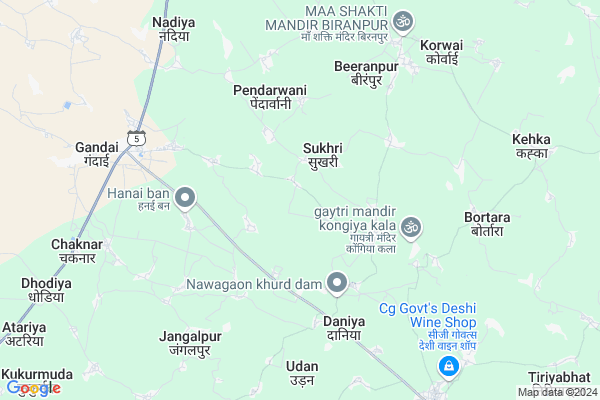
Bagur
Bagur Map
EDIT Map
Add Your House
 ..
..
Current Corona Virus Infected Patients Count in Rajnandgaon District
| City Name | District Name | Total Covid cases |
|---|---|---|
| Rajnandgaon | Rajnandgaon | 1 |
Locality Name :
Bagur
( बगुर )
Tehsil Name : Chhuikhadan
District : Rajnandgaon
State : Chattisgarh
Language : Chhattisgarhi and Hindi
Current Time 06:31 AM
Date: Saturday , May 03,2025 (IST)
Time zone: IST (UTC+5:30)
Elevation / Altitude: 319 meters. Above Seal level
Telephone Code / Std Code: 07743
Assembly constituency : Khairagarh assembly constituency
Assembly MLA : Yashoda Nilamber Verma
Lok Sabha constituency : Rajnandgaon parliamentary constituency
Parliament MP : SANTOSH PANDEY
Serpanch Name :
Pin Code : 491888
Post Office Name : Gandai Pandaria
Main Village Name : Bagur
Commodities Prices : Gandai Market / Mandi
Bagur Live Weather
Temperature: 28.6 °C
clear sky
Humidity: 48%
Wind : 2.06 mt/sec towards SW
StationName : "Gandai"
observed on Now
Temperature: 28.6 °C
clear sky
Humidity: 48%
Wind : 2.06 mt/sec towards SW
StationName : "Gandai"
observed on Now
Bagur Weather Forecast for Next 5 days
04-05-2025
26.6°C to 40.4°C
light rain, clear sky, broken clouds, scattered clouds, few clouds
26.6°C to 40.4°C
light rain, clear sky, broken clouds, scattered clouds, few clouds
05-05-2025
27.8°C to 40.8°C
scattered clouds, clear sky, light rain, broken clouds
27.8°C to 40.8°C
scattered clouds, clear sky, light rain, broken clouds
06-05-2025
27.5°C to 41.9°C
scattered clouds, clear sky, broken clouds
27.5°C to 41.9°C
scattered clouds, clear sky, broken clouds
07-05-2025
28.0°C to 42.0°C
broken clouds, clear sky, few clouds, scattered clouds
28.0°C to 42.0°C
broken clouds, clear sky, few clouds, scattered clouds
08-05-2025
29.0°C to 42.0°C
scattered clouds, broken clouds, overcast clouds
29.0°C to 42.0°C
scattered clouds, broken clouds, overcast clouds
Rivers Near Bagur
Shivnath :Seonath
Tanda
Shivnath :Seonath
Tanda
About Bagur
Correct below Info and add more info about BagurBagur is a small Village/hamlet in Chhuikhadan Tehsil in Rajnandgaon District of Chattisgarh State, India. It comes under Bagur Panchayath. It is located 74 KM towards North from District head quarters Rajnandgaon. 20 KM from Chhuikhadan. 77 KM from State capital Raipur
Bagur Pin code is 491888 and postal head office is Gandai Pandaria .
Patharra ( 3 KM ) , Hanaiban ( 4 KM ) , Garra ( 4 KM ) , Pendarwani ( 4 KM ) , Bhurbhusi ( 5 KM ) are the nearby Villages to Bagur. Bagur is surrounded by Chhuikhadan Tehsil towards west , S.Lohara Tehsil towards North , Khairagarh Tehsil towards South , Dhamdha Tehsil towards South .
Bemetra , Kawardha , Bhilai , Durg-Bhilai Nagar are the near by Cities to Bagur.
Bagur 2011 Census Details
Bagur Local Language is Chhattisgarhi. Bagur Village Total population is 965 and number of houses are 199. Female Population is 51.9%. Village literacy rate is 59.7% and the Female Literacy rate is 26.6%.
Population
| Census Parameter | Census Data |
| Total Population | 965 |
| Total No of Houses | 199 |
| Female Population % | 51.9 % ( 501) |
| Total Literacy rate % | 59.7 % ( 576) |
| Female Literacy rate | 26.6 % ( 257) |
| Scheduled Tribes Population % | 11.0 % ( 106) |
| Scheduled Caste Population % | 11.8 % ( 114) |
| Working Population % | 53.2 % |
| Child(0 -6) Population by 2011 | 146 |
| Girl Child(0 -6) Population % by 2011 | 52.7 % ( 77) |
Bagur Census More Deatils.
Politics in Bagur
Bharatiya Janata Party , BJP , INC are the major political parties in this area.Polling Stations /Booths near Bagur
1)Sooradabri2)Baghmara
3)Pasalkhaira
4)Dharia
5)Karamtara
HOW TO REACH Bagur
By Rail
There is no railway station near to Bagur in less than 10 km.Colleges near Bagur
Veerangana Avanti Bai Govt. College
Address : Chhuikhadan, Raipur
Schools in Bagur
M.s. (new) Bagur
Address : bagur , chuikhadan , rajnandgaon , Chattisgarh . PIN- 491888 , Post - Gandai Pandaria
Govt Health Centers near Bagur
1) SHC Dhodha , Sub Health Center Dhodha , ,2) SHC Barbaspur(RAJNDG) , Sub Health Center Barbaspur , ,
3) Pendarwani , Sub Health Center Pendarbani , ,
Sub Villages in Bagur
Hospitals in Bagur,Chhuikhadan
Heath Care Clinic
Main Chowk; Mall Godam Rd; Gandhi Nagar; Rampura Phul; Punjab 151103; India
7.5 KM distance Detail
more ..
Petrol Bunks in Bagur,Chhuikhadan
HP PETROL PUMP - MAA GANGAI FUELS
HP Petrol Pump Gandai Dhamdha Road Gandai; Raipur; Chhattisgarh 491888; India
7.0 KM distance Detail
more ..
Colleges in Bagur,Chhuikhadan
Late Shri Devi Prasad Ji Choubey Govt. College; Gandai
Gandai; Chhattisgarh 491888; India
7.7 KM distance Detail
AIIT GROUP OF INSTITUTIONS GANDAI
Pandariya Road; Gandai; Chhattisgarh 491888; India
8.1 KM distance Detail
more ..
Local Parks in Bagur,Chhuikhadan
About Bagur &
History
How to reach Bagur
Tourist Places Near By Bagur
Schools in Bagur
Colleges in Bagur
Temperature & weather of Bagur
places in Bagur
Bagur photos
More Information
How to reach Bagur
Tourist Places Near By Bagur
Schools in Bagur
Colleges in Bagur
Temperature & weather of Bagur
places in Bagur
Bagur photos
More Information
Village Talk
Post News or Events about this Village
Near Cities
Bemetra 43 KM near
Kawardha 45 KM near
Bhilai 59 KM near
Durg-Bhilai Nagar 62 KM near
Bemetra 43 KM near
Kawardha 45 KM near
Bhilai 59 KM near
Durg-Bhilai Nagar 62 KM near
Near By Taluks
Saja 18 KM near
Chhuikhadan 19 KM near
S.Lohara 19 KM near
Khairagarh 36 KM near
Saja 18 KM near
Chhuikhadan 19 KM near
S.Lohara 19 KM near
Khairagarh 36 KM near
Near By Air Ports
Raipur Airport 88 KM near
Jabalpur Airport 190 KM near
Sonegaon Airport 253 KM near
Khajuraho Airport 419 KM near
Raipur Airport 88 KM near
Jabalpur Airport 190 KM near
Sonegaon Airport 253 KM near
Khajuraho Airport 419 KM near
Near By Tourist Places
Kawardha 45 KM near
Durg 59 KM near
Bhilai 60 KM near
Rajnandgaon 70 KM near
Raipur 73 KM near
Kawardha 45 KM near
Durg 59 KM near
Bhilai 60 KM near
Rajnandgaon 70 KM near
Raipur 73 KM near
Near By Districts
Kabirdham 45 KM near
Durg 59 KM near
Rajnandgaon 70 KM near
Raipur 74 KM near
Kabirdham 45 KM near
Durg 59 KM near
Rajnandgaon 70 KM near
Raipur 74 KM near
Near By RailWay Station
Durg Junction Rail Way Station 58 KM near
Bhilai Power House Rail Way Station 60 KM near
Durg Junction Rail Way Station 58 KM near
Bhilai Power House Rail Way Station 60 KM near