| Home | City Bus | Maps | Villages | Cities | Rail | Tourist Places | School | College | Pin Codes | Corona Cases Count |
| Distance Calculator Bus Services IFSC Codes Trace Mobile Number Weather Search Place Trace IP Available Cash ATM/Banks Locate Polling Booth Report an Error contact People |
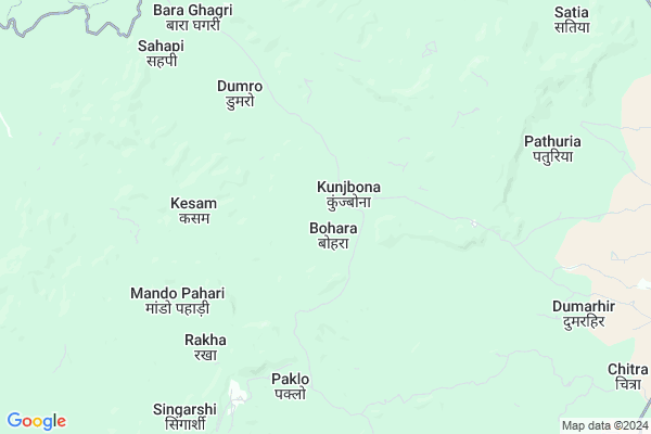
Bara Ejgo Map
EDIT Map
Add Your House
 ..
..
Current Corona Virus Infected Patients Count in Pakur District
| City Name | District Name | Total Covid cases |
|---|
Locality Name :
Bara Ejgo
( बारे ेजगो )
Block Name : Littipara
District : Pakur
State : Jharkhand
Language : Hindi and Santali
Current Time 10:20 PM
Date: Thursday , May 01,2025 (IST)
Time zone: IST (UTC+5:30)
Elevation / Altitude: 30 meters. Above Seal level
Telephone Code / Std Code: 06435
Assembly constituency : Litipara assembly constituency
Assembly MLA :
Lok Sabha constituency : Rajmahal parliamentary constituency
Parliament MP :
Serpanch Name :
Pin Code : 816104
Post Office Name : Hiranpur
Main Village Name : Bara Ejgo
Commodities Prices : Birbhum Market / Mandi
Bara Ejgo Live Weather
Temperature: 27.4 °C
overcast clouds
Humidity: 48%
Wind : 2.04 mt/sec towards S
StationName : "Godda"
observed on Now
Temperature: 27.4 °C
overcast clouds
Humidity: 48%
Wind : 2.04 mt/sec towards S
StationName : "Godda"
observed on Now
Bara Ejgo Weather Forecast for Next 5 days
02-05-2025
24.8°C to 25.7°C
overcast clouds, broken clouds
24.8°C to 25.7°C
overcast clouds, broken clouds
03-05-2025
23.5°C to 35.0°C
light rain, clear sky, overcast clouds, few clouds
23.5°C to 35.0°C
light rain, clear sky, overcast clouds, few clouds
04-05-2025
22.5°C to 36.4°C
broken clouds, few clouds, scattered clouds, light rain, moderate rain
22.5°C to 36.4°C
broken clouds, few clouds, scattered clouds, light rain, moderate rain
05-05-2025
22.3°C to 37.0°C
few clouds, clear sky, light rain, moderate rain, broken clouds
22.3°C to 37.0°C
few clouds, clear sky, light rain, moderate rain, broken clouds
06-05-2025
24.7°C to 36.6°C
clear sky, light rain, scattered clouds
24.7°C to 36.6°C
clear sky, light rain, scattered clouds
Rivers Near Bara Ejgo
Biharjor
Tribani
Biharjor
Tribani
About Bara Ejgo
Correct below Info and add more info about Bara EjgoBara Ejgo is a small Village/hamlet in Littipara Block in Pakur District of Jharkhand State, India. It comes under Bara Ejgo Panchayath. It is located 42 KM towards west from District head quarters Pakur. 8 KM from Littipara. 313 KM from State capital Ranchi
Bara Ejgo Pin code is 816104 and postal head office is Hiranpur .
Singarshi ( 8 KM ) , Dumarchir ( 14 KM ) are the nearby Villages to Bara Ejgo. Bara Ejgo is surrounded by Sunderpahari Block towards west , Amrapara Block towards South , Barhait Block towards North , Hiranpur Block towards East .
Godda , Pakaur , Dhulian , Dumka are the near by Cities to Bara Ejgo.
This Place is in the border of the Pakur District and Sahebganj District. Sahebganj District Pathna is East towards this place .
Bara Ejgo 2011 Census Details
Bara Ejgo Local Language is Hindi. Bara Ejgo Village Total population is 84 and number of houses are 16. Female Population is 53.6%. Village literacy rate is 29.8% and the Female Literacy rate is 15.5%.
Population
| Census Parameter | Census Data |
| Total Population | 84 |
| Total No of Houses | 16 |
| Female Population % | 53.6 % ( 45) |
| Total Literacy rate % | 29.8 % ( 25) |
| Female Literacy rate | 15.5 % ( 13) |
| Scheduled Tribes Population % | 100.0 % ( 84) |
| Scheduled Caste Population % | 0.0 % ( 0) |
| Working Population % | 50.0 % |
| Child(0 -6) Population by 2011 | 26 |
| Girl Child(0 -6) Population % by 2011 | 50.0 % ( 13) |
Bara Ejgo Census More Deatils.
Politics in Bara Ejgo
Jharkhand Mukti Morcha , BJP , JMM , INC are the major political parties in this area.Polling Stations /Booths near Bara Ejgo
1)Panchayat Bhawan Kamalghati W.part2)Community Hall Lakhanpur
3)Primary School Karanghati
4)Upgraded Middle School Kaldampahar
5)Primary School Margo
HOW TO REACH Bara Ejgo
By Rail
There is no railway station near to Bara Ejgo in less than 10 km.Schools near Bara Ejgo
Govt Health Centers near Bara Ejgo
1) HSC KUNJBONA , , ,2) HSC MAKRO , , ,
3) HSC DAMRULILATARI , , ,
Sub Villages in Bara Ejgo
Petrol Bunks in Bara Ejgo,Littipara
Susan Service Station Hindustan Petroleum
Hiranpur Khas; Pakur; Pakur Dumka Main Road; Hiranpur; Hiranpur; Jharkhand 816104; India
22.7 KM distance Detail
more ..
Schools in Bara Ejgo,Littipara
Kendriya Vidyalaya
Singarsi; No 507 Suaf; C/O 99 A P O; Bihar; C/O 99 A P O; Bihar 101633; India
9.2 KM distance Detail
Govt. Utkarmit High School Kariodih
Dumka; Main Rd; Kariodih; Hiranpur; Jharkhand 816104; India
21.2 KM distance Detail
Government High School Kariyodih
Kariyodih; Pakur; NH-114; Pakur Dumka Main Road Kariyodih; Hiranpur; Hiranpur; Jharkhand 816104; India
21.2 KM distance Detail
Local Parks in Bara Ejgo,Littipara
Governement Offices near Bara Ejgo,Littipara
About Bara Ejgo &
History
How to reach Bara Ejgo
Tourist Places Near By Bara Ejgo
Schools in Bara Ejgo
Colleges in Bara Ejgo
Temperature & weather of Bara Ejgo
places in Bara Ejgo
Bara Ejgo photos
More Information
How to reach Bara Ejgo
Tourist Places Near By Bara Ejgo
Schools in Bara Ejgo
Colleges in Bara Ejgo
Temperature & weather of Bara Ejgo
places in Bara Ejgo
Bara Ejgo photos
More Information
Village Talk
Post News or Events about this Village
Near Cities
Godda 35 KM near
Pakaur 40 KM near
Dhulian 53 KM near
Dumka 59 KM near
Godda 35 KM near
Pakaur 40 KM near
Dhulian 53 KM near
Dumka 59 KM near
Near By Taluks
Littipara 7 KM near
Sunderpahari 9 KM near
Amrapara 16 KM near
Barhait 25 KM near
Littipara 7 KM near
Sunderpahari 9 KM near
Amrapara 16 KM near
Barhait 25 KM near
Near By Air Ports
Bagdogra Airport 265 KM near
Netaji Subhas Chandra Bose Airport 276 KM near
Gaya Airport 289 KM near
Patna Airport 294 KM near
Bagdogra Airport 265 KM near
Netaji Subhas Chandra Bose Airport 276 KM near
Gaya Airport 289 KM near
Patna Airport 294 KM near
Near By Tourist Places
Pakur 40 KM near
Dumka 60 KM near
Sahibganj 70 KM near
Malda 82 KM near
English-Bazar 82 KM near
Pakur 40 KM near
Dumka 60 KM near
Sahibganj 70 KM near
Malda 82 KM near
English-Bazar 82 KM near
Near By Districts
Godda 36 KM near
Pakur 40 KM near
Dumka 60 KM near
Sahebganj 70 KM near
Godda 36 KM near
Pakur 40 KM near
Dumka 60 KM near
Sahebganj 70 KM near
Near By RailWay Station
Barharwa Junction Rail Way Station 37 KM near
Pakur Rail Way Station 40 KM near
Barharwa Junction Rail Way Station 37 KM near
Pakur Rail Way Station 40 KM near