| Home | City Bus | Maps | Villages | Cities | Rail | Tourist Places | School | College | Pin Codes | Corona Cases Count |
| Distance Calculator Bus Services IFSC Codes Trace Mobile Number Weather Search Place Trace IP Available Cash ATM/Banks Locate Polling Booth Report an Error contact People |
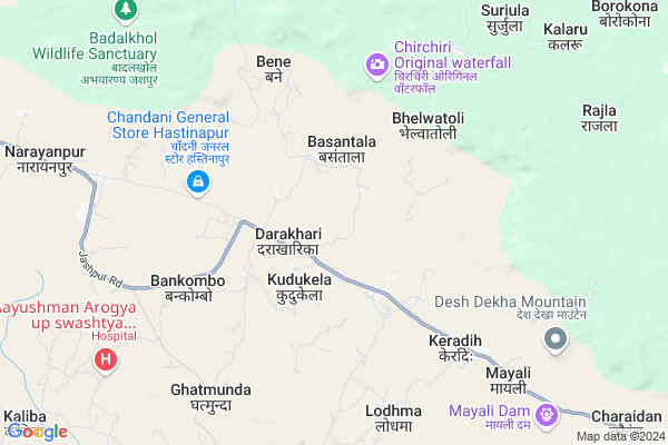
Chitak Wain
Chitak Wain Map
EDIT Map
Add Your House
 ..
..
Current Corona Virus Infected Patients Count in Jashpur District
| City Name | District Name | Total Covid cases |
|---|
Locality Name :
Chitak Wain
( छिटक वािण )
Tehsil Name : Kunkuri
District : Jashpur
State : Chattisgarh
Language : Chhattisgarhi and Hindi
Current Time 08:13 AM
Date: Saturday , May 03,2025 (IST)
Time zone: IST (UTC+5:30)
Elevation / Altitude: 619 meters. Above Seal level
Telephone Code / Std Code: 07764
Assembly constituency : Kunkuri assembly constituency
Assembly MLA : Vishnu Deo Sai
Lok Sabha constituency : Raigarh parliamentary constituency
Parliament MP : GOMATI SAI
Serpanch Name :
Pin Code : 496225
Post Office Name : Kunkuri
Main Village Name : Chitak Wain
Alternate Village Name : CHITAKWAIN
Commodities Prices : Kunkuri Market / Mandi
Chitak Wain Live Weather
Temperature: 27.7 °C
clear sky
Humidity: 46%
Wind : 1.54 mt/sec towards S
StationName : "Jashpurnagar"
observed on 45 Mins Back
Temperature: 27.7 °C
clear sky
Humidity: 46%
Wind : 1.54 mt/sec towards S
StationName : "Jashpurnagar"
observed on 45 Mins Back
Chitak Wain Weather Forecast for Next 5 days
04-05-2025
22.5°C to 34.2°C
clear sky, light rain, scattered clouds
22.5°C to 34.2°C
clear sky, light rain, scattered clouds
05-05-2025
21.8°C to 36.4°C
clear sky, scattered clouds, light rain, broken clouds
21.8°C to 36.4°C
clear sky, scattered clouds, light rain, broken clouds
06-05-2025
24.0°C to 39.2°C
scattered clouds, clear sky, broken clouds
24.0°C to 39.2°C
scattered clouds, clear sky, broken clouds
07-05-2025
26.2°C to 40.3°C
scattered clouds, clear sky, few clouds, light rain, overcast clouds
26.2°C to 40.3°C
scattered clouds, clear sky, few clouds, light rain, overcast clouds
08-05-2025
26.5°C to 40.1°C
broken clouds, light rain, scattered clouds
26.5°C to 40.1°C
broken clouds, light rain, scattered clouds
Rivers Near Chitak Wain
Girma
Bahri
Girma
Bahri
About Chitak Wain
Correct below Info and add more info about Chitak WainChitak Wain is a small Village/hamlet in Kunkuri Tehsil in Jashpur District of Chattisgarh State, India. It comes under Chitak Wain Panchayath. It is located 19 KM towards west from District head quarters Jashpur Nagar. 6 KM from Kunkuri. 350 KM from State capital Raipur
Chitak Wain Pin code is 496225 and postal head office is Kunkuri .
Kudukela ( 2 KM ) , Basantala ( 3 KM ) , Khutgaon ( 5 KM ) , Darakharika ( 5 KM ) , Kamtara ( 5 KM ) are the nearby Villages to Chitak Wain. Chitak Wain is surrounded by Manora Tehsil towards North , Duldula Tehsil towards South , Jashpur Tehsil towards East , Kansabel Tehsil towards South .
Jashpurnagar , Simdega , Gumla , Sundargarh are the near by Cities to Chitak Wain.
Chitakwain 2011 Census Details
Chitak Wain Local Language is Chhattisgarhi. Chitakwain Village Total population is 954 and number of houses are 230. Female Population is 46.3%. Village literacy rate is 64.5% and the Female Literacy rate is 24.7%.
Population
| Census Parameter | Census Data |
| Total Population | 954 |
| Total No of Houses | 230 |
| Female Population % | 46.3 % ( 442) |
| Total Literacy rate % | 64.5 % ( 615) |
| Female Literacy rate | 24.7 % ( 236) |
| Scheduled Tribes Population % | 35.2 % ( 336) |
| Scheduled Caste Population % | 16.4 % ( 156) |
| Working Population % | 67.1 % |
| Child(0 -6) Population by 2011 | 131 |
| Girl Child(0 -6) Population % by 2011 | 45.8 % ( 60) |
Chitakwain Census More Deatils.
Politics in Chitak Wain
Bharatiya Janata Party , BJP , INC are the major political parties in this area.Polling Stations /Booths near Chitak Wain
1)Narainpur2)Bokhi
3)Keradih
4)Kendapani
5)Basdevpur
HOW TO REACH Chitak Wain
By Rail
There is no railway station near to Chitak Wain in less than 10 km.Colleges near Chitak Wain
Government Girls College, Kansabel
Address : Church Road, Near High School
New Government College Kansabel
Address :
Govt. Vbsd Girls College Jashpur Nagar
Address : Major-priti Road, Basant Vihar, Jashpur
Schools in Chitak Wain
Govt. Ps. Chitakwain
Address : chitakwain , kunkuri , jashpur , Chattisgarh . PIN- 496225 , Post - Kunkuri
Govt Health Centers near Chitak Wain
1) SHC Bhelwantoli , SHC Bhelwantoli , Bhelwantoli , Bhelwantoli2) SHC Keradih , SHC Keradih , Keradih , Keradih
3) SHC Basantala , SHC Basantala , Basantala , Basantala
Sub Villages in Chitak Wain
Petrol Bunks in Chitak Wain,Kunkuri
Indian Oil Petrol Pump
Mahua Toli; Jashpur; NH-78; Ranchi Road; Kunkuri; Kunkuri; Chhattisgarh 496331; India
9.4 KM distance Detail
Kamla Fuel Center
Jashpur Nagar Hwy Marg; Khatanga; Chhattisgarh 496334; India
18.8 KM distance Detail
more ..
Colleges in Chitak Wain,Kunkuri
Government Industrial Training Institute Hostel
Saliatoli;; Chhattisgarh 496225; India
10.6 KM distance Detail
more ..
About Chitak Wain &
History
How to reach Chitak Wain
Tourist Places Near By Chitak Wain
Schools in Chitak Wain
Colleges in Chitak Wain
Temperature & weather of Chitak Wain
places in Chitak Wain
Chitak Wain photos
More Information
How to reach Chitak Wain
Tourist Places Near By Chitak Wain
Schools in Chitak Wain
Colleges in Chitak Wain
Temperature & weather of Chitak Wain
places in Chitak Wain
Chitak Wain photos
More Information
Village Talk
Post News or Events about this Village
Near Cities
Jashpurnagar 20 KM near
Simdega 65 KM near
Gumla 69 KM near
Sundargarh 89 KM near
Jashpurnagar 20 KM near
Simdega 65 KM near
Gumla 69 KM near
Sundargarh 89 KM near
Near By Taluks
Kunkuri 6 KM near
Manora 22 KM near
Duldula 23 KM near
Jashpur 27 KM near
Kunkuri 6 KM near
Manora 22 KM near
Duldula 23 KM near
Jashpur 27 KM near
Near By Air Ports
Ranchi Airport 164 KM near
Gaya Airport 261 KM near
Raipur Airport 330 KM near
Varanasi Airport 349 KM near
Ranchi Airport 164 KM near
Gaya Airport 261 KM near
Raipur Airport 330 KM near
Varanasi Airport 349 KM near
Near By Tourist Places
Jashpur 19 KM near
Simdega 66 KM near
Gumla 68 KM near
Netarhat 85 KM near
Ambikapur 96 KM near
Jashpur 19 KM near
Simdega 66 KM near
Gumla 68 KM near
Netarhat 85 KM near
Ambikapur 96 KM near
Near By Districts
Jashpur 18 KM near
Simdega 64 KM near
Gumla 69 KM near
Sundargarh 90 KM near
Jashpur 18 KM near
Simdega 64 KM near
Gumla 69 KM near
Sundargarh 90 KM near
Near By RailWay Station
Bamra Rail Way Station 104 KM near
Rajgangpur Rail Way Station 106 KM near
Bamra Rail Way Station 104 KM near
Rajgangpur Rail Way Station 106 KM near