| Home | City Bus | Maps | Villages | Cities | Rail | Tourist Places | School | College | Pin Codes | Corona Cases Count |
| Distance Calculator Bus Services IFSC Codes Trace Mobile Number Weather Search Place Trace IP Available Cash ATM/Banks Locate Polling Booth Report an Error contact People |
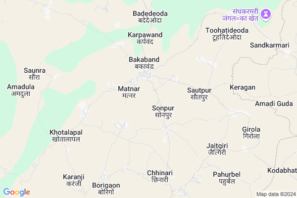
Narawand
Narawand Map
EDIT Map
Add Your House
 ..
..
Current Corona Virus Infected Patients Count in Bastar District
| City Name | District Name | Total Covid cases |
|---|
Locality Name :
Narawand
( नरवंद )
Tehsil Name : Bakawand
District : Bastar
State : Chattisgarh
Language : Oriya and Hindi
Current Time 06:15 AM
Date: Saturday , May 03,2025 (IST)
Time zone: IST (UTC+5:30)
Elevation / Altitude: 562 meters. Above Seal level
Telephone Code / Std Code: 07782
Assembly constituency : Bastar assembly constituency
Assembly MLA : Baghel Lakheshwar
Lok Sabha constituency : Bastar parliamentary constituency
Parliament MP : DEEPAK BAIJ
Serpanch Name :
Pin Code : 494222
Post Office Name : Bakawand
Main Village Name : Narawand
Commodities Prices : Karpawand Market / Mandi
Rivers Near Narawand
Indravati :Indravati River
Turi
Indravati :Indravati River
Turi
About Narawand
Correct below Info and add more info about NarawandNarawand is a small Village/hamlet in Bakawand Tehsil in Bastar District of Chattisgarh State, India. It comes under Narawand Panchayath. It is located 27 KM towards East from District head quarters Jagdalpur. 12 KM from Bakawand. 253 KM from State capital Raipur
Narawand Pin code is 494222 and postal head office is Bakawand .
Mangnar ( 3 KM ) , Chhinari ( 6 KM ) , Jaitgiri ( 7 KM ) , Satlawand ( 7 KM ) , Borigaon ( 8 KM ) are the nearby Villages to Narawand. Narawand is surrounded by Kosagumuda Tehsil towards East , Bastar Tehsil towards west , Dabugam Tehsil towards East , Jagdalpur Tehsil towards South .
Jagdalpur , Umarkote , Nabarangapur , Kondagaon are the near by Cities to Narawand.
Narawand 2011 Census Details
Narawand Local Language is Oriya. Narawand Village Total population is 652 and number of houses are 150. Female Population is 49.7%. Village literacy rate is 53.7% and the Female Literacy rate is 21.6%.
Population
| Census Parameter | Census Data |
| Total Population | 652 |
| Total No of Houses | 150 |
| Female Population % | 49.7 % ( 324) |
| Total Literacy rate % | 53.7 % ( 350) |
| Female Literacy rate | 21.6 % ( 141) |
| Scheduled Tribes Population % | 37.7 % ( 246) |
| Scheduled Caste Population % | 0.0 % ( 0) |
| Working Population % | 57.1 % |
| Child(0 -6) Population by 2011 | 79 |
| Girl Child(0 -6) Population % by 2011 | 46.8 % ( 37) |
Narawand Census More Deatils.
Politics in Narawand
Indian National Congress , BJP , INC are the major political parties in this area.Polling Stations /Booths near Narawand
1)Karanji2)Karmari
3)Karpavand 1
4)Tikara Lohanga 2
5)Baag Mohlai 2 (kosmaigudapara)
HOW TO REACH Narawand
By Rail
There is no railway station near to Narawand in less than 10 km.Colleges near Narawand
Govt College Bhanpuri Besoli
Address :
Bastar Medical College Of Alternative Medicines (bmcam)
Address :
Bastar College
Address :
Late Shri Baliram Kashyap Memorial Govt.medical College Jagdalpur
Address : Dimrapal Campus Jagdalpur Pin -494001
Higher Secondary School Gamhari
Address : Gamhari .kondagaon Road
Schools in Narawand
Ups Talsundipara
Address : narawand , bakawand , baster , Chattisgarh . PIN- 494221 , Post - Asna
Govt. Ms
Address : narawand , bakawand , baster , Chattisgarh . PIN- 494222 , Post - Bakawand
Govt Health Centers near Narawand
1) PHC Karpawand , PHC KARPAWAND , PANCHAYAT- KARPAWAND ,2) SHC Karpawand , SUB HEALTH CENTRE KARPAWAND , VILLAGE KARPAWAND PANCHAYAT- KARPAWAND ,
3) SHC Sonpur(BASTAR) , SUB HEALTH CENTRE SONPUR , VILLAGE SONPUR PANCHAYAT-SONPUR ,
Sub Villages in Narawand
Colleges in Narawand,Bakawand
Late Baliram Kashyap Govt. College Bakawand
Bakawand; Chhattisgarh 494222; India
12.6 KM distance Detail
more ..
Schools in Narawand,Bakawand
Saraswati Shishu Mandir High School Karpawand
Karpawand; Chhattisgarh 494222; India
1.9 KM distance Detail
Eklavya Model Residential School Karpawand
Karpawand; Chhattisgarh 494222; India
3.7 KM distance Detail
Electronic Shops in Narawand,Bakawand
Rajveer Electronics
Singsari - Karpawand Rd; Karpawand; Chhattisgarh 494222; India
2.2 KM distance Detail
R.K.Enterprises
Singsari - Karpawand Rd; Karpawand; Chhattisgarh 494224; India
2.3 KM distance Detail
Local Parks in Narawand,Bakawand
Police Stations near Narawand,Bakawand
Governement Offices near Narawand,Bakawand
About Narawand &
History
How to reach Narawand
Tourist Places Near By Narawand
Schools in Narawand
Colleges in Narawand
Temperature & weather of Narawand
places in Narawand
Narawand photos
More Information
How to reach Narawand
Tourist Places Near By Narawand
Schools in Narawand
Colleges in Narawand
Temperature & weather of Narawand
places in Narawand
Narawand photos
More Information
Village Talk
Post News or Events about this Village
Near Cities
Jagdalpur 34 KM near
Umarkote 41 KM near
Nabarangapur 56 KM near
Kondagaon 56 KM near
Jagdalpur 34 KM near
Umarkote 41 KM near
Nabarangapur 56 KM near
Kondagaon 56 KM near
Near By Taluks
Bakawand 11 KM near
Kosagumuda 23 KM near
Bastar 29 KM near
Jagdalpur 35 KM near
Bakawand 11 KM near
Kosagumuda 23 KM near
Bastar 29 KM near
Jagdalpur 35 KM near
Near By Air Ports
Raipur Airport 232 KM near
Vishakhapatnam Airport 242 KM near
Rajahmundry Airport 280 KM near
Vijayawada Airport 383 KM near
Raipur Airport 232 KM near
Vishakhapatnam Airport 242 KM near
Rajahmundry Airport 280 KM near
Vijayawada Airport 383 KM near
Near By Tourist Places
Jagdalpur 33 KM near
Bastar 34 KM near
Jeypore 81 KM near
Dantewada 104 KM near
Kanker 133 KM near
Jagdalpur 33 KM near
Bastar 34 KM near
Jeypore 81 KM near
Dantewada 104 KM near
Kanker 133 KM near
Near By Districts
Bastar 26 KM near
Nabarangpur 56 KM near
Koraput 99 KM near
Dantewada 102 KM near
Bastar 26 KM near
Nabarangpur 56 KM near
Koraput 99 KM near
Dantewada 102 KM near
Near By RailWay Station
Koraput Junction Rail Way Station 101 KM near
Singapur Road Rail Way Station 154 KM near
Koraput Junction Rail Way Station 101 KM near
Singapur Road Rail Way Station 154 KM near