| Home | City Bus | Maps | Villages | Cities | Rail | Tourist Places | School | College | Pin Codes | Corona Cases Count |
| Distance Calculator Bus Services IFSC Codes Trace Mobile Number Weather Search Place Trace IP Available Cash ATM/Banks Locate Polling Booth Report an Error contact People Surnames |
Division : Belgaum
Head Quarters : Haveri
Language : Kannada
Area: 26.19 sq. km
Population : 1598506
Sex Ratio : 951
Density : 331/ sq. km
Literacy : 77.6
Elevation / Altitude: 688 - 558 meters. Above Seal level
Current Time 10:13 AM
Date: Tuesday , May 19,2026 (IST)
Time zone: IST (UTC+5:30)
District Pin code Index: 581XXX
Vehicle Registration Number: KA-27
RTO Office: Haveri
Tourist Places near Haveri
Hubli (Hubballi) Siddapur (Siddapur/Sidhapur) Uttara Kannada Honnemardu Jog Falls Yana
Hubli (Hubballi) Siddapur (Siddapur/Sidhapur) Uttara Kannada Honnemardu Jog Falls Yana
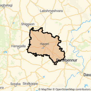
Haveri District Map
Current Corona Virus Infected Patients Count in Haveri District
| City Name | District Name | Total Covid cases |
|---|
Haveri Live Weather
Temperature: 26.7 °C
overcast clouds
Humidity: 79%
Wind : 6.17 mt/sec towards W
StationName : "HÄ\u0081veri"
observed on 44 Mins Back
Temperature: 26.7 °C
overcast clouds
Humidity: 79%
Wind : 6.17 mt/sec towards W
StationName : "HÄ\u0081veri"
observed on 44 Mins Back
Haveri Weather Forecast for Next 5 days
20-05-2026
24.1°C to 27.9°C
overcast clouds
24.1°C to 27.9°C
overcast clouds
21-05-2026
22.9°C to 30.9°C
overcast clouds, light rain, scattered clouds, broken clouds
22.9°C to 30.9°C
overcast clouds, light rain, scattered clouds, broken clouds
22-05-2026
23.0°C to 30.7°C
overcast clouds, light rain
23.0°C to 30.7°C
overcast clouds, light rain
23-05-2026
23.4°C to 31.8°C
overcast clouds, scattered clouds, broken clouds, light rain
23.4°C to 31.8°C
overcast clouds, scattered clouds, broken clouds, light rain
24-05-2026
23.8°C to 29.9°C
moderate rain, overcast clouds, broken clouds
23.8°C to 29.9°C
moderate rain, overcast clouds, broken clouds
Temples in Haveri
Historical Daily Min/Max Temperatures (Next 7 Days)
| Years | 18 May | 19 May | 20 May | 21 May | 22 May | 23 May | 24 May |
|---|---|---|---|---|---|---|---|
| 2025 | 27.0°C/ 25.0°C | 30.0°C/ 26.0°C | 29.0°C/ 23.0°C | 26.0°C/ 22.0°C | 27.0°C/ 23.0°C | 24.0°C/ 23.0°C | 24.0°C/ 23.0°C |
| 2024 | 34.0°C/ 27.0°C | 32.0°C/ 26.0°C | 33.0°C/ 23.0°C | 29.0°C/ 25.0°C | 33.0°C/ 29.0°C | 35.0°C/ 26.0°C | 33.0°C/ 26.0°C |
| 2023 | 38.0°C/ 26.0°C | 38.0°C/ 25.0°C | 38.0°C/ 24.0°C | 37.0°C/ 24.0°C | 35.0°C/ 25.0°C | 36.0°C/ 25.0°C | 35.0°C/ 25.0°C |
About Haveri District
Haveri District is one among 30 Districts of Karnataka State ,India. Haveri District Administrative head quarter is Haveri. It is is Located 364 KM East towards State capital Bangalore . Haveri District population is 1598506. It is 18 th Largest District in the State by population.Geography and Climate Haveri District
It is Located at Latitude-14.7, Longitude-75.4. Haveri District is sharing border with Davangere District to the East , Shimoga District to the South , Uttar Kannad District to the west . Haveri District occupies an area of approximately 26.19 square kilometres. . Its in the 688 meters to 558 meters elevation range.This District belongs to Southern India .DemoGraphics of Haveri District
Kannada is the Local Language here. Haveri District is divided into 7 Taluks , 220 Panchayats , 774 Villages. Byadgi Taluk is the Smallest Taluk by population with 127944 population. Ranebennur Taluk is the Biggest Taluk by population with 304990 population.Major producing Items,Crops,Industries and Exports from Haveri District
Bamboo, BambooHandicra, BambooHandyCr, BasketMaking, Baskets, Beedi, BrassArticles, Bricks, BroomSticks, CementSheets, Chilli, Chillies, Chilly, Coconut, Cotton, Dresses, EarthernPots, EathenStatues, are the major producing Items and Exports from here.Census 2011 of Haveri District
Haveri district Total population is 1598506 according to census 2011.Males are 819326 and Females are 779180 .Literate people are 1057572 among total.Its total area is 26.19 sq.km. It is the 18 th largest district in the state by Population . But 28 th Largest District in the state By Area. 310 th Largest District in the Country By Population. 10 th highest District in the State By literacy rate. 208 th highest District in the Country By literacy rate.its literacy Rate is 77.6Politics in Haveri District
Bharatiya Janata Party , Karnataka Prajnyavantha Janatha Party (KPJP) , BJP , Bharatiya Janata Party (BJP) , Indian National Congress (INC) , INC are the major political parties in Haveri District.Assembly constituencies in Haveri District
Total 6 Assembly constituencies in Haveri District.| Constituency name | MLA name | Party |
|---|---|---|
| Hangal | Mane Srinivas | Bharatiya Janata Party (BJP) |
| Shiggaon | Basavaraj bommai | Bharatiya Janata Party (BJP) |
| Haveri | Rudrappa Manappa Lamani | Bharatiya Janata Party (BJP) |
| Byadgi | Basavaraj Neelappa Shivannanavar | Bharatiya Janata Party (BJP) |
| Hirekerur | Ujaneshwar Basavannappa Banakar | Indian National Congress (INC) |
| Ranibennur | Prakash Koliwad | Karnataka Prajnyavantha Janatha Party (KPJP) |
Parliament constituencies in Haveri District
Total 2 Parliament constituencies in Haveri District.| Constituency name | MP name | Party |
|---|---|---|
| Haveri | UDASI. S.C. | Bharatiya Janata Party |
| Dharwad | Pralhad Joshi | Bharatiya Janata Party |
Haveri District Political Map
Haveri Commerce
Total Registered Comapnies with Ministry of Corporate Affairs (MCA) in Haveri are 97Company Name : NAVACHETANA MICROFIN SERVICES PRIVATE LIMITED
Type Of Business : Finance
Capital : 21.422 Crores
Company Name : NAVACHETANA ENTERPRISES HAVERI PRIVATE LIMITED
Type Of Business : Business Services
Capital : 19.64 Crores
Company Name : NAVACHETANA ENTERPRISES HAVERI PRIVATE LIMITED
Type Of Business : Business Services
Capital : 17.34 Crores
Company Name : CHETANA FINANCIAL SERVICES LIMITED
Type Of Business : Community, personal & Social Services
Capital : 6.3295 Crores
More Haveri Registered Companies
Haveri District Tourism
Haveri Transport
Road Transport
District Headquarters Haveri is well connected by road . Ranibennur , Savanur , Shiggaon are the Cities in this district having road connectivity to major towns and remote villages. Haveri is about 364 KM by road to Bangalore( Capital of Karnataka )Rail Transport
Some of the rail way stations in district are Haveri , Ranibennur , Yalvigi , Byadgi , Karajgi , Gudgeri , Savanur , Devargudda .... which connects most of the towns and villages in the District.Bus Transport
Karnataka State Road Transport Corporation ( KSRTC) runs Busses from Major cities to Towns and Villages in this District.
Pin Codes in Haveri District
581109
( Haunsabhavi ) ,
581208
( Halageri ) ,
581145
( Chalageri ) ,
581120
( Tilavalli ) ,
581102
( Akkialur ) ,
581210
( Masur (Haveri)) ,
581108
( Guttal ) ,
581213
( Hosaritti ) ,
581211
( Medleri ) ,
581123
( Kumarapattanam ) ,
581115
( Ranebennur ) ,
581148
( Sangur ) ,
581101
( Adur (Haveri)) ,
581203
( Bommanahalli (Haveri)) ,
581104
( Hangal ) ,
581128
( Agadi ) ,
581119
( Tumminakatti ) ,
581111
( Hirekerur ) ,
581193
( Dhundashi ) ,
581118
( Savanur ) ,
more PinCodes
Hotels in Haveri
BusStops in Haveri Lakes in Haveri Temples in Haveri Shops in Haveri Haveri Hospitals Hotel/Restaurants in Haveri Haveri RailwayStations Haveri BusStops ATM in Haveri
Tourist Places Around Haveri
Near Cities
Savanur 24 KM near
Ranibennur 33 KM near
Shiggaon 34 KM near
Lakshmeshwar 43 KM near
Near By Air Ports
Hubli Airport 80 KM near
Sambre Airport 162 KM near
Dabolim Airport 201 KM near
Bajpe Airport 235 KM near
Near By Districts
Haveri 0 KM near
Davangere 73 KM near
Gadag 84 KM near
Dharwad 94 KM near