| Home | City Bus | Maps | Villages | Cities | Rail | Tourist Places | School | College | Pin Codes | Corona Cases Count |
| Distance Calculator Bus Services IFSC Codes Trace Mobile Number Weather Search Place Trace IP Available Cash ATM/Banks Locate Polling Booth Report an Error contact People |
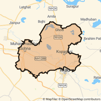
Mau District.
Currently In:
India >>
Uttar Pradesh
Division : Azamgarh
Head Quarters : Mau
Language : Hindi and Urdu
Area: 1713 sq. km
Population : 2205170
Sex Ratio : 978
Density : 1287/ sq. km
Literacy : 75.16
Elevation / Altitude: 79 - 69 meters. Above Seal level
Current Time 12:38 PM
Date: Monday , Jan 05,2026 (IST)
Time zone: IST (UTC+5:30)
District Pin code Index: 221XXX,275XXX,276XXX
Vehicle Registration Number: UP-54
RTO Office: Mau
Tourist Places near Mau
Sarnath (Mrigadava) Varanasi (Benares) Jaunpur Gorakhpur Kushinagar (Kusinagar) Sasaram
Sarnath (Mrigadava) Varanasi (Benares) Jaunpur Gorakhpur Kushinagar (Kusinagar) Sasaram
Mau District Map
Current Corona Virus Infected Patients Count in Mau District
| City Name | District Name | Total Covid cases |
|---|
Mau Live Weather
Temperature: 18.3 °C
clear sky
Humidity: 33%
Wind : 3.21 mt/sec towards W
StationName : "Mau"
observed on 19 Mins Back
Temperature: 18.3 °C
clear sky
Humidity: 33%
Wind : 3.21 mt/sec towards W
StationName : "Mau"
observed on 19 Mins Back
Mau Weather Forecast for Next 5 days
06-01-2026
8.6°C to 19.4°C
clear sky
8.6°C to 19.4°C
clear sky
07-01-2026
7.6°C to 21.1°C
clear sky
7.6°C to 21.1°C
clear sky
08-01-2026
9.6°C to 22.8°C
clear sky, scattered clouds
9.6°C to 22.8°C
clear sky, scattered clouds
09-01-2026
10.0°C to 22.4°C
scattered clouds, few clouds, broken clouds, overcast clouds
10.0°C to 22.4°C
scattered clouds, few clouds, broken clouds, overcast clouds
10-01-2026
8.9°C to 22.6°C
overcast clouds, broken clouds, scattered clouds, clear sky
8.9°C to 22.6°C
overcast clouds, broken clouds, scattered clouds, clear sky
Temples in Mau
Historical Daily Min/Max Temperatures (Next 7 Days)
| Years | 05 Jan | 06 Jan | 07 Jan | 08 Jan | 09 Jan | 10 Jan | 11 Jan |
|---|---|---|---|---|---|---|---|
| 2025 | 22.0°C/ 12.0°C | 22.0°C/ 11.0°C | |||||
| 2024 | 24.0°C/ 8.0°C | ||||||
| 2023 | 23.0°C/ 9.0°C | 21.0°C/ 8.0°C |
About Mau District
Mau District is one among 71 Districts of Uttar Pradesh State ,India. Mau District Administrative head quarter is Mau. It is is Located 327 KM west towards State capital Lucknow . Mau District population is 2205170. It is 44 th Largest District in the State by population.Geography and Climate Mau District
It is Located at Latitude-25.9, Longitude-83.5. Mau District is sharing border with Azamgarh District to the west , Ballia District to the East , Ghazipur District to the South , Gorakhpur District to the North . Mau District occupies an area of approximately 1713 square kilometres. . Its in the 79 meters to 69 meters elevation range.This District belongs to Hindi Belt India .DemoGraphics of Mau District
Hindi is the Local Language here. Also People Speaks Urdu . Mau District is divided into 10 Blocks , Panchayats , 3738 Villages.Census 2011 of Mau District
Mau district Total population is 2205170 according to census 2011.Males are 1114848 and Females are 1090322 .Literate people are 1458940 among total.Its total area is 1713 sq.km. It is the 44 th largest district in the state by Population . But 61 st Largest District in the state By Area. 205 th Largest District in the Country By Population. 10 th highest District in the State By literacy rate. 256 th highest District in the Country By literacy rate.its literacy Rate is 75.16Politics in Mau District
QED , SP , BSP are the major political parties in Mau District.Assembly constituencies in Mau District
Total 5 Assembly constituencies in Mau District.| Constituency name | MLA name | Party |
|---|---|---|
| Mubarakpur | Akhilesh | BSP |
| Madhuban | Ram Bilash Chauhan | BSP |
| Ghosi | Dara Singh Chauhan | SP |
| Muhammadabad Gohna | Rajendra Kumar | SP |
| Mau | Abbas Ansari | QED |
Parliament constituencies in Mau District
Total 2 Parliament constituencies in Mau District.| Constituency name | MP name | Party |
|---|---|---|
| Azamgarh | Akhilesh Yadav | Samajwadi Party |
| Ghosi | ATUL KUMAR SINGH | Bahujan Samaj Party |
Mau District Political Map
Mau Commerce
Total Registered Comapnies with Ministry of Corporate Affairs (MCA) in Mau are 177Company Name : KAUTUKI AGRO PRODUCTS PRIVATE LIMITED
Type Of Business : Agriculture and Allied Activities
Capital : 5.9675 Crores
Company Name : SHREE GANPATI RIDHI SIDHI AGRO INDUSTRIES PRIVATE LIMITED
Type Of Business : Manufacturing (Food stuffs)
Capital : 3.68634 Crores
Company Name : SRINATH SAREES PRIVATE LIMITED
Type Of Business : Trading
Capital : 2.091 Crores
Company Name : AARLON SYNTEX PRIVATE LIMITED
Type Of Business : Manufacturing (Textiles)
Capital : 1.7568 Crores
More Mau Registered Companies
Mau District Tourism
Mau Transport
Road Transport
District Headquarters Mau is well connected by road . Mau is about 327 KM by road to Lucknow( Capital of Uttar Pradesh )Rail Transport
Some of the rail way stations in district are Mau Junction , Indara Junction , Muhammadabad , Pipri Dih , Paniara , Ratanpura , Paligarh , Khurahat .... which connects most of the towns and villages in the District.Bus Transport
Uttar Pradesh State Road Transport ( UPSRTC) runs Busses from Major cities to Towns and Villages in this District.
Pin Codes in Mau District
221602
( Maryad Pur. ) ,
275302
( Bhopaura ) ,
275303
( Dohari Ghat ) ,
275101
( Mau ) ,
275105
( Jamal Mirja Pur ) ,
221601
( Dubari ) ,
221705
( Haldharpur ) ,
276129
( Chiraia Kot ) ,
221603
( Madhu Ban ) ,
275102
( Indara ) ,
275304
( Ghosi (Mau)) ,
221706
( Ratan Pura ) ,
275305
( Kopa Ganj ) ,
276403
( Mohd Bad Gohana Chowk ) ,
275307
( Semari Jamal Pur ) ,
276405
( Walid Pur ) ,
276402
( Karaha ) ,
275301
( Amila ) ,
121705
( Talai Pur) ,
more PinCodes
Hotels in Mau
Near Cities
Adari 8 KM near
Rasra 34 KM near
Ghazipur 43 KM near
Azamgarh 46 KM near
Near By Air Ports
Varanasi Airport 100 KM near
Gorakhpur Airport 102 KM near
Patna Airport 175 KM near
Gaya Airport 213 KM near
Near By Districts
Mau 0 KM near
Ghazipur 42 KM near
Azamgarh 46 KM near
Buxar 63 KM near