| Home | City Bus | Maps | Villages | Cities | Rail | Tourist Places | School | College | Pin Codes | Corona Cases Count |
| Distance Calculator Bus Services IFSC Codes Trace Mobile Number Weather Search Place Trace IP Available Cash ATM/Banks Locate Polling Booth Report an Error contact People |
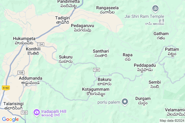
Kotnapalli
Kotnapalli Map
EDIT Map
Add Your House
 ..
..
Current Corona Virus Infected Patients Count in Visakhapatanam District
| City Name | District Name | Total Covid cases |
|---|---|---|
| Visakhapatnam District | Visakhapatnam | 14 |
| Narsipatnam | Visakhapatnam | 2 |
| Visakhapatnam | Visakhapatnam | 2 |
| Akkayyapelem | Visakhapatnam | 2 |
| Visakapatnam | Visakhapatnam | 1 |
| Gajuwaka | Visakhapatnam | 1 |
Locality Name :
Kotnapalli
( కోట్నపల్లి )
Mandal Name : Hukumpeta
District : Visakhapatanam
State : Andhra Pradesh
Region : Andhra
Language : Telugu
Current Time 01:42 AM
Date: Saturday , May 03,2025 (IST)
Time zone: IST (UTC+5:30)
Elevation / Altitude: 910 meters. Above Seal level
Telephone Code / Std Code: 08935
Assembly constituency : Alur assembly constituency
Assembly MLA : P Jayaram
Lok Sabha constituency : Kurnool parliamentary constituency
Parliament MP : AYUSHMAN DOCTOR SANJEEV KUMAR
Serpanch Name :
Pin Code : 531077
Post Office Name : Hukumpeta
Commodities Prices : Anakapally Market / Mandi
Kotnapalli Live Weather
Temperature: 20.7 °C
few clouds
Humidity: 74%
Wind : 0.96 mt/sec towards NW
StationName : "MÄ\u0081dugula"
observed on 2 Hours Back
Temperature: 20.7 °C
few clouds
Humidity: 74%
Wind : 0.96 mt/sec towards NW
StationName : "MÄ\u0081dugula"
observed on 2 Hours Back
Kotnapalli Weather Forecast for Next 5 days
03-05-2025
19.1°C to 20.9°C
few clouds, scattered clouds
19.1°C to 20.9°C
few clouds, scattered clouds
04-05-2025
17.4°C to 29.7°C
few clouds, clear sky, scattered clouds, light rain, broken clouds
17.4°C to 29.7°C
few clouds, clear sky, scattered clouds, light rain, broken clouds
05-05-2025
20.0°C to 30.9°C
clear sky, few clouds, scattered clouds, light rain, moderate rain
20.0°C to 30.9°C
clear sky, few clouds, scattered clouds, light rain, moderate rain
06-05-2025
18.7°C to 30.7°C
scattered clouds, few clouds, light rain, moderate rain, overcast clouds
18.7°C to 30.7°C
scattered clouds, few clouds, light rain, moderate rain, overcast clouds
07-05-2025
19.8°C to 31.0°C
broken clouds, overcast clouds
19.8°C to 31.0°C
broken clouds, overcast clouds
Rivers Near Kotnapalli
Pala Eru
Champavati
Pala Eru
Champavati
About Kotnapalli
Correct below Info and add more info about KotnapalliKotnapalli is a Village in Hukumpeta Mandal in Visakhapatanam District of Andhra Pradesh State, India. It belongs to Andhra region . It is located 80 KM towards west from District head quarters Vishakhapatnam. 539 KM from State capital Hyderabad
Kotnapalli Pin code is 531077 and postal head office is Hukumpeta .
Kotnapalli is surrounded by Paderu Mandal towards South , Dumbriguda Mandal towards North , Ananthagiri Mandal towards East , Araku Valley Mandal towards North .
Narsipatnam , Anakapalle , Salur , Sunabeda are the near by Cities to Kotnapalli.
Demographics of Kotnapalli
Telugu is the Local Language here.Politics in Kotnapalli
TDP , YSRC , Yuvajana Sramika Rythu Congress Party , PRAP , YSRCP , INC are the major political parties in this area.Polling Stations /Booths near Kotnapalli
1)M.kottala2)Nitravatti
3)P.kotakonda
4)P.kotakonda-
5)P.kotakonda-
HOW TO REACH Kotnapalli
By Rail
There is no railway station near to Kotnapalli in less than 10 km. Thadi Rail Way Station (near to Anakapalle) , Anakapalle Rail Way Station (near to Anakapalle) are the Rail way stations reachable from near by towns.By Road
Anakapalle are the nearby by towns to Kotnapalli having road connectivity to KotnapalliBy Bus
Paderu APSRTC Bus Station , Arakuvalley APSRTC Bus Station , Araku APSRTC Bus Station are the nearby by Bus Stations to Kotnapalli .APSRTC runs Number of busses from major cities to here.Colleges near Kotnapalli
Govt Jr College Hukumpeta Vizag
Address : Govt Jr College Hukumpeta Vizag
Schools near Kotnapalli
Kgbv Hukumpeta
Address : hukumpeta , hukumpeta , visakhapatnam , Andhra Pradesh . PIN- 531077 , Post - Hukumpeta
T.w.a.h.school Pedagaruvu
Address : pedagaruvu , hukumpeta , visakhapatnam , Andhra Pradesh . PIN- 531077 , Post - Hukumpeta
T W A High School Guda
Address : malaguda , hukumpeta , visakhapatnam , Andhra Pradesh . PIN- 531077 , Post - Hukumpeta
Zphs Bakuru
Address : bakuru , hukumpeta , visakhapatnam , Andhra Pradesh . PIN- 531077 , Post - Hukumpeta
Govt Health Centers near Kotnapalli
1) Bakuru , GOVERNMENT , Bakuru , NEAR BUS JUNCTION2) Pedagaruvu , GOVERNMENT , Pedagaruvu , GCC depo
3) Thadigiri , GOVERNMENT , GADDI COLONEY TADIGIRI , RICE MIL
Sub Villages in Kotnapalli
Electronic Shops in Kotnapalli,Hukumpeta
Super Markets in Kotnapalli,Hukumpeta
Local Parks in Kotnapalli,Hukumpeta
Police Stations near Kotnapalli,Hukumpeta
Governement Offices near Kotnapalli,Hukumpeta
About Kotnapalli &
History
How to reach Kotnapalli
Tourist Places Near By Kotnapalli
Schools in Kotnapalli
Colleges in Kotnapalli
Temperature & weather of Kotnapalli
places in Kotnapalli
Kotnapalli photos
More Information
How to reach Kotnapalli
Tourist Places Near By Kotnapalli
Schools in Kotnapalli
Colleges in Kotnapalli
Temperature & weather of Kotnapalli
places in Kotnapalli
Kotnapalli photos
More Information
Village Talk
Post News or Events about this Village
Near Cities
Narsipatnam 59 KM near
Anakapalle 63 KM near
Salur 70 KM near
Sunabeda 75 KM near
Narsipatnam 59 KM near
Anakapalle 63 KM near
Salur 70 KM near
Sunabeda 75 KM near
Near By Taluks
Hukumpeta 0 KM near
Paderu 13 KM near
Dumbriguda 21 KM near
Ananthagiri 29 KM near
Hukumpeta 0 KM near
Paderu 13 KM near
Dumbriguda 21 KM near
Ananthagiri 29 KM near
Near By Air Ports
Vishakhapatnam Airport 73 KM near
Rajahmundry Airport 169 KM near
Vijayawada Airport 307 KM near
Raipur Airport 399 KM near
Vishakhapatnam Airport 73 KM near
Rajahmundry Airport 169 KM near
Vijayawada Airport 307 KM near
Raipur Airport 399 KM near
Near By Tourist Places
Ananthagiri 27 KM near
Araku Valley 27 KM near
Simhachalam 72 KM near
Vizayanagaram 74 KM near
Visakhapatnam 76 KM near
Ananthagiri 27 KM near
Araku Valley 27 KM near
Simhachalam 72 KM near
Vizayanagaram 74 KM near
Visakhapatnam 76 KM near
Near By Districts
Vizianagaram 76 KM near
Visakhapatanam 76 KM near
Koraput 85 KM near
Malkangiri 107 KM near
Vizianagaram 76 KM near
Visakhapatanam 76 KM near
Koraput 85 KM near
Malkangiri 107 KM near
Near By RailWay Station
Kottavalasa Junction Rail Way Station 57 KM near
Anakapalle Rail Way Station 61 KM near
Kottavalasa Junction Rail Way Station 57 KM near
Anakapalle Rail Way Station 61 KM near