| Home | City Bus | Maps | Villages | Cities | Rail | Tourist Places | School | College | Pin Codes | Corona Cases Count |
| Distance Calculator Bus Services IFSC Codes Trace Mobile Number Weather Search Place Trace IP Available Cash ATM/Banks Locate Polling Booth Report an Error contact People |
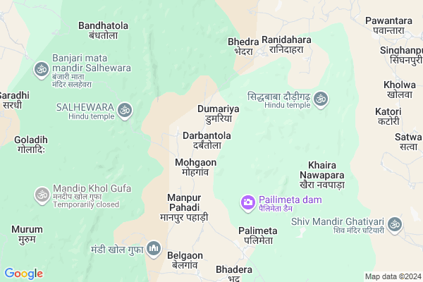
Darbantola
Darbantola Map
EDIT Map
Add Your House
 ..
..
Current Corona Virus Infected Patients Count in Rajnandgaon District
| City Name | District Name | Total Covid cases |
|---|---|---|
| Rajnandgaon | Rajnandgaon | 1 |
Locality Name :
Darbantola
( दरबांटोला )
Tehsil Name : Chhuikhadan
District : Rajnandgaon
State : Chattisgarh
Language : Chhattisgarhi and Hindi
Current Time 01:25 AM
Date: Saturday , May 03,2025 (IST)
Time zone: IST (UTC+5:30)
Elevation / Altitude: 319 meters. Above Seal level
Telephone Code / Std Code: 07743
Assembly constituency : Khairagarh assembly constituency
Assembly MLA : Yashoda Nilamber Verma
Lok Sabha constituency : Rajnandgaon parliamentary constituency
Parliament MP : SANTOSH PANDEY
Serpanch Name :
Pin Code : 491888
Post Office Name : Gandai Pandaria
Commodities Prices : Gandai Market / Mandi
Darbantola Live Weather
Temperature: 28.5 °C
clear sky
Humidity: 37%
Wind : 0.91 mt/sec towards W
StationName : "Gandai"
observed on 28 Mins Back
Temperature: 28.5 °C
clear sky
Humidity: 37%
Wind : 0.91 mt/sec towards W
StationName : "Gandai"
observed on 28 Mins Back
Darbantola Weather Forecast for Next 5 days
03-05-2025
26.0°C to 27.1°C
clear sky
26.0°C to 27.1°C
clear sky
04-05-2025
26.2°C to 40.5°C
clear sky, scattered clouds, light rain, broken clouds
26.2°C to 40.5°C
clear sky, scattered clouds, light rain, broken clouds
05-05-2025
25.9°C to 39.7°C
few clouds, clear sky, scattered clouds, light rain, broken clouds
25.9°C to 39.7°C
few clouds, clear sky, scattered clouds, light rain, broken clouds
06-05-2025
26.0°C to 41.2°C
scattered clouds, few clouds, clear sky, broken clouds
26.0°C to 41.2°C
scattered clouds, few clouds, clear sky, broken clouds
07-05-2025
26.3°C to 40.9°C
broken clouds, scattered clouds, clear sky, few clouds
26.3°C to 40.9°C
broken clouds, scattered clouds, clear sky, few clouds
Rivers Near Darbantola
Shivnath :Seonath
Tanda
Shivnath :Seonath
Tanda
About Darbantola
Correct below Info and add more info about DarbantolaDarbantola is a Village in Chhuikhadan Tehsil in Rajnandgaon District of Chattisgarh State, India. It is located 81 KM towards North from District head quarters Rajnandgaon. 14 KM from Chhuikhadan. 100 KM from State capital Raipur
Darbantola Pin code is 491888 and postal head office is Gandai Pandaria .
Jiratola ( 13 KM ) , Khouda ( 14 KM ) , Jamgaon ( 15 KM ) , Gerukhadan ( 15 KM ) , Salhewara ( 16 KM ) are the nearby Villages to Darbantola. Darbantola is surrounded by S.Lohara Tehsil towards East , Khairagarh Tehsil towards South , Birsa Tehsil towards North , Saja Tehsil towards East .
Malajkhand , Kawardha , Bemetra , Dongargarh are the near by Cities to Darbantola.
Darbantola 2011 Census Details
Darbantola Local Language is Chhattisgarhi. Darbantola Village Total population is 853 and number of houses are 196. Female Population is 50.3%. Village literacy rate is 50.4% and the Female Literacy rate is 20.2%.
Population
| Census Parameter | Census Data |
| Total Population | 853 |
| Total No of Houses | 196 |
| Female Population % | 50.3 % ( 429) |
| Total Literacy rate % | 50.4 % ( 430) |
| Female Literacy rate | 20.2 % ( 172) |
| Scheduled Tribes Population % | 85.6 % ( 730) |
| Scheduled Caste Population % | 1.8 % ( 15) |
| Working Population % | 59.9 % |
| Child(0 -6) Population by 2011 | 145 |
| Girl Child(0 -6) Population % by 2011 | 47.6 % ( 69) |
Darbantola Census More Deatils.
Politics in Darbantola
Bharatiya Janata Party , BJP , INC are the major political parties in this area.Polling Stations /Booths near Darbantola
1)Dullapur2)Dapka
3)Maradkathera
4)Manpur
5)Padmavatipur
HOW TO REACH Darbantola
By Rail
There is no railway station near to Darbantola in less than 10 km.Colleges near Darbantola
Veerangana Avanti Bai Govt. College
Address : Chhuikhadan, Raipur
Schools in Darbantola
P.s. Darbantola
Address : darbantola , chuikhadan , rajnandgaon , Chattisgarh . PIN- 491881 , Post - Khairagah Raj
Govt Health Centers near Darbantola
1) PHC Pailimeta , Primary Health Center Pailimeta , ,2) SHC Mohgaon , Sub Health Center Mohgaon , ,
3) SHC Champatola , Sub Health Center Champatola , ,
Petrol Bunks in Darbantola,Chhuikhadan
Indian Oil Petrol Pump
Nayapara; Gandai; Rajnandgaon; SH-5; Dalli Rajhara Bhanupratappur Road; Khairagarh; Khairagarh; Chhattisgarh 491441; India
17.1 KM distance Detail
HP PETROL PUMP - MAA GANGAI FUELS
HP Petrol Pump Gandai Dhamdha Road Gandai; Raipur; Chhattisgarh 491888; India
17.9 KM distance Detail
more ..
Colleges in Darbantola,Chhuikhadan
AIIT GROUP OF INSTITUTIONS GANDAI
Pandariya Road; Gandai; Chhattisgarh 491888; India
16.7 KM distance Detail
Late Shri Devi Prasad Ji Choubey Govt. College; Gandai
Gandai; Chhattisgarh 491888; India
17.0 KM distance Detail
more ..
Schools in Darbantola,Chhuikhadan
Jawahar Navodaya Vidyalaya
Gyanpur (Bhadohi); Sant Ravidas Nagar; Uttar Pradesh; Sant Ravidas Nagar; Uttar Pradesh 221304; India
15.6 KM distance Detail
Govt. Boys H. S. School Gandai
Ward No. 6 ; Gandai; SH 5; Gandai; Chhattisgarh 491888; India
16.1 KM distance Detail
Local Parks in Darbantola,Chhuikhadan
About Darbantola &
History
How to reach Darbantola
Tourist Places Near By Darbantola
Schools in Darbantola
Colleges in Darbantola
Temperature & weather of Darbantola
places in Darbantola
Darbantola photos
More Information
How to reach Darbantola
Tourist Places Near By Darbantola
Schools in Darbantola
Colleges in Darbantola
Temperature & weather of Darbantola
places in Darbantola
Darbantola photos
More Information
Village Talk
Post News or Events about this Village
Near Cities
Malajkhand 46 KM near
Kawardha 49 KM near
Bemetra 64 KM near
Dongargarh 70 KM near
Malajkhand 46 KM near
Kawardha 49 KM near
Bemetra 64 KM near
Dongargarh 70 KM near
Near By Taluks
Chhuikhadan 13 KM near
S.Lohara 24 KM near
Khairagarh 38 KM near
Birsa 39 KM near
Chhuikhadan 13 KM near
S.Lohara 24 KM near
Khairagarh 38 KM near
Birsa 39 KM near
Near By Air Ports
Raipur Airport 111 KM near
Jabalpur Airport 168 KM near
Sonegaon Airport 235 KM near
Khajuraho Airport 404 KM near
Raipur Airport 111 KM near
Jabalpur Airport 168 KM near
Sonegaon Airport 235 KM near
Khajuraho Airport 404 KM near
Near By Tourist Places
Kawardha 47 KM near
Durg 75 KM near
Rajnandgaon 77 KM near
Bhilai 79 KM near
Kanha National park 81 KM near
Kawardha 47 KM near
Durg 75 KM near
Rajnandgaon 77 KM near
Bhilai 79 KM near
Kanha National park 81 KM near
Near By Districts
Kabirdham 46 KM near
Durg 75 KM near
Rajnandgaon 78 KM near
Balaghat 91 KM near
Kabirdham 46 KM near
Durg 75 KM near
Rajnandgaon 78 KM near
Balaghat 91 KM near
Near By RailWay Station
Dongargarh Rail Way Station 70 KM near
Durg Junction Rail Way Station 74 KM near
Dongargarh Rail Way Station 70 KM near
Durg Junction Rail Way Station 74 KM near