| Home | City Bus | Maps | Villages | Cities | Rail | Tourist Places | School | College | Pin Codes | Corona Cases Count |
| Distance Calculator Bus Services IFSC Codes Trace Mobile Number Weather Search Place Trace IP Available Cash ATM/Banks Locate Polling Booth Report an Error contact People |
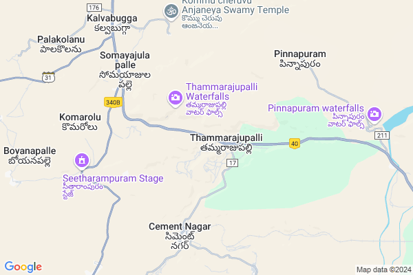
Thammarajupalle
Thammarajupalle Map
EDIT Map
Add Your House
 ..
..
Current Corona Virus Infected Patients Count in Kurnool District
| City Name | District Name | Total Covid cases |
|---|---|---|
| Kurnool District | Kurnool | 191 |
| Kurnool | Kurnool | 16 |
| Nandyal | Kurnool | 8 |
| Nandyala | Kurnool | 6 |
| Ganigali Street | Kurnool | 4 |
| Maddur | Kurnool | 3 |
| Banaganapalli | Kurnool | 3 |
| Habeeb Mubarak Nagar | Kurnool | 3 |
| Gani Gali Street | Kurnool | 2 |
| - | Kurnool | 2 |
| Gadivemula | Kurnool | 2 |
| Nandyal Town | Kurnool | 1 |
| Bedamcherla | Kurnool | 1 |
| Nadyal | Kurnool | 1 |
| Osmania College Road | Kurnool | 1 |
| Chagala Marri | Kurnool | 1 |
| Khadakpura | Kurnool | 1 |
| Atmukur | Kurnool | 1 |
| Gonampalle | Kurnool | 1 |
| Budhavur Petta | Kurnool | 1 |
| Atmakur | Kurnool | 1 |
| Pedda | Kurnool | 1 |
| Sangaih Pet | Kurnool | 1 |
| Revenue Colony | Kurnool | 1 |
| Ayyaluru | Kurnool | 1 |
| Kodumur | Kurnool | 1 |
| Chittari | Kurnool | 1 |
| Prakasam Nagar | Kurnool | 1 |
| Kotaveedhi | Kurnool | 1 |
| Budhawarapetta | Kurnool | 1 |
| Chandabada | Kurnool | 1 |
| KVR Garden | Kurnool | 1 |
| Banaganapalle Mandal | Kurnool | 1 |
| Nandavaram | Kurnool | 1 |
| Nandikotkur | Kurnool | 1 |
| Padidempadu | Kurnool | 1 |
| A-park road | Kurnool | 1 |
| Devanagar | Kurnool | 1 |
| Kodaru | Kurnool | 1 |
| Ganigalli | Kurnool | 1 |
| Islam petta, Atmakur | Kurnool | 1 |
| Nagappa Street | Kurnool | 1 |
| Athmakur | Kurnool | 1 |
| Panyam | Kurnool | 1 |
| Shalisaheb Street | Kurnool | 1 |
| Malyala Village | Kurnool | 1 |
| Nandyala Mandal | Kurnool | 1 |
| SriLakshmi Nagar | Kurnool | 1 |
| Budhavarpeta | Kurnool | 1 |
| Narsingh Rao Pet | Kurnool | 1 |
Locality Name :
Thammarajupalle
( ధమ్మరాజుపల్లె )
Mandal Name : Panyam
District : Kurnool
State : Andhra Pradesh
Region : Rayalaseema
Language : Telugu and Urdu
Current Time 11:34 PM
Date: Friday , May 02,2025 (IST)
Time zone: IST (UTC+5:30)
Elevation / Altitude: 227 meters. Above Seal level
Telephone Code / Std Code: 08514
Assembly constituency : assembly constituency
Assembly MLA : KATASANI RAMBHUPAL REDDY
Lok Sabha constituency : parliamentary constituency
Parliament MP : POCHA . BRAHMANANDA REDDY
Serpanch Name :
Pin Code : 518112
Post Office Name : Panem
Commodities Prices : Allagadda Market / Mandi
National Highways Reachable To Thammarajupalle
Nationa High Way :NH40
Nationa High Way :NH40
Rivers Near Thammarajupalle
Kannikala Vagu
Kundu River
Kannikala Vagu
Kundu River
About Thammarajupalle
Correct below Info and add more info about ThammarajupalleThammarajupalle is a Village in Panyam Mandal in Kurnool District of Andhra Pradesh State, India. It belongs to Rayalaseema region . It is located 40 KM towards South from District head quarters Kurnool. 20 KM from Panyam. 240 KM from State capital Hyderabad
Thammarajupalle Pin code is 518112 and postal head office is Panem .
Kalva ( 9 KM ) , Palakolanu ( 10 KM ) , Bugganipalle ( 11 KM ) , Husainapuram ( 12 KM ) , Emboy ( 13 KM ) are the nearby Villages to Thammarajupalle. Thammarajupalle is surrounded by Panyam Mandal towards East , Bethamcherla Mandal towards South , Midthur Mandal towards North , Banaganapalle Mandal towards South .
Bethamcherla , Chapirevula , Banganapalle , Nandyal are the near by Cities to Thammarajupalle.
Thammarajupalle 2011 Census Details
Thammarajupalle Local Language is Telugu. Thammarajupalle Village Total population is 2144 and number of houses are 520. Female Population is 49.8%. Village literacy rate is 40.4% and the Female Literacy rate is 15.3%.
Population
| Census Parameter | Census Data |
| Total Population | 2144 |
| Total No of Houses | 520 |
| Female Population % | 49.8 % ( 1067) |
| Total Literacy rate % | 40.4 % ( 866) |
| Female Literacy rate | 15.3 % ( 328) |
| Scheduled Tribes Population % | 0.0 % ( 1) |
| Scheduled Caste Population % | 15.3 % ( 328) |
| Working Population % | 57.9 % |
| Child(0 -6) Population by 2011 | 271 |
| Girl Child(0 -6) Population % by 2011 | 52.4 % ( 142) |
Thammarajupalle Census More Deatils.
HOW TO REACH Thammarajupalle
By Road
Nandyal is the Nearest Town to Thammarajupalle. Nandyal is 31 km from Thammarajupalle. Road connectivity is there from Nandyal to Thammarajupalle.By Rail
Krishnamma Kona Rail Way Station , Bugganipalli Cement Nagar Rail Way Station are the very nearby railway stations to Thammarajupalle. Also you can consider railway Stations from Near By town Nandyal. Nandyal Junction Rail Way Station are the railway Stations near to Nandyal. You can reach from Nandyal to Thammarajupalle by road after .By Bus
Panyam APSRTC Bus Station , Bethamcherla APSRTC Bus Station , Banaganapally APSRTC Bus Station are the nearby by Bus Stations to Thammarajupalle .APSRTC runs Number of busses from major cities to here.Colleges near Thammarajupalle
T C Govt Junior College Panyam
Address : T C Govt Junior College Panyam
Schools in Thammarajupalle
Zphs Thammarajupalle
Address : thammarajupalle , panyam , kurnool , Andhra Pradesh . PIN- 518112 , Post - Panem
Govt Health Centers near Thammarajupalle
1) Cement Nagar II , 10- , G.Type , G.Type2) Bugganipally , 3-300 , Main Road , Nr.Cell Tower
3) R.Konthalapadu , 3RD WARD , SC COLONY , SC COLONY
Hospitals in Thammarajupalle,Panyam
Sree Gnaneswari Nature Cure Hospital
betahamcherla cross road;Somayajulapalle;Orvakallu mandal; Andhra Pradesh 518206; India
7.5 KM distance Detail
Primary Health Centre
National Highway 18; Hussaina Puram; Andhra Pradesh 518002; India
11.8 KM distance Detail
more ..
Petrol Bunks in Thammarajupalle,Panyam
HP PETROL PUMP - G K M QUALITY FUELS
HPC Dealer NH-18; Kurnool-kadapa Road S.NO. 49; Tamarajupalle (V) &; Andhra Pradesh 518543; India
3.0 KM distance Detail
Bharat Petroleum Bunk
Bethamcherla - Kurnool Rd; Andhra Pradesh 518112; India
7.5 KM distance Detail
more ..
Colleges in Thammarajupalle,Panyam
Sri Gnana Saraswathi Inter And Degree College
Betamcherla; Andhra Pradesh 518206; India
14.7 KM distance Detail
Indira Priyadarshini College of Engineering and Technology for Women Kurnool
Nannur ;Orvakal; Kurnool; Andhra Pradesh 518001; India
17.9 KM distance Detail
more ..
Schools in Thammarajupalle,Panyam
Bugga Rameswaram High School
National Highway 18; Andhra Pradesh 518002; India
10.1 KM distance Detail
Electronic Shops in Thammarajupalle,Panyam
KGN Computers
Shop No : 4-281; SBI Road; Betamcherla.; Bethamcherla Cement Nagar Rd; Betamcherla; Andhra Pradesh 518599; India
7.9 KM distance Detail
Local Parks in Thammarajupalle,Panyam
Rock Garden - A P Tourism
Orvakal; National Highway 18; Andhra Pradesh 518002; India
20.3 KM distance Detail
Governement Offices near Thammarajupalle,Panyam
MeeSeva Center
Main Road; Beside SBI; 4/233-1; Betamcherla; Andhra Pradesh 518599; India
15.1 KM distance Detail
About Thammarajupalle &
History
How to reach Thammarajupalle
Tourist Places Near By Thammarajupalle
Schools in Thammarajupalle
Colleges in Thammarajupalle
Temperature & weather of Thammarajupalle
places in Thammarajupalle
Thammarajupalle photos
More Information
How to reach Thammarajupalle
Tourist Places Near By Thammarajupalle
Schools in Thammarajupalle
Colleges in Thammarajupalle
Temperature & weather of Thammarajupalle
places in Thammarajupalle
Thammarajupalle photos
More Information
Village Talk
Post News or Events about this Village
Near Cities
Bethamcherla 15 KM near
Chapirevula 28 KM near
Banganapalle 29 KM near
Nandyal 33 KM near
Bethamcherla 15 KM near
Chapirevula 28 KM near
Banganapalle 29 KM near
Nandyal 33 KM near
Near By Taluks
Orvakal 16 KM near
Panyam 19 KM near
Bethamcherla 21 KM near
Banaganapalle 26 KM near
Orvakal 16 KM near
Panyam 19 KM near
Bethamcherla 21 KM near
Banaganapalle 26 KM near
Near By Air Ports
Rajiv Gandhi International Airport 211 KM near
Tirupati Airport 286 KM near
Bengaluru International Airport 299 KM near
Vijayawada Airport 331 KM near
Rajiv Gandhi International Airport 211 KM near
Tirupati Airport 286 KM near
Bengaluru International Airport 299 KM near
Vijayawada Airport 331 KM near
Near By Tourist Places
Kurnool 39 KM near
Srisailam 101 KM near
Mantralayam 106 KM near
Kadapa 153 KM near
Puttaparthi 179 KM near
Kurnool 39 KM near
Srisailam 101 KM near
Mantralayam 106 KM near
Kadapa 153 KM near
Puttaparthi 179 KM near
Near By Districts
Kurnool 39 KM near
Anantapur 131 KM near
Raichur 132 KM near
Mahbubnagar 151 KM near
Kurnool 39 KM near
Anantapur 131 KM near
Raichur 132 KM near
Mahbubnagar 151 KM near
Near By RailWay Station
Krishnamma Kona Rail Way Station 7.3 KM near
Bugganipalli Cement Nagar Rail Way Station 8.8 KM near
Betamcherla Rail Way Station 15 KM near
Nandyal Junction Rail Way Station 31 KM near
Krishnamma Kona Rail Way Station 7.3 KM near
Bugganipalli Cement Nagar Rail Way Station 8.8 KM near
Betamcherla Rail Way Station 15 KM near
Nandyal Junction Rail Way Station 31 KM near