| Home | City Bus | Maps | Villages | Cities | Rail | Tourist Places | School | College | Pin Codes | Corona Cases Count |
| Distance Calculator Bus Services IFSC Codes Trace Mobile Number Weather Search Place Trace IP Available Cash ATM/Banks Locate Polling Booth Report an Error contact People |
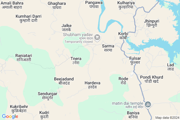
Sarma
Sarma Map
EDIT Map
Add Your House
 ..
..
Current Corona Virus Infected Patients Count in Korba District
| City Name | District Name | Total Covid cases |
|---|---|---|
| Korba District | Korba | 25 |
| Katghora | Korba | 3 |
Locality Name :
Sarma
( शर्मा )
Tehsil Name : Podi Uparoda
District : Korba
State : Chattisgarh
Language : Chhattisgarhi and Hindi
Current Time 02:10 AM
Date: Sunday , May 04,2025 (IST)
Time zone: IST (UTC+5:30)
Elevation / Altitude: 293 meters. Above Seal level
Telephone Code / Std Code: 07815
Assembly constituency : Pali-Tanakhar assembly constituency
Assembly MLA : Tuleshwar Hira Singh Markam
Lok Sabha constituency : Korba parliamentary constituency
Parliament MP : JYOTSNA CHARANDAS MAHANT
Serpanch Name :
Pin Code : 495445
Post Office Name : Katghora
Commodities Prices : Katghora Market / Mandi
Sarma Live Weather
Temperature: 24.0 °C
clear sky
Humidity: 52%
Wind : 2.02 mt/sec towards S
StationName : "PasÄ\u0081n"
observed on Now
Temperature: 24.0 °C
clear sky
Humidity: 52%
Wind : 2.02 mt/sec towards S
StationName : "PasÄ\u0081n"
observed on Now
Sarma Weather Forecast for Next 5 days
04-05-2025
24.2°C to 24.2°C
clear sky
24.2°C to 24.2°C
clear sky
05-05-2025
23.3°C to 39.0°C
clear sky, light rain, overcast clouds
23.3°C to 39.0°C
clear sky, light rain, overcast clouds
06-05-2025
24.8°C to 38.7°C
overcast clouds, few clouds, clear sky, scattered clouds, light rain, broken clouds
24.8°C to 38.7°C
overcast clouds, few clouds, clear sky, scattered clouds, light rain, broken clouds
07-05-2025
25.0°C to 39.7°C
few clouds, scattered clouds, clear sky, broken clouds, overcast clouds
25.0°C to 39.7°C
few clouds, scattered clouds, clear sky, broken clouds, overcast clouds
08-05-2025
28.0°C to 40.7°C
overcast clouds, broken clouds, scattered clouds
28.0°C to 40.7°C
overcast clouds, broken clouds, scattered clouds
Rivers Near Sarma
Samarsuta
Chornai
Samarsuta
Chornai
About Sarma
Correct below Info and add more info about SarmaSarma is a Village in Podi Uparoda Tehsil in Korba District of Chattisgarh State, India. It is located 74 KM towards North from District head quarters Korba. 25 KM from Podi Uparoda. 228 KM from State capital Raipur
Sarma Pin code is 495445 and postal head office is Katghora .
Jhinpurii ( 8 KM ) , Sasin ( 11 KM ) , Matin ( 13 KM ) , Pipariya ( 13 KM ) , Kodgar ( 14 KM ) are the nearby Villages to Sarma. Sarma is surrounded by Khadgawana Tehsil towards North , Premnagar Tehsil towards East , Marwahi Tehsil towards west , Gaurella-1 Tehsil towards west .
Chirmiri , Dipka , Pasan , Kotma are the near by Cities to Sarma.
Sarma 2011 Census Details
Sarma Local Language is Chhattisgarhi. Sarma Village Total population is 1221 and number of houses are 252. Female Population is 50.9%. Village literacy rate is 49.6% and the Female Literacy rate is 20.8%.
Population
| Census Parameter | Census Data |
| Total Population | 1221 |
| Total No of Houses | 252 |
| Female Population % | 50.9 % ( 622) |
| Total Literacy rate % | 49.6 % ( 606) |
| Female Literacy rate | 20.8 % ( 254) |
| Scheduled Tribes Population % | 82.6 % ( 1009) |
| Scheduled Caste Population % | 5.2 % ( 63) |
| Working Population % | 57.6 % |
| Child(0 -6) Population by 2011 | 193 |
| Girl Child(0 -6) Population % by 2011 | 49.7 % ( 96) |
Sarma Census More Deatils.
Politics in Sarma
Indian National Congress , BJP , INC are the major political parties in this area.Polling Stations /Booths near Sarma
1)Kothikharra2)Korbi
3)Ringaniya
4)Etmanagar
5)Arsiya
HOW TO REACH Sarma
By Rail
There is no railway station near to Sarma in less than 10 km.Colleges near Sarma
Govt. College Kartala
Address :
P G Collage Korba
Address : Gorhi
gorhi
gorhi
Jifsa Pvt. Iti - Industrial Training Institute
Address : Jifsa Pvt. Iti Industrial Training Institute,
residential & Training Practical Ground,
gevra Bypass Road, Kuchaina, Kusmunda
korba, Chhattisgarh India
Institute Of Technology (it)
Address : Korba, Vill-rumgara, P.o. – Balco Nagar, Korba (c
Modern Institute Of Managment And Technology
Address : Behind Icici Bank,t P Nagar
Schools in Sarma
Pms Sarma
Address : sarma , pondi-uproda , korba , Chattisgarh . PIN- 495445 , Post - Katghora
Govt Health Centers near Sarma
1) KORBI , SHC-KORBI , NEAR GRAM PANCHAYAT BHAVAN -KORBI , NEAR GRAM PANCHAYAT BHAVAN -KORBI2) TRANERA , SHC-TANERA , NEAR PANCHYAT BHAVAN-TANERA , NEAR PANCHYAT BHAVAN-TANERA
3) JHINPURI , SHC-JHINPURI , NEAR GRAM PANCHAYAT BHAVAN -JHINPURI , INFRONT OF GOVT. MIDDLE SCHOOL - JHINPURI
Local Parks in Sarma,Podi Uparoda
Governement Offices near Sarma,Podi Uparoda
About Sarma &
History
How to reach Sarma
Tourist Places Near By Sarma
Schools in Sarma
Colleges in Sarma
Temperature & weather of Sarma
places in Sarma
Sarma photos
More Information
How to reach Sarma
Tourist Places Near By Sarma
Schools in Sarma
Colleges in Sarma
Temperature & weather of Sarma
places in Sarma
Sarma photos
More Information
Village Talk
Post News or Events about this Village
Near Cities
Chirmiri 44 KM near
Dipka 64 KM near
Pasan 64 KM near
Kotma 66 KM near
Chirmiri 44 KM near
Dipka 64 KM near
Pasan 64 KM near
Kotma 66 KM near
Near By Taluks
Podi Uparoda 24 KM near
Khadgawana 28 KM near
Premnagar 41 KM near
Marwahi 44 KM near
Podi Uparoda 24 KM near
Khadgawana 28 KM near
Premnagar 41 KM near
Marwahi 44 KM near
Near By Air Ports
Raipur Airport 221 KM near
Jabalpur Airport 286 KM near
Varanasi Airport 327 KM near
Bamrauli Airport 331 KM near
Raipur Airport 221 KM near
Jabalpur Airport 286 KM near
Varanasi Airport 327 KM near
Bamrauli Airport 331 KM near
Near By Tourist Places
Baikunthpur 52 KM near
Korba 69 KM near
Amarkantak 77 KM near
Janjgir-Champa 88 KM near
Ambikapur 96 KM near
Baikunthpur 52 KM near
Korba 69 KM near
Amarkantak 77 KM near
Janjgir-Champa 88 KM near
Ambikapur 96 KM near
Near By Districts
Korea 54 KM near
Korba 70 KM near
Anuppur 88 KM near
Surguja 97 KM near
Korea 54 KM near
Korba 70 KM near
Anuppur 88 KM near
Surguja 97 KM near
Near By RailWay Station
Pendra Road Rail Way Station 59 KM near
Jaithari Rail Way Station 64 KM near
Pendra Road Rail Way Station 59 KM near
Jaithari Rail Way Station 64 KM near