| Home | City Bus | Maps | Villages | Cities | Rail | Tourist Places | School | College | Pin Codes | Corona Cases Count |
| Distance Calculator Bus Services IFSC Codes Trace Mobile Number Weather Search Place Trace IP Available Cash ATM/Banks Locate Polling Booth Report an Error contact People |
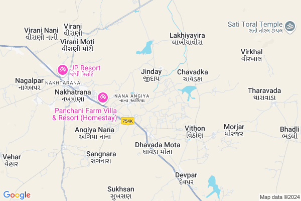
Angiya Mota
Angiya Mota Map
EDIT Map
Add Your House
 ..
..
Current Corona Virus Infected Patients Count in Kachchh District
| City Name | District Name | Total Covid cases |
|---|
Locality Name :
Angiya Mota
( અંગિયા મોટા )
Taluka Name : Nakhatrana
District : Kachchh
State : Gujarat
Language : Gujarati and Sindhi, And Hindi, Kutchi
Current Time 05:50 PM
Date: Saturday , May 03,2025 (IST)
Time zone: IST (UTC+5:30)
Elevation / Altitude: 89 meters. Above Seal level
Telephone Code / Std Code: 02835
Assembly constituency : Abdasa assembly constituency
Assembly MLA : Jadeja Pradhyumansinh Mahipatsinh
Lok Sabha constituency : Kutch parliamentary constituency
Parliament MP : CHAVDA VINOD LAKHAMSHI
Serpanch Name :
Pin Code : 370675
Post Office Name : Vithon
Alternate Village Name : Angiyamota
Angiya Mota Live Weather
Temperature: 32.4 °C
clear sky
Humidity: 47%
Wind : 9.81 mt/sec towards W
StationName : "Roha"
observed on 11 Mins Back
Temperature: 32.4 °C
clear sky
Humidity: 47%
Wind : 9.81 mt/sec towards W
StationName : "Roha"
observed on 11 Mins Back
Angiya Mota Weather Forecast for Next 5 days
04-05-2025
25.7°C to 30.9°C
clear sky, broken clouds
25.7°C to 30.9°C
clear sky, broken clouds
05-05-2025
25.7°C to 35.8°C
broken clouds, overcast clouds, clear sky, scattered clouds
25.7°C to 35.8°C
broken clouds, overcast clouds, clear sky, scattered clouds
06-05-2025
25.9°C to 34.3°C
broken clouds, few clouds, scattered clouds, clear sky
25.9°C to 34.3°C
broken clouds, few clouds, scattered clouds, clear sky
07-05-2025
26.6°C to 34.4°C
few clouds, overcast clouds, broken clouds, light rain
26.6°C to 34.4°C
few clouds, overcast clouds, broken clouds, light rain
08-05-2025
27.2°C to 34.8°C
overcast clouds, scattered clouds, few clouds, clear sky, light rain, broken clouds
27.2°C to 34.8°C
overcast clouds, scattered clouds, few clouds, clear sky, light rain, broken clouds
National Highways Reachable To Angiya Mota
Nationa High Way :NH341
Nationa High Way :NH341
About Angiya Mota
Correct below Info and add more info about Angiya MotaAngiya Mota is a Village in Nakhatrana Taluka in Kachchh District of Gujarat State, India. It is located 43 KM towards west from District head quarters Bhuj. 5 KM from Nakhatrana Nana. 398 KM from State capital Gandhinagar
Angiya Mota Pin code is 370675 and postal head office is Vithon .
Dhavda Mota ( 3 KM ) , Dhavda Nana ( 4 KM ) , Angiya Nana ( 4 KM ) , Vithon ( 4 KM ) , Sangnara ( 5 KM ) are the nearby Villages to Angiya Mota. Angiya Mota is surrounded by Bhuj Taluka towards East , Abdasa Taluka towards west , Mandvi Taluka towards South , Mundra Taluka towards South .
Bhuj , Mandvi , Adipur , Gandhidham are the near by Cities to Angiya Mota.
Angiya Mota 2011 Census Details
Angiya Mota Local Language is Gujarati. Angiya Mota Village Total population is 1227 and number of houses are 251. Female Population is 49.2%. Village literacy rate is 53.4% and the Female Literacy rate is 21.9%.
Population
| Census Parameter | Census Data |
| Total Population | 1227 |
| Total No of Houses | 251 |
| Female Population % | 49.2 % ( 604) |
| Total Literacy rate % | 53.4 % ( 655) |
| Female Literacy rate | 21.9 % ( 269) |
| Scheduled Tribes Population % | 0.5 % ( 6) |
| Scheduled Caste Population % | 12.4 % ( 152) |
| Working Population % | 34.9 % |
| Child(0 -6) Population by 2011 | 145 |
| Girl Child(0 -6) Population % by 2011 | 47.6 % ( 69) |
Angiya Mota Census More Deatils.
Politics in Angiya Mota
Bharatiya Janata Party , BJP , INC are the major political parties in this area.Polling Stations /Booths near Angiya Mota
1)Muru2)Vithon - 1
3)Anandsar (v)
4)Naliya- 7
5)Nana Angia - 1
HOW TO REACH Angiya Mota
By Rail
There is no railway station near to Angiya Mota in less than 10 km.Colleges near Angiya Mota
Srk Institute Of Social Science
Address : Srk Institute Of Social Science,sapeda, Tal. Anjar
Schools in Angiya Mota
Angiya Mota Primary Shala
Address : angiya mota , nakhatrana , kachchh , Gujarat . PIN- 370658
Govt Health Centers near Angiya Mota
1) Ref. Hospital Mandvi , 2-Dec , Layja Road Mandvi , Near nana bus standPetrol Bunks in Angiya Mota,Nakhatrana
Essar Petrol Pump
Bhuj - Nakhatrana Rd; Sahjanand nagar; Mirjapar; Bhuj; Gujarat 370040; India
2.3 KM distance Detail
more ..
Schools in Angiya Mota,Nakhatrana
Sant Shree Khetabapa Highschool - Vithon
Vithon Rd; Vithon; Gujarat 370675; India
3.9 KM distance Detail
Police Stations near Angiya Mota,Nakhatrana
Governement Offices near Angiya Mota,Nakhatrana
HEMANG C JOSHI RTO & INSURANCE & PUC ADVISOR
Nakhatrana; Gujarat 370615; India
6.5 KM distance Detail
About Angiya Mota &
History
How to reach Angiya Mota
Tourist Places Near By Angiya Mota
Schools in Angiya Mota
Colleges in Angiya Mota
Temperature & weather of Angiya Mota
places in Angiya Mota
Angiya Mota photos
More Information
How to reach Angiya Mota
Tourist Places Near By Angiya Mota
Schools in Angiya Mota
Colleges in Angiya Mota
Temperature & weather of Angiya Mota
places in Angiya Mota
Angiya Mota photos
More Information
Village Talk
Post News or Events about this Village
Near Cities
Bhuj 41 KM near
Mandvi 60 KM near
Adipur 93 KM near
Gandhidham 102 KM near
Bhuj 41 KM near
Mandvi 60 KM near
Adipur 93 KM near
Gandhidham 102 KM near
Near By Taluks
Nakhatrana 5 KM near
Bhuj 42 KM near
Abdasa 48 KM near
Mandvi 50 KM near
Nakhatrana 5 KM near
Bhuj 42 KM near
Abdasa 48 KM near
Mandvi 50 KM near
Near By Air Ports
Rudra Mata Airport 40 KM near
Kandla Airport 94 KM near
Govardhanpur Airport 134 KM near
Civil Airport 211 KM near
Rudra Mata Airport 40 KM near
Kandla Airport 94 KM near
Govardhanpur Airport 134 KM near
Civil Airport 211 KM near
Near By Tourist Places
Bhuj 41 KM near
Mandvi 60 KM near
Gandhidham 99 KM near
Dholavira 122 KM near
Kutch 139 KM near
Bhuj 41 KM near
Mandvi 60 KM near
Gandhidham 99 KM near
Dholavira 122 KM near
Kutch 139 KM near
Near By Districts
Kachchh 41 KM near
Jamnagar 139 KM near
Porbandar 212 KM near
Rajkot 213 KM near
Kachchh 41 KM near
Jamnagar 139 KM near
Porbandar 212 KM near
Rajkot 213 KM near
Near By RailWay Station
Bhuj Rail Way Station 42 KM near
Anjar Rail Way Station 86 KM near
Bhuj Rail Way Station 42 KM near
Anjar Rail Way Station 86 KM near