| Home | City Bus | Maps | Villages | Cities | Rail | Tourist Places | School | College | Pin Codes | Corona Cases Count |
| Distance Calculator Bus Services IFSC Codes Trace Mobile Number Weather Search Place Trace IP Available Cash ATM/Banks Locate Polling Booth Report an Error contact People |
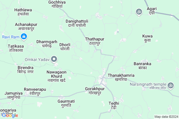
Mohbhatta
Mohbhatta Map
EDIT Map
Add Your House
 ..
..
Current Corona Virus Infected Patients Count in Kabirdham District
| City Name | District Name | Total Covid cases |
|---|
Locality Name :
Mohbhatta
( मोहभट्ठा )
Tehsil Name : S.lohara
District : Kabirdham
State : Chattisgarh
Language : Chhattisgarhi and Hindi, Agariya
Current Time 05:46 AM
Date: Saturday , May 03,2025 (IST)
Time zone: IST (UTC+5:30)
Elevation / Altitude: 292 meters. Above Seal level
Telephone Code / Std Code: 07741
Assembly constituency : Pandariya assembly constituency
Assembly MLA : Bhawna Bohra
Lok Sabha constituency : Rajnandgaon parliamentary constituency
Parliament MP : SANTOSH PANDEY
Serpanch Name :
Pin Code : 491336
Post Office Name : Dashrangpur
Main Village Name : Mohbhatta
Commodities Prices : Pipriya Market / Mandi
Rivers Near Mohbhatta
Son
Shivnath :Seonath
Son
Shivnath :Seonath
About Mohbhatta
Correct below Info and add more info about MohbhattaMohbhatta is a small Village/hamlet in S.lohara Tehsil in Kabirdham District of Chattisgarh State, India. It comes under Mohbhatta Panchayath. It is located 26 KM towards South from District head quarters Kawardha. 18 KM from S.Lohara. 82 KM from State capital Raipur
Mohbhatta Pin code is 491336 and postal head office is Dashrangpur .
Bagdai ( 8 KM ) , Birendranagar ( 8 KM ) , Dudhiya ( 9 KM ) , Gochhiya ( 9 KM ) , Pendra ( 9 KM ) are the nearby Villages to Mohbhatta. Mohbhatta is surrounded by Kawardha Tehsil towards North , Kabirdham Tehsil towards North , Saja Tehsil towards South , Bemetara Tehsil towards East .
Kawardha , Bemetra , Mungeli , Tilda Newra are the near by Cities to Mohbhatta.
Mohbhatta 2011 Census Details
Mohbhatta Local Language is Chhattisgarhi. Mohbhatta Village Total population is 518 and number of houses are 91. Female Population is 51.5%. Village literacy rate is 42.9% and the Female Literacy rate is 17.6%.
Population
| Census Parameter | Census Data |
| Total Population | 518 |
| Total No of Houses | 91 |
| Female Population % | 51.5 % ( 267) |
| Total Literacy rate % | 42.9 % ( 222) |
| Female Literacy rate | 17.6 % ( 91) |
| Scheduled Tribes Population % | 25.7 % ( 133) |
| Scheduled Caste Population % | 2.3 % ( 12) |
| Working Population % | 49.8 % |
| Child(0 -6) Population by 2011 | 83 |
| Girl Child(0 -6) Population % by 2011 | 51.8 % ( 43) |
Mohbhatta Census More Deatils.
Politics in Mohbhatta
Bharatiya Janata Party , BJP , INC are the major political parties in this area.Polling Stations /Booths near Mohbhatta
1)Mauhamadwa2)Gorkhpur
3)Jhiriyakla
4)Dhodhama Nawapara
5)Tenduadih
HOW TO REACH Mohbhatta
By Rail
There is no railway station near to Mohbhatta in less than 10 km.Colleges near Mohbhatta
Government Swami Vivekanand Collage Bodla
Address :
Naw Govt. Science College Pipariya
Address : Main Road Pipariya
Shekh Sameer College Mungeli Road,pandariya
Address : Shekh Sameer College Mungeli Road,pandariya
Shekh Sameer Pg College Pandariya
Address : Shekh Sameer Auto Care Mungeli Road,pandariya Distt.-kabirdham(c.g.)491559 Pass Pandariya
Ma Bamleshwary Medical Institute
Address : Kawardha, Raipur
Schools near Mohbhatta
N.m.s. Kalyanpur
Address : kalyanpur , sahaspur lohara , kawardha , Chattisgarh . PIN- 491995 , Post - Kawardha
N.m.s. Khaira
Address : khaira , sahaspur lohara , kawardha , Chattisgarh . PIN- 491995 , Post - Kawardha
J.b.m.s. Khairbana
Address : khairbana , sahaspur lohara , kawardha , Chattisgarh . PIN- 491995 , Post - Kawardha
G.m.s. Dhiyahandih
Address : dhiyahandih , sahaspur lohara , kawardha , Chattisgarh . PIN- 491995 , Post - Kawardha
Govt Health Centers near Mohbhatta
1) SHC Rampur , , Rampur sector ,2) PHC Rampur , Rampur hospital Building , Rampur sector ,
3) SHC Banraka , Sub Health Center , Banraka , Near Govt high School , Thankhamhariya Road
Sub Villages in Mohbhatta
Schools in Mohbhatta,S.lohara
Odia Primary School
Odia; Odiya; Bemetara; NH-12A; Simga Kawardha Road; Bemetara; Bemetara; Chhattisgarh 491335; India
13.1 KM distance Detail
Electronic Shops in Mohbhatta,S.lohara
Akpatre Electronics And Repairs Shop Odiya
Odiya; Chhattisgarh 491335; India
13.0 KM distance Detail
Chandrakar Electronics Kodawa Amit Chandrakar
Bhurkuda; Chhattisgarh 491336; India
18.6 KM distance Detail
Super Markets in Mohbhatta,S.lohara
Mahalxmi Brtan Bhandar
Sikriganj - Gorakhpur Main Rd; Raut Dadee; Uttar Pradesh 491335; India
21.2 KM distance Detail
Local Parks in Mohbhatta,S.lohara
Police Stations near Mohbhatta,S.lohara
Police Station
Birampur - Thengabhat Road; Darhi; Chhattisgarh 491335; India
21.3 KM distance Detail
Governement Offices near Mohbhatta,S.lohara
About Mohbhatta &
History
How to reach Mohbhatta
Tourist Places Near By Mohbhatta
Schools in Mohbhatta
Colleges in Mohbhatta
Temperature & weather of Mohbhatta
places in Mohbhatta
Mohbhatta photos
More Information
How to reach Mohbhatta
Tourist Places Near By Mohbhatta
Schools in Mohbhatta
Colleges in Mohbhatta
Temperature & weather of Mohbhatta
places in Mohbhatta
Mohbhatta photos
More Information
Village Talk
Post News or Events about this Village
Near Cities
Kawardha 23 KM near
Bemetra 28 KM near
Mungeli 52 KM near
Tilda Newra 63 KM near
Kawardha 23 KM near
Bemetra 28 KM near
Mungeli 52 KM near
Tilda Newra 63 KM near
Near By Taluks
S.Lohara 18 KM near
Kawardha 19 KM near
Kabirdham 23 KM near
Saja 25 KM near
S.Lohara 18 KM near
Kawardha 19 KM near
Kabirdham 23 KM near
Saja 25 KM near
Near By Air Ports
Raipur Airport 92 KM near
Jabalpur Airport 192 KM near
Sonegaon Airport 277 KM near
Khajuraho Airport 406 KM near
Raipur Airport 92 KM near
Jabalpur Airport 192 KM near
Sonegaon Airport 277 KM near
Khajuraho Airport 406 KM near
Near By Tourist Places
Kawardha 25 KM near
Bhilai 76 KM near
Durg 78 KM near
Raipur 79 KM near
Rajnandgaon 96 KM near
Kawardha 25 KM near
Bhilai 76 KM near
Durg 78 KM near
Raipur 79 KM near
Rajnandgaon 96 KM near
Near By Districts
Kabirdham 25 KM near
Durg 78 KM near
Raipur 80 KM near
Rajnandgaon 96 KM near
Kabirdham 25 KM near
Durg 78 KM near
Raipur 80 KM near
Rajnandgaon 96 KM near
Near By RailWay Station
Tilda Rail Way Station 64 KM near
Bhatapara Rail Way Station 73 KM near
Tilda Rail Way Station 64 KM near
Bhatapara Rail Way Station 73 KM near