| Home | City Bus | Maps | Villages | Cities | Rail | Tourist Places | School | College | Pin Codes | Corona Cases Count |
| Distance Calculator Bus Services IFSC Codes Trace Mobile Number Weather Search Place Trace IP Available Cash ATM/Banks Locate Polling Booth Report an Error contact People |
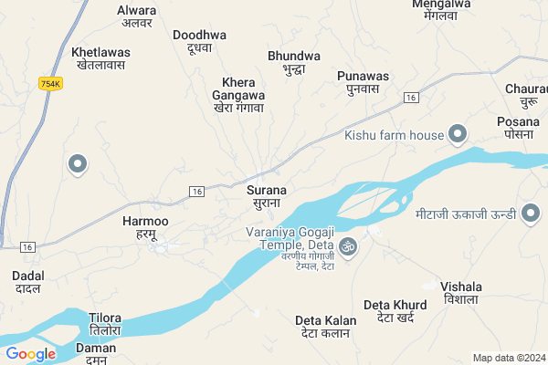
Surana Map
EDIT Map
Add Your House
 ..
..
Current Corona Virus Infected Patients Count in Jalore District
| City Name | District Name | Total Covid cases |
|---|
Locality Name :
Surana
( सुराणा )
Tehsil Name : Sayla
District : Jalore
State : Rajasthan
Division : Jodhpur
Language : Hindi and Rajasthani
Current Time 02:15 AM
Date: Sunday , May 04,2025 (IST)
Time zone: IST (UTC+5:30)
Elevation / Altitude: 140 meters. Above Seal level
Telephone Code / Std Code: 02977
Assembly constituency : Jalore assembly constituency
Assembly MLA : Jogeshwar Garg
Lok Sabha constituency : Jalore parliamentary constituency
Parliament MP : Devaji Patel
Serpanch Name :
Pin Code : 343032
Post Office Name : Bagoda
Commodities Prices : Bhinmal Market / Mandi
Edit below overview about Surana
Edit below overview about Surana
OverView of Surana
Surana village Located near Teh. Sayla in jalore District. In Surana village a famous temple Dadaji vir Vikram singh ji mandir, a Dadaji goshala samiti also locatedEdit below overview about Surana
National Highways Reachable To Surana
Nationa High Way :NH325
Nationa High Way :NH325
Rivers Near Surana
Jawai
Sukri (Sayala)
Jawai
Sukri (Sayala)
About Surana
Surana is a Village in Sayla Tehsil in Jalore District of Rajasthan State, India. It belongs to Jodhpur Division . It is located 59 KM towards west from District head quarters Jalore. 20 KM from Sayla. 482 KM from State capital Jaipur
Surana Pin code is 343032 and postal head office is Bagoda .
Sayla ( 7 KM ) , Komta ( 10 KM ) , Kaleti ( 10 KM ) , Mengalwa ( 11 KM ) , Posana ( 11 KM ) are the nearby Villages to Surana. Surana is surrounded by Sayla Tehsil towards East , Raniwara Tehsil towards South , Jaswantpura Tehsil towards South , Sindhari Tehsil towards North .
Bhinmal , Jalore , Sanchore , Sirohi are the near by Cities to Surana.
Surana 2011 Census Details
Surana Local Language is Hindi. Surana Village Total population is 8391 and number of houses are 1350. Female Population is 47.7%. Village literacy rate is 35.3% and the Female Literacy rate is 10.3%.
Population
| Census Parameter | Census Data |
| Total Population | 8391 |
| Total No of Houses | 1350 |
| Female Population % | 47.7 % ( 4003) |
| Total Literacy rate % | 35.3 % ( 2963) |
| Female Literacy rate | 10.3 % ( 861) |
| Scheduled Tribes Population % | 9.4 % ( 790) |
| Scheduled Caste Population % | 17.1 % ( 1435) |
| Working Population % | 49.9 % |
| Child(0 -6) Population by 2011 | 1539 |
| Girl Child(0 -6) Population % by 2011 | 46.8 % ( 721) |
Surana Census More Deatils.
Politics in Surana
Bharatiya Janata Party , BJP , INC are the major political parties in this area.Polling Stations /Booths near Surana
1)Govt. Ps Malnath Ki Dhani Jalore2)Govt. Senior Secondray School Left Room Santhu
3)Govt. Senior Secondray School Left Room No. 2. Ummedabad
4)Govt. Senior Secondray School Room No. 6 Sayla
5)Govt. Ups Hanuman Shala Left Room No.3 Bagora Road Jalore
HOW TO REACH Surana
By Rail
There is no railway station near to Surana in less than 10 km.Colleges near Surana
Sayala College Sayala
Address : Sayala
Kanaram Gevarammali Junior Digri College Asana
Address :
Nitmt Institute Of Agri. Business
Address : Nitmt Institute Of Agri. Business & Rural Mgt. Col
Schools in Surana
Sarswati Vidya Mandir Surana
Address : surana , sayla , jalor , Rajasthan . PIN- 343022 , Post - Sayla (Jalor)
Mammai.pub.sch.
Address : surana , sayla , jalor , Rajasthan . PIN- 343032 , Post - Bagoda
G..sen.sec.sch. Surana
Address : surana , sayla , jalor , Rajasthan . PIN- 343022 , Post - Sayla (Jalor)
Govt Health Centers near Surana
1) Punawas , Punawas , Punawas , Punawas2) Oatwala , Oatwala , Oatwala , Oatwala
3) Punrau , GOvt. School KE Samne , Punrau , Punrau
Schools in Surana,Sayla
GOVT.SEN.SEC SCHOOL SURANA (JALORE)
mdr16 sayala; Bagora - Sayla Rd; Surana; Rajasthan; India
0.5 KM distance Detail
Budharam
Surana Bhawan; Vikas Marg; School Block; Lalita Park; Laxmi Nagar; New Delhi; Delhi 110092; India
0.5 KM distance Detail
Super Markets in Surana,Sayla
Ratio Dealer (Bhagwat Singh)
31; Rajputo ka vas; Deta Khurd; Rajasthan; India
7.9 KM distance Detail
Police Stations near Surana,Sayla
Police Station
Reodar-Bhinmal-Rangala ( Sindhari ); Bagoda; Rajasthan 343032; India
14.1 KM distance Detail
About Surana &
History
How to reach Surana
Tourist Places Near By Surana
Schools in Surana
Colleges in Surana
Temperature & weather of Surana
places in Surana
Surana photos
More Information
How to reach Surana
Tourist Places Near By Surana
Schools in Surana
Colleges in Surana
Temperature & weather of Surana
places in Surana
Surana photos
More Information
Village Talk
Post News or Events about this Village
Near Cities
Bhinmal 31 KM near
Jalore 53 KM near
Sanchore 73 KM near
Sirohi 91 KM near
Bhinmal 31 KM near
Jalore 53 KM near
Sanchore 73 KM near
Sirohi 91 KM near
Near By Taluks
Sayla 18 KM near
Bhinmal 19 KM near
Raniwara 40 KM near
Jaswantpura 48 KM near
Sayla 18 KM near
Bhinmal 19 KM near
Raniwara 40 KM near
Jaswantpura 48 KM near
Near By Air Ports
Jodhpur Airport 163 KM near
Dabok Airport 212 KM near
Jaisalmer Airport 250 KM near
Ahmedabad Airport 276 KM near
Jodhpur Airport 163 KM near
Dabok Airport 212 KM near
Jaisalmer Airport 250 KM near
Ahmedabad Airport 276 KM near
Near By Tourist Places
Jalore 55 KM near
Mount Abu 103 KM near
Barmer 106 KM near
Sirohi 115 KM near
Banaskantha 136 KM near
Jalore 55 KM near
Mount Abu 103 KM near
Barmer 106 KM near
Sirohi 115 KM near
Banaskantha 136 KM near
Near By Districts
Jalore 56 KM near
Sirohi 91 KM near
Barmer 106 KM near
Banas Kantha 136 KM near
Jalore 56 KM near
Sirohi 91 KM near
Barmer 106 KM near
Banas Kantha 136 KM near
Near By RailWay Station
Balotra Rail Way Station 74 KM near
Samdari Junction Rail Way Station 88 KM near
Balotra Rail Way Station 74 KM near
Samdari Junction Rail Way Station 88 KM near