| Home | City Bus | Maps | Villages | Cities | Rail | Tourist Places | School | College | Pin Codes | Corona Cases Count |
| Distance Calculator Bus Services IFSC Codes Trace Mobile Number Weather Search Place Trace IP Available Cash ATM/Banks Locate Polling Booth Report an Error contact People |
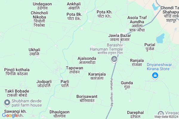
Ajalsonda
Ajalsonda Map
EDIT Map
Add Your House
 ..
..
Current Corona Virus Infected Patients Count in Hingoli District
| City Name | District Name | Total Covid cases |
|---|---|---|
| Hingoli District | Hingoli | 8 |
Locality Name :
Ajalsonda
( ज़ळसोंडा )
Taluka Name : Aundha Nagnath
District : Hingoli
State : Maharashtra
Region : Marathwada
Division : Aurangabad
Language : Marathi and Hindi
Current Time 03:52 PM
Date: Saturday , May 03,2025 (IST)
Time zone: IST (UTC+5:30)
Elevation / Altitude: 434 meters. Above Seal level
Telephone Code / Std Code: 02456
Assembly constituency : Basmath assembly constituency
Assembly MLA : Chandrakant Alias Rajubhaiyya Ramakant Nawghare
Lok Sabha constituency : Hingoli parliamentary constituency
Parliament MP : Hemant Patil
Serpanch Name :
Pin Code : 431705
Post Office Name : Aundha Nagnath
Commodities Prices : Jawala-Bajar Market / Mandi
National Highways Reachable To Ajalsonda
Nationa High Way :NH53
Nationa High Way :NH752K
Nationa High Way :NH53
Nationa High Way :NH752K
Rivers Near Ajalsonda
Saraswati Nadi
Kowlas nala
Saraswati Nadi
Kowlas nala
About Ajalsonda
Correct below Info and add more info about AjalsondaAjalsonda is a Village in Aundha Nagnath Taluka in Hingoli District of Maharashtra State, India. It belongs to Marathwada region . It belongs to Aurangabad Division . It is located 44 KM towards South from District head quarters Hingoli. 17 KM from Aundha Nagnath. 505 KM from State capital Mumbai
Ajalsonda Pin code is 431705 and postal head office is Aundha Nagnath .
Nalegaon ( 2 KM ) , Karanjala ( 3 KM ) , Berula ( 4 KM ) , Nandkheda ( 4 KM ) , Parli ( 5 KM ) are the nearby Villages to Ajalsonda. Ajalsonda is surrounded by Basmat Taluka towards East , Parbhani Taluka towards South , Purna Taluka towards South , Jintur Taluka towards west .
Parbhani , Purna , Manwath , Nanded-Waghala are the near by Cities to Ajalsonda.
Ajalsonda 2011 Census Details
Ajalsonda Local Language is Marathi. Ajalsonda Village Total population is 2726 and number of houses are 559. Female Population is 49.2%. Village literacy rate is 63.6% and the Female Literacy rate is 27.6%.
Population
| Census Parameter | Census Data |
| Total Population | 2726 |
| Total No of Houses | 559 |
| Female Population % | 49.2 % ( 1340) |
| Total Literacy rate % | 63.6 % ( 1734) |
| Female Literacy rate | 27.6 % ( 753) |
| Scheduled Tribes Population % | 0.3 % ( 7) |
| Scheduled Caste Population % | 16.9 % ( 462) |
| Working Population % | 55.5 % |
| Child(0 -6) Population by 2011 | 360 |
| Girl Child(0 -6) Population % by 2011 | 45.8 % ( 165) |
Ajalsonda Census More Deatils.
Politics in Ajalsonda
NCP , Shivsena , INC , SHS are the major political parties in this area.Polling Stations /Booths near Ajalsonda
1)Z. P. Pra. Sha. Ajarasonda East Wing Room No. 12)Z. P. Pra Shala Vagaravadi Tanda Room No 1
3)Z. P. Pra. Sha. Takalagavhan T. Aundha Room No 1
4)Z. P. Pra. Sha. Tapavan Room No. 2
5)Z.p.p.s. Karanjala North Wing Room No.1
HOW TO REACH Ajalsonda
By Rail
There is no railway station near to Ajalsonda in less than 10 km. Pimpla Chaure Halt Rail Way Station (near to Basmath) , Dhamni Rail Way Station (near to Hingoli) , Basmat Rail Way Station (near to Basmath) , Nawalgohan Rail Way Station (near to Hingoli) are the Rail way stations reachable from near by towns.By Road
Hingoli , Basmath , Jintur are the nearby by towns to Ajalsonda having road connectivity to AjalsondaColleges near Ajalsonda
Madhomati Sec And Higher Sec School Lakh
Address :
Schools in Ajalsonda
Zpps.ajalsonda
Address : ajalsonda , aundha nagnath , hingoli , Maharashtra . PIN- 431705 , Post - Aundha Nagnath
Govt Health Centers near Ajalsonda
1) Pota BK , sub centre pota bk , z.p school road , z.p shcoool2) Purjal , sc purjal , Near purjal raod , z.p.school
3) Sawangi , Sub center building , , Anganwadi
Hospitals in Ajalsonda,Aundha Nagnath
Government Hospital
Adgaon; Hingoli; SH-171; Basmat Parbhani Road; Hingoli; Hingoli; Maharashtra 431705; India
9.4 KM distance Detail
more ..
Petrol Bunks in Ajalsonda,Aundha Nagnath
Hindustan Petroleum
Aundha Nagnath; Hingoli; Parbhani Hingoli Road; Nanded Anudha Road; Hingoli; Hingoli; Maharashtra 431705; India
12.3 KM distance Detail
Indian Oil Petrol Pump
Aundha Nagnath; Hingoli; Parbhani Hingoli Road; Nanded Anudha Road; Hingoli; Hingoli; Maharashtra 431705; India
12.6 KM distance Detail
more ..
Colleges in Ajalsonda,Aundha Nagnath
Barashiv Hanuman JR collage
Parbhani - Hingoli Road; Barashiv Hanuman; Maharashtra 431705; India
3.5 KM distance Detail
computer IT
MAIN OFFICE NAHAD SHIRADSHAHAPUR; NAHAD; shiradshahapur; SHIRADSHAHAPUR; Maharashtra 431705; India
14.1 KM distance Detail
Annapurna Devi Junior College
Aral; Hingoli; NH-222; Ardhapur Basmat Road; Hingoli; Hingoli; Maharashtra 431512; India
14.5 KM distance Detail
more ..
Governement Offices near Ajalsonda,Aundha Nagnath
Village Panchayat Hiverkheda
Hiwarkheda; Hingoli; Jintur Nanded Road; Hingoli; Hingoli; Maharashtra 431705; India
13.0 KM distance Detail
Village Panchayat Dagarwadi
Aundha Nagnath; Hingoli; Parbhani Hingoli Road; Nanded Anudha Road; Hingoli; Hingoli; Maharashtra 431705; India
13.2 KM distance Detail
About Ajalsonda &
History
How to reach Ajalsonda
Tourist Places Near By Ajalsonda
Schools in Ajalsonda
Colleges in Ajalsonda
Temperature & weather of Ajalsonda
places in Ajalsonda
Ajalsonda photos
More Information
How to reach Ajalsonda
Tourist Places Near By Ajalsonda
Schools in Ajalsonda
Colleges in Ajalsonda
Temperature & weather of Ajalsonda
places in Ajalsonda
Ajalsonda photos
More Information
Village Talk
Post News or Events about this Village
Near Cities
Parbhani 28 KM near
Purna 32 KM near
Manwath 55 KM near
Nanded-Waghala 57 KM near
Parbhani 28 KM near
Purna 32 KM near
Manwath 55 KM near
Nanded-Waghala 57 KM near
Near By Taluks
Aundha Nagnath 16 KM near
Basmat 23 KM near
Parbhani 29 KM near
Purna 35 KM near
Aundha Nagnath 16 KM near
Basmat 23 KM near
Parbhani 29 KM near
Purna 35 KM near
Near By Air Ports
Nanded Airport 53 KM near
Latur Airport 140 KM near
Chikkalthana Airport 189 KM near
Sholapur Airport 255 KM near
Nanded Airport 53 KM near
Latur Airport 140 KM near
Chikkalthana Airport 189 KM near
Sholapur Airport 255 KM near
Near By Tourist Places
Hingoli 42 KM near
Washim 85 KM near
Aurangabad 198 KM near
Bidar 204 KM near
Tuljapur 206 KM near
Hingoli 42 KM near
Washim 85 KM near
Aurangabad 198 KM near
Bidar 204 KM near
Tuljapur 206 KM near
Near By Districts
Parbhani 29 KM near
Hingoli 42 KM near
Nanded 54 KM near
Washim 85 KM near
Parbhani 29 KM near
Hingoli 42 KM near
Nanded 54 KM near
Washim 85 KM near
Near By RailWay Station
Basmat Rail Way Station 27 KM near
Parbhani Junction Rail Way Station 30 KM near
Basmat Rail Way Station 27 KM near
Parbhani Junction Rail Way Station 30 KM near