| Home | City Bus | Maps | Villages | Cities | Rail | Tourist Places | School | College | Pin Codes | Corona Cases Count |
| Distance Calculator Bus Services IFSC Codes Trace Mobile Number Weather Search Place Trace IP Available Cash ATM/Banks Locate Polling Booth Report an Error contact People |
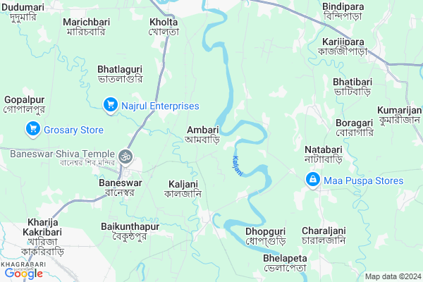
Ambari
Ambari Map
EDIT Map
Add Your House
 ..
..
Current Corona Virus Infected Patients Count in Coochbehar District
| City Name | District Name | Total Covid cases |
|---|
Locality Name :
Ambari
( আমবাড়ি )
Block Name : Cooch Behar Ii
District : Coochbehar
State : West Bengal
Division : Jalpaiguri
Language : Bengali and Hindi
Current Time 09:25 PM
Date: Friday , May 02,2025 (IST)
Time zone: IST (UTC+5:30)
Elevation / Altitude: 44 meters. Above Seal level
Telephone Code / Std Code: 03582
Assembly constituency : Cooch Behar Uttar assembly constituency
Assembly MLA : Sukumar Roy
Lok Sabha constituency : Cooch Behar parliamentary constituency
Parliament MP : NISITH PRAMANIK
Serpanch Name :
Pin Code : 736133
Post Office Name : Baneswar
Commodities Prices : Alipurduar Market / Mandi
Edit below overview about Ambari
Edit below overview about Ambari
OverView of Ambari
Mahamaya temple is famous of the district at coochbehar... founder by coochbehar raja pran narayan may be established 1857.every year a huge fair is held on the eighth betting dateEdit below overview about Ambari
National Highways Reachable To Ambari
Nationa High Way :SNH7
Nationa High Way :NH27
Nationa High Way :SNH7
Nationa High Way :NH27
Rivers Near Ambari
:Puna Tsang Chhu;Puna Tsang Chu Puna Tsang Chhu :Sankoš :Sankosh River :Río Sankosh
Jaldhaka River
:Puna Tsang Chhu;Puna Tsang Chu Puna Tsang Chhu :Sankoš :Sankosh River :Río Sankosh
Jaldhaka River
About Ambari
Ambari is a Village in Cooch Behar Ii Block in Coochbehar District of West Bengal State, India. It belongs to Jalpaiguri Division . It is located 13 KM towards North from District head quarters Cooch Behar. 9 KM from Cooch Behar Ii. 518 KM from State capital Kolkata
Ambari Pin code is 736133 and postal head office is Baneswar .
Baneswar ( 5 KM ) , Marichbari-kholta ( 6 KM ) , Khapaidanga ( 9 KM ) , Gopalpur ( 10 KM ) , Gosanimari ( 11 KM ) are the nearby Villages to Ambari. Ambari is surrounded by Alipurduar-I Block towards North , Cooch Behar-I Block towards South , Tufanganj-I Block towards East , Alipurduar-Ii Block towards East .
Alipurduar , Cooch Behar , Mathabhanga , Gauripur are the near by Cities to Ambari.
This Place is in the border of the Coochbehar District and Jalpaiguri District. Jalpaiguri District Alipurduar-i is North towards this place .
Ambari 2011 Census Details
Ambari Local Language is Bengali. Ambari Village Total population is 8926 and number of houses are 2202. Female Population is 48.0%. Village literacy rate is 72.6% and the Female Literacy rate is 31.8%.
Population
| Census Parameter | Census Data |
| Total Population | 8926 |
| Total No of Houses | 2202 |
| Female Population % | 48.0 % ( 4285) |
| Total Literacy rate % | 72.6 % ( 6479) |
| Female Literacy rate | 31.8 % ( 2835) |
| Scheduled Tribes Population % | 1.1 % ( 99) |
| Scheduled Caste Population % | 88.0 % ( 7859) |
| Working Population % | 41.6 % |
| Child(0 -6) Population by 2011 | 1043 |
| Girl Child(0 -6) Population % by 2011 | 49.6 % ( 517) |
Ambari Census More Deatils.
Politics in Ambari
FBL , AITC , AIFB , INC are the major political parties in this area.Polling Stations /Booths near Ambari
1)Karivaral 5th Plan Pry. School2)Ambari No.1 A.p. School
3)Ambari Mahamaya 1st Phase Pry. School
4)Ambari Dhaniram High School
5)Thakur Panchanan Pry. School
HOW TO REACH Ambari
By Rail
New Baneswar Rail Way Station , Alipur Duar Rail Way Station are the very nearby railway stations to Ambari.Colleges near Ambari
Pimt College
Address :
Pinacle Institute Of Managemant & Technology( Pimt)
Address :
Tgrtgr
Address :
Kabiguru Rabindranath College Of Eduaction
Address :
Home
Address : Hemkumari To Dewnjang
Schools in Ambari
Ambari Dhaniram High School(h.s.)
Address : Uttar Ambari,P.o.Uttar Ambari,DT.Coochbehar
Govt Health Centers near Ambari
1) Chhat Barochowki SC , , Natabari-I GP ,2) Natabari SC , , Natabari-I GP , Near Natabari RH
3) Alipurduar District Hospital , District Hospital Campus , Hospital Road, Ward no. 13 ,
Hospitals in Ambari,Cooch Behar Ii
New Cooch Behar Railway Hospital
New Cooch Behar; Gosanimari; Cooch Behar; West Bengal 736101; India
11.2 KM distance Detail
more ..
Colleges in Ambari,Cooch Behar Ii
Gayatri Devi College of Science Management And Technology
Konamali Pestharjhar; 736156; Chakchaka; West Bengal; India
10.5 KM distance Detail
more ..
Governement Offices near Ambari,Cooch Behar Ii
Office of the Executive Engineer DPMU WRIDD
Cooch Behar; West Bengal 736101; India
14.2 KM distance Detail
About Ambari &
History
How to reach Ambari
Tourist Places Near By Ambari
Schools in Ambari
Colleges in Ambari
Temperature & weather of Ambari
places in Ambari
Ambari photos
More Information
How to reach Ambari
Tourist Places Near By Ambari
Schools in Ambari
Colleges in Ambari
Temperature & weather of Ambari
places in Ambari
Ambari photos
More Information
Village Talk
Post News or Events about this Village
Near Cities
Alipurduar 11 KM near
Cooch Behar 14 KM near
Mathabhanga 37 KM near
Gauripur 61 KM near
Alipurduar 11 KM near
Cooch Behar 14 KM near
Mathabhanga 37 KM near
Gauripur 61 KM near
Near By Taluks
Cooch Behar Ii 10 KM near
Alipurduar-I 11 KM near
Cooch Behar-I 14 KM near
Tufanganj-I 18 KM near
Cooch Behar Ii 10 KM near
Alipurduar-I 11 KM near
Cooch Behar-I 14 KM near
Tufanganj-I 18 KM near
Near By Air Ports
Rupsi Airport 53 KM near
Bagdogra Airport 139 KM near
Borjhar Airport 231 KM near
Shillong Airport 282 KM near
Rupsi Airport 53 KM near
Bagdogra Airport 139 KM near
Borjhar Airport 231 KM near
Shillong Airport 282 KM near
Near By Tourist Places
Cooch-Behar 14 KM near
Jaldapara Wildlife Sanctuary 28 KM near
Jaldhaka 69 KM near
Lolegaon 69 KM near
Jalpaiguri 91 KM near
Cooch-Behar 14 KM near
Jaldapara Wildlife Sanctuary 28 KM near
Jaldhaka 69 KM near
Lolegaon 69 KM near
Jalpaiguri 91 KM near
Near By Districts
Coochbehar 13 KM near
Dhubri 68 KM near
Kokrajhar 81 KM near
Jalpaiguri 92 KM near
Coochbehar 13 KM near
Dhubri 68 KM near
Kokrajhar 81 KM near
Jalpaiguri 92 KM near
Near By RailWay Station
New Baneswar Rail Way Station 4.0 KM near
Alipur Duar Rail Way Station 9.3 KM near
New Alipurduar Rail Way Station 9 KM near
New Cooch Behar Rail Way Station 10 KM near
New Baneswar Rail Way Station 4.0 KM near
Alipur Duar Rail Way Station 9.3 KM near
New Alipurduar Rail Way Station 9 KM near
New Cooch Behar Rail Way Station 10 KM near