| Home | City Bus | Maps | Villages | Cities | Rail | Tourist Places | School | College | Pin Codes | Corona Cases Count |
| Distance Calculator Bus Services IFSC Codes Trace Mobile Number Weather Search Place Trace IP Available Cash ATM/Banks Locate Polling Booth Report an Error contact People |
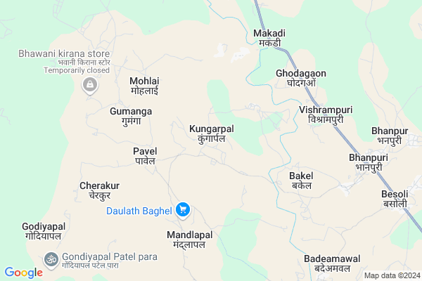
Kungarpal
Kungarpal Map
EDIT Map
Add Your House
 ..
..
Current Corona Virus Infected Patients Count in Bastar District
| City Name | District Name | Total Covid cases |
|---|
Locality Name :
Kungarpal
( कुंगरपाल )
Tehsil Name : Bastar
District : Bastar
State : Chattisgarh
Language : Oriya and Hindi
Current Time 03:01 AM
Date: Saturday , May 03,2025 (IST)
Time zone: IST (UTC+5:30)
Elevation / Altitude: 569 meters. Above Seal level
Telephone Code / Std Code: 07782
Assembly constituency : Narayanpur assembly constituency
Assembly MLA : Kedar Kashyap
Lok Sabha constituency : Bastar parliamentary constituency
Parliament MP : DEEPAK BAIJ
Serpanch Name :
Commodities Prices : Devda Market / Mandi
Rivers Near Kungarpal
Bhaskel
Markandi
Bhaskel
Markandi
About Kungarpal
Correct below Info and add more info about KungarpalKungarpal is a Village in Bastar Tehsil in Bastar District of Chattisgarh State, India. It is located 31 KM towards west from District head quarters Jagdalpur. 24 KM from Bastar. 246 KM from State capital Raipur
Karanpur ( 4 KM ) , Cherakur ( 5 KM ) , Ghodagaon ( 5 KM ) , Bakel ( 6 KM ) , Mandlapal ( 6 KM ) are the nearby Villages to Kungarpal. Kungarpal is surrounded by Bastar Tehsil towards South , Lohandiguda Tehsil towards South , Bakawand Tehsil towards East , Tokapal Tehsil towards South .
Kondagaon , Jagdalpur , Umarkote , Nabarangapur are the near by Cities to Kungarpal.
Kungarpal 2011 Census Details
Kungarpal Local Language is Oriya. Kungarpal Village Total population is 2294 and number of houses are 514. Female Population is 50.9%. Village literacy rate is 33.7% and the Female Literacy rate is 13.7%.
Population
| Census Parameter | Census Data |
| Total Population | 2294 |
| Total No of Houses | 514 |
| Female Population % | 50.9 % ( 1168) |
| Total Literacy rate % | 33.7 % ( 773) |
| Female Literacy rate | 13.7 % ( 314) |
| Scheduled Tribes Population % | 74.1 % ( 1701) |
| Scheduled Caste Population % | 0.0 % ( 1) |
| Working Population % | 56.3 % |
| Child(0 -6) Population by 2011 | 438 |
| Girl Child(0 -6) Population % by 2011 | 51.4 % ( 225) |
Kungarpal Census More Deatils.
Politics in Kungarpal
Indian National Congress , BJP , INC are the major political parties in this area.Polling Stations /Booths near Kungarpal
1)Kudhur2)Kundla
3)Madanar-2
4)Gulumkodho
5)Madlapal 1
HOW TO REACH Kungarpal
By Rail
There is no railway station near to Kungarpal in less than 10 km.Pincodes near Kungarpal
494010 ( Lohandiguda ) , 494224 ( Bhanpuri ) , 494223 ( Bastar )Colleges near Kungarpal
Govt College Bhanpuri Besoli
Address :
Bhanu Pratap Dev Government Pg College
Address : Kanker, Uttar Bastarbastar, Pin Code: 494334
Government Post Graduate College
Address : Jagdalpur, Bastar
Schools near Kungarpal
Saraswati Sishu Mandir Tahsilpara
Address : narayanpur , narayanpur , baster , Chattisgarh . PIN- 494661 , Post - Narayanpur (Narayanpur)
Govt.m.s.kanya Ashram Retawand
Address : retawand , bastar , baster , Chattisgarh . PIN- 494223 , Post - Bastar
Gyanjyoti Gumiyapal
Address : bakulwahi , narayanpur , baster , Chattisgarh . PIN- 494661 , Post - Narayanpur (Narayanpur)
Upper Primary Koliyari
Address : koliyari , narayanpur , baster , Chattisgarh . PIN- 494661 , Post - Narayanpur (Narayanpur)
Govt Health Centers near Kungarpal
1) Makdi , SUB HEALTH CENTRE MAKDI , DAHIKONGA ,2) Ghodagaon , SUB HEALTH CENTRE GHODAGAON , DAHIKONGA ,
3) SHC Mandlapal , SUB HEALTH CENTER MANDLAPAL , VILLAGE MANDLAPAL ,
Hospitals in Kungarpal,Bastar
Sub health center Bade Kanera
Bade; Kanera Road; Kondagaon; Chhattisgarh 494226; India
22.5 KM distance Detail
more ..
Schools in Kungarpal,Bastar
Shaskiya Primary School
Deoda; Bastar; NH-43; Jagdalpur; Jagdalpur; Chhattisgarh 494226; India
6.5 KM distance Detail
Electronic Shops in Kungarpal,Bastar
Jay Maa Kali Motor Rewinding Bhanpuri
c.g; Bhanpuri; Chhattisgarh 494224; India
11.6 KM distance Detail
Super Markets in Kungarpal,Bastar
Local Parks in Kungarpal,Bastar
About Kungarpal &
History
How to reach Kungarpal
Tourist Places Near By Kungarpal
Schools in Kungarpal
Colleges in Kungarpal
Temperature & weather of Kungarpal
places in Kungarpal
Kungarpal photos
More Information
How to reach Kungarpal
Tourist Places Near By Kungarpal
Schools in Kungarpal
Colleges in Kungarpal
Temperature & weather of Kungarpal
places in Kungarpal
Kungarpal photos
More Information
Village Talk
Post News or Events about this Village
Near Cities
Kondagaon 30 KM near
Jagdalpur 49 KM near
Umarkote 67 KM near
Nabarangapur 96 KM near
Kondagaon 30 KM near
Jagdalpur 49 KM near
Umarkote 67 KM near
Nabarangapur 96 KM near
Near By Taluks
Kondagaon 22 KM near
Bastar 22 KM near
Lohandiguda 28 KM near
Tokapal 42 KM near
Kondagaon 22 KM near
Bastar 22 KM near
Lohandiguda 28 KM near
Tokapal 42 KM near
Near By Air Ports
Raipur Airport 227 KM near
Vishakhapatnam Airport 268 KM near
Rajahmundry Airport 280 KM near
Vijayawada Airport 369 KM near
Raipur Airport 227 KM near
Vishakhapatnam Airport 268 KM near
Rajahmundry Airport 280 KM near
Vijayawada Airport 369 KM near
Near By Tourist Places
Bastar 42 KM near
Jagdalpur 48 KM near
Dantewada 74 KM near
Jeypore 114 KM near
Kanker 116 KM near
Bastar 42 KM near
Jagdalpur 48 KM near
Dantewada 74 KM near
Jeypore 114 KM near
Kanker 116 KM near
Near By Districts
Bastar 29 KM near
Narayanpur 71 KM near
Dantewada 73 KM near
Nabarangpur 97 KM near
Bastar 29 KM near
Narayanpur 71 KM near
Dantewada 73 KM near
Nabarangpur 97 KM near
Near By RailWay Station
Koraput Junction Rail Way Station 135 KM near
Kantabanji Rail Way Station 194 KM near
Koraput Junction Rail Way Station 135 KM near
Kantabanji Rail Way Station 194 KM near