| Home | City Bus | Maps | Villages | Cities | Rail | Tourist Places | School | College | Pin Codes | Corona Cases Count |
| Distance Calculator Bus Services IFSC Codes Trace Mobile Number Weather Search Place Trace IP Available Cash ATM/Banks Locate Polling Booth Report an Error contact People |
 ..
..
Current Corona Virus Infected Patients Count in Bankura District
| City Name | District Name | Total Covid cases |
|---|
Block Name : Patrasayer
District : Bankura
State : West Bengal
Division : Burdwan
Language : Bengali and English
Current Time 06:05 AM
Date: Saturday , May 03,2025 (IST)
Time zone: IST (UTC+5:30)
Elevation / Altitude: 61 meters. Above Seal level
Telephone Code / Std Code: 03244
Assembly constituency : Indas assembly constituency
Assembly MLA : Nirmal Kumar Dhara
Lok Sabha constituency : Bishnupur parliamentary constituency
Parliament MP : KHAN SAUMITRA
Serpanch Name :
Pin Code : 722206
Post Office Name : Patrasayer
Commodities Prices : Bishnupur(Bankura) Market / Mandi
OverView of Birsingha
- History behind BIRSINGHA
Bir Singh was the king of Bishnupur in seventeenth century . Bir Singh built the present fort, the temple of Lalji in 1658, and seven big lakes named Lalbandh, Krishnabandh, Gantatbandh, Jamunabandh, Kalindibandh, Shyambandh and Pokabandh. His queen, Siromani or Churamani, built the temples of Madan Mohan and Murali Mohan in 1665. He walled up alive all his sons, eighteen in number. The youngest, Durjan, alone escaped, having been kept in hiding by the servants.
According to the name of king Bir Singh, the name of our Village is BIRSINGHA. There are so many temple like Bishnupur at Birsingha. Most probably the village Birsingha was founded by one of his (Bir Singh's) follower with his name.
Edit below overview about Birsingha
Nationa High Way :NH19
Nationa High Way :NH116A
Kana
Dwarakeshwar
About Birsingha
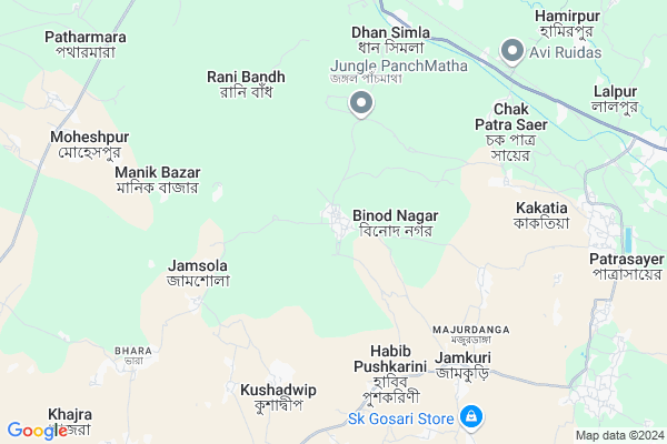
Birsingha is a Village in Patrasayer Block in Bankura District of West Bengal State, India. It belongs to Burdwan Division . It is located 47 KM towards East from District head quarters Bankura. 8 KM from Patrasayer. 136 KM from State capital Kolkata
Birsingha Pin code is 722206 and postal head office is Patrasayer .
Kushadwip ( 6 KM ) , Manikbazar ( 7 KM ) , Dhansimla ( 9 KM ) , Hamirpur ( 10 KM ) , Patrasayer ( 10 KM ) are the nearby Villages to Birsingha. Birsingha is surrounded by Sonamukhi Block towards North , Jaypur Block towards South , Indus Block towards East , Vishnupur Block towards west .
Sonamukhi , Bankura , Bardhaman , Arambagh are the near by Cities to Birsingha.
This Place is in the border of the Bankura District and Bardhaman District. Bardhaman District Khandaghosh is East towards this place .
Birsingha 2011 Census Details
Birsingha Local Language is Bengali. Birsingha Village Total population is 5231 and number of houses are 1226. Female Population is 48.5%. Village literacy rate is 59.7% and the Female Literacy rate is 24.7%.
Population
| Census Parameter | Census Data |
| Total Population | 5231 |
| Total No of Houses | 1226 |
| Female Population % | 48.5 % ( 2537) |
| Total Literacy rate % | 59.7 % ( 3121) |
| Female Literacy rate | 24.7 % ( 1294) |
| Scheduled Tribes Population % | 2.1 % ( 112) |
| Scheduled Caste Population % | 27.3 % ( 1430) |
| Working Population % | 47.1 % |
| Child(0 -6) Population by 2011 | 569 |
| Girl Child(0 -6) Population % by 2011 | 50.8 % ( 289) |
Birsingha Census More Deatils.
Politics in Birsingha
CPM , Bharatiya Janata Party , CPI(M) , AITC are the major political parties in this area.Polling Stations /Booths near Birsingha
1)Karisunda Purbapara Prathamik Vidyalaya2)Jamkuri Prathamik Vidyalaya
3)Banki Prathamik Vidyalaya
4)Alipur Prathamik Vidyalaya
5)Bhaluka Prathamik Vidyalaya
HOW TO REACH Birsingha
By Rail
Dhagaria Rail Way Station , Dhansimla Rail Way Station are the very nearby railway stations to Birsingha.Colleges near Birsingha
Patrasayer MahavidyalayaSchools in Birsingha
Bon Birsingha Boroda Sundari High SchoolGovt Health Centers near Birsingha
1) Nutan Balarampur SC , Nutan Balarampur SC , Gangtore , Near Panchayet Office2) Madhurpur SC , Madhurpur SC , Madhurpur , SKUS Madhurpur
3) Belia SC , Belia SC , JOYGERIA , JOYGERIA HIGH SCHOOL
Hospitals in Birsingha,Patrasayer
Birsingha Primary Health Centre
Village : Birsingha; P.O. : Bon Birsingha; P.S. : Patrasayer; West Bengal 722207; India
0.1 KM distance Detail
Pandua Hospital
Pandua - Kushadwip Road; Kushadwip; West Bengal 722207; India
8.9 KM distance Detail
more ..
Petrol Bunks in Birsingha,Patrasayer
Petrol pump
Bishnupur - Joykrishnapur - Patrasayer Rd; Habib Pushkarini; West Bengal 722206; India
6.2 KM distance Detail
HP PETROL PUMP - ARITWIKA FILLING STATION
P.O. Bankisole PS. Patrasayer Habibpushkarani; Durgapur; West Bengal 722206; India
6.2 KM distance Detail
Patrasayer Petrol Pump
Kankar Danga to Rasulpur Chati; Krishna Nagar; West Bengal 722206; India
11.3 KM distance Detail
more ..
Colleges in Birsingha,Patrasayer
HAZRA PARIBARER DURGA MANDIR
Bankura - Beliator - Sonamukhi - Khandaghosh - Nischintapur Road; Chak Patra Saer; West Bengal 722206; India
9.2 KM distance Detail
more ..
Schools in Birsingha,Patrasayer
Bon Birsingha Barada Sundari High School
Village : Birsingha; P.O. : Bon Birsingha; P.S. : Patrasayer;; West Bengal 722207; India
0.1 KM distance Detail
Birsingha Junior Basic School
Village: Birsingha; P.O.: Bon Birsingha; P.S.: Patrasayer; Dist. : Bankura; West Bengal 722207; India
0.1 KM distance Detail
Uttar Birsingha Primary School
Village : Birsingha; P.O. : Bon Birsingha; P.S. : Patrasayer; District : Bankura; West Bengal 722207; India
0.6 KM distance Detail
Birsingha Purba Para Primary School
Birsingha; Bon Birsingha; Patrasayer; West Bengal 722207; India
0.6 KM distance Detail
Governement Offices near Birsingha,Patrasayer
Revenue Inspector Office
Village: Birsingha; P.O.: Bon Birsingha; P.S.: Patrasayer; Dist. : Bankura; West Bengal 722207; India
0.2 KM distance Detail
How to reach Birsingha
Tourist Places Near By Birsingha
Schools in Birsingha
Colleges in Birsingha
Temperature & weather of Birsingha
places in Birsingha
Birsingha photos
More Information
Village Talk
Post News or Events about this Village
Sonamukhi 13 KM near
Bankura 44 KM near
Bardhaman 47 KM near
Arambagh 54 KM near
Patrasayer 8 KM near
Sonamukhi 14 KM near
Jaypur 22 KM near
Indus 24 KM near
Netaji Subhas Chandra Bose Airport 132 KM near
Ranchi Airport 243 KM near
Gaya Airport 343 KM near
Patna Airport 400 KM near
Bishnupur 21 KM near
Durgapur 39 KM near
Jairambati 40 KM near
Bankura 44 KM near
Bardhaman 47 KM near
Bankura 44 KM near
Bardhaman 45 KM near
Birbhum 87 KM near
Medinipur West 98 KM near
Dhagaria Rail Way Station 8.6 KM near
Dhansimla Rail Way Station 9.0 KM near
Bishnupur Junction Rail Way Station 23 KM near
Panagarh Rail Way Station 30 KM near