| Home | City Bus | Maps | Villages | Cities | Rail | Tourist Places | School | College | Pin Codes | Corona Cases Count |
| Distance Calculator Bus Services IFSC Codes Trace Mobile Number Weather Search Place Trace IP Available Cash ATM/Banks Locate Polling Booth Report an Error contact People |
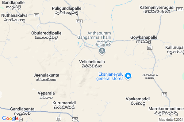
Gopalapuram
Gopalapuram Map
EDIT Map
Add Your House
 ..
..
Current Corona Virus Infected Patients Count in Anantapur District
| City Name | District Name | Total Covid cases |
|---|---|---|
| Anantapur District | Anantapur | 36 |
| Anantapur | Anantapur | 5 |
| Hindupur | Anantapur | 3 |
| R K Function Hall Backside | Anantapur | 2 |
| Lepakshi | Anantapur | 2 |
| Kalyana Durgam | Anantapur | 1 |
| Hindupur Mandal | Anantapur | 1 |
| Naik Nagar | Anantapur | 1 |
| Kothacheruvu | Anantapur | 1 |
| Aravinda Nagar | Anantapur | 1 |
Locality Name :
Gopalapuram
( గోపాలపురం )
Mandal Name : Nambulapulikunta
District : Anantapur
State : Andhra Pradesh
Region : Rayalaseema
Language : Telugu and Urdu
Current Time 03:47 AM
Date: Saturday , May 03,2025 (IST)
Time zone: IST (UTC+5:30)
Elevation / Altitude: 577 meters. Above Seal level
Telephone Code / Std Code: 08498
Assembly constituency : assembly constituency
Assembly MLA : P.V. SIDDA REDDY
Lok Sabha constituency : parliamentary constituency
Parliament MP : KURUVA GORANTLA MADHAV
Serpanch Name :
Pin Code : 515581
Post Office Name : Talupula
Main Village Name : Velichelimala
Commodities Prices : Mulakalacheruvu Market / Mandi
National Highways Reachable To Gopalapuram
Nationa High Way :NH342
Nationa High Way :NH42
Nationa High Way :NH342
Nationa High Way :NH42
Rivers Near Gopalapuram
Chitravati :ಚಿತ್ರಾವತಿ :చిత్రావతి
Madduleru River
Chitravati :ಚಿತ್ರಾವತಿ :చిత్రావతి
Madduleru River
About Gopalapuram
Correct below Info and add more info about GopalapuramGopalapuram is a small Village/hamlet in Nambulapulikunta Mandal in Anantapur District of Andhra Pradesh State, India. It comes under Velichelimala Panchayath. It belongs to Rayalaseema region . It is located 117 KM towards East from District head quarters Anantapur. 11 KM from Nambulapulikunta. 420 KM from State capital Hyderabad
Gopalapuram Pin code is 515581 and postal head office is Talupula .
Gopalapuram is surrounded by Gandlapenta Mandal towards west , Talupula Mandal towards North , Chakrayapet Mandal towards East , Galiveedu Mandal towards East .
Kadiri , Rayachoti , Yerraguntla , Kadapa are the near by Cities to Gopalapuram.
This Place is in the border of the Anantapur District and Cuddapah District. Cuddapah District Galiveedu is East towards this place .
Demographics of Gopalapuram
Telugu is the Local Language here. Total population of Gopalapuram is 3783 .Males are 1889 and Females are 1,894 living in 954 Houses. Total area of Gopalapuram is 4550 hectares.HOW TO REACH Gopalapuram
By Road
Kadiri is the Nearest Town to Gopalapuram. Kadiri is 26 km from Gopalapuram. Road connectivity is there from Kadiri to Gopalapuram.By Rail
There is no railway station near to Gopalapuram in less than 10 km. How ever there are railway Stations from Near By town Kadiri. are the railway Stations near to Kadiri. You can reach from Kadiri to Gopalapuram by road after .By Bus
Kadiri APSRTC Bus Station , Vemula APSRTC Bus Station , Thalla Palli APSRTC Bus Station are the nearby by Bus Stations to Gopalapuram .APSRTC runs Number of busses from major cities to here.Colleges near Gopalapuram
Sri Venkateswara Instute Of Technology
Address :
Naidu College
Address :
Government Junior College For Boys
Address :
Govt Junior College Kundurpi
Address : Govt Junior College Kundurpi Near Rama Swamy Temple Kundurpi Anantapur
Sri Mahatma Jr College Gooty
Address : Neha Nagar
gooty V
gooty M
anantapur Dist 515401
Schools in Gopalapuram
Mpups Veli Chala Mala
Address : velichelimala , nambulapulikunta , anantapur , Andhra Pradesh . PIN- 515581 , Post - Talupula
Mpups Gopala Puram
Address : velichelimala , nambulapulikunta , anantapur , Andhra Pradesh . PIN- 515581 , Post - Talupula
Govt Health Centers near Gopalapuram
1) Gandlapenta , 4-260-A1 , malameedapalli road , malameedapalli road2) K.Rajupalli , , MAIN ROAD , NEAR MPP SCHOOL
3) Talupula , 7-Sep , PRAKASH NAGAR , SOCITY OFFICE
Petrol Bunks in Gopalapuram,Nambulapulikunta
Sri Kalikadevi Filling Station Gandlapenta
Mallameedapalli Road; Gandlapenta; Andhra Pradesh 515521; India
12.7 KM distance Detail
more ..
Schools in Gopalapuram,Nambulapulikunta
SRI SANTHINIKATHAN RESIDENTIAL SCHOOL
Kurumamidi; Andhra Pradesh 515521; India
8.8 KM distance Detail
Electronic Shops in Gopalapuram,Nambulapulikunta
Sri Surya Digital Studio
opp Andhra Bank; Talupula; Andhra Pradesh 515581; India
16.6 KM distance Detail
Local Parks in Gopalapuram,Nambulapulikunta
Adi Narayana Reddy Mango Gardens
Naggappagari Palle; Bandlapalle Talupula; Andhra Pradesh; India
14.9 KM distance Detail
Police Stations near Gopalapuram,Nambulapulikunta
Talupula Police Station
Thappetavaripalli Rd; Talupula; Andhra Pradesh 515581; India
16.5 KM distance Detail
About Gopalapuram &
History
How to reach Gopalapuram
Tourist Places Near By Gopalapuram
Schools in Gopalapuram
Colleges in Gopalapuram
Temperature & weather of Gopalapuram
places in Gopalapuram
Gopalapuram photos
More Information
How to reach Gopalapuram
Tourist Places Near By Gopalapuram
Schools in Gopalapuram
Colleges in Gopalapuram
Temperature & weather of Gopalapuram
places in Gopalapuram
Gopalapuram photos
More Information
Village Talk
Post News or Events about this Village
Near Cities
Kadiri 23 KM near
Rayachoti 48 KM near
Yerraguntla 65 KM near
Kadapa 69 KM near
Kadiri 23 KM near
Rayachoti 48 KM near
Yerraguntla 65 KM near
Kadapa 69 KM near
Near By Taluks
Nambulapulikunta 10 KM near
Gandlapenta 12 KM near
Talupula 15 KM near
Chakrayapet 19 KM near
Nambulapulikunta 10 KM near
Gandlapenta 12 KM near
Talupula 15 KM near
Chakrayapet 19 KM near
Near By Air Ports
Bengaluru International Airport 141 KM near
Tirupati Airport 157 KM near
Chennai Airport 263 KM near
Mysore Airport 309 KM near
Bengaluru International Airport 141 KM near
Tirupati Airport 157 KM near
Chennai Airport 263 KM near
Mysore Airport 309 KM near
Near By Tourist Places
Horsley Hills 62 KM near
Puttaparthi 67 KM near
Kadapa 69 KM near
Lepakshi 99 KM near
Nandi Hills 127 KM near
Horsley Hills 62 KM near
Puttaparthi 67 KM near
Kadapa 69 KM near
Lepakshi 99 KM near
Nandi Hills 127 KM near
Near By Districts
Cuddapah 69 KM near
Anantapur 112 KM near
Chikballapur 117 KM near
Kolar 128 KM near
Cuddapah 69 KM near
Anantapur 112 KM near
Chikballapur 117 KM near
Kolar 128 KM near
Near By RailWay Station
Kadiri Rail Way Station 22 KM near
Yerraguntla Junction Rail Way Station 65 KM near
Kadiri Rail Way Station 22 KM near
Yerraguntla Junction Rail Way Station 65 KM near